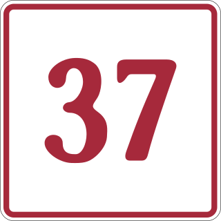
The Stewart–Cassiar Highway, also known as the Dease Lake Highway and the Stikine Highway as well as the Thornhill –Kitimat Highway from Kitimat to Thornhill, is the northwesternmost highway in the Canadian province of British Columbia. A scenic route through some of the province's most isolated areas, the highway first gained designation as British Columbia Highway 37 in the year 1975. At that time, its southern terminus was at the community of New Hazelton on the BC Highway 16. In 1975, with the completion of a new bridge over the Kitimat River, the highway's Yellowhead junction was relocated to a point on Highway 16 just south of the site of Kitwanga. Highway 37 was then extended south to Kitimat in 1986 superseding what was then designated Highway 25. At the north end, the highway briefly stretches into the Yukon, becoming Yukon Highway 37.
Cassiar is a ghost town in British Columbia, Canada. It was a small company-owned asbestos mining town located in the Cassiar Mountains of Northern British Columbia north of Dease Lake.
The 1875 British Columbia general election was held in 1875. Many of the politicians in the House had served with the Legislative Council or Assembly or the Executive Council, or had otherwise been stalwarts of the colonial era - some supporters of Confederation, others not. Some were ranchers or mining bosses from the Interior, others were colonial gentry from the Island and New Westminster, and others direct arrivals from Britain, Ireland or "Canada", which was still considered a different place not only in the minds of the politicians but in the language used in Hansard during this period.
The 1882 British Columbia general election was held in 1882.
The 1886 British Columbia general election was held in 1886. The number of members was increased for this election from 25 to 27, and the number of ridings increased to 13.
The 1890 British Columbia general election was held in 1890. The number of members was increased for this election from 27 in the previous election to 33, although the number of ridings was decreased to 18.
The 1894 British Columbia general election was held in 1894. The number of members remained at 33 with the number of ridings increased to 26 as a result of the partition of the Yale and Westminster ridings.
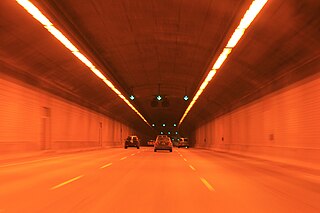
The Cassiar Connector is a highway traffic tunnel on the Trans-Canada Highway. It is located in the north-east corner of Vancouver, British Columbia, near the Vancouver-Burnaby border. Travelling northward, the tunnel begins under Adanac Street and passes under the interchange between East Hastings Street and the Highway 1 offramps. It ends underneath Triumph Street, with the highway continuing north to the McGill Street interchange and the Ironworkers Memorial Second Narrows Crossing towards the District of North Vancouver. The tunnel is 730 metres (2,400 ft) long. Dangerous goods are not permitted to be transported through the tunnel.
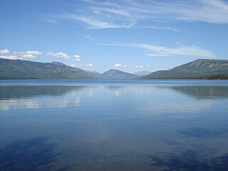
Kinaskan Lake Provincial Park is a provincial park in British Columbia, Canada, located at the south end of Kinaskan Lake along the Stewart-Cassiar Highway near Mowdade Lake and southeast of Mount Edziza. At the south end of the park, the Iskut River, of which the lake is an expansion, spills over 12.2-metre Cascade Falls. The park is approximately 800 ha. in size.

The Cassiar Mountains are the most northerly group of the Northern Interior Mountains in the Canadian province of British Columbia and also extend slightly into the southernmost Yukon Territory. They lie north and west of the Omineca Mountains, west of the northernmost Rockies and the Rocky Mountain Trench, north of the Hazelton Mountains and east of the Boundary Ranges. They form a section of the Continental Divide, that, in this region, separates water drainage between the Arctic and Pacific Oceans. Physiographically, they are a section of the larger Yukon-Tanana Uplands province, which in turn are part of the larger Intermontane Plateaus physiographic division.
The Stikine Ranges are a group of mountain ranges and mountainous plateaus in northwestern British Columbia, Canada. They are the northernmost subdivision of the Cassiar Mountains and among the least explored and most undeveloped parts of the province.

The Interior Mountains or Northern Interior Mountains are the semi-official names for an expansive collection of mountain ranges that comprises much of the northern half of the Canadian province of British Columbia and a large area of southern Yukon.

The Stikine Country, also referred to as the Stikine District or simply "the Stikine", is one of the historical geographic regions of the Canadian province of British Columbia, located inland from the central Alaska Panhandle and comprising the basin of the Stikine River and its tributaries. The term Stikine–Iskut is also fairly common to describe the area, and references the Iskut River, the Stikine's largest tributary and describable as its south fork.
The Cassiar Country, also referred to simply as the Cassiar, is a historical geographic region of the Canadian province of British Columbia. The Cassiar is located in the northwest portion of British Columbia, just to the northeast of the Stikine Country, while to the south is the Omineca Country. The area is noted for the Cassiar gold rush of the 1870s, when Laketon became its unofficial capital. The ghost town of Cassiar is also located in the Cassiar region.
Thudaka Peak is the highest mountain of the Thudaka Range of the Cassiar Mountains in the Northern Interior of British Columbia, Canada, located between the heads of Obo River and Frog River. Glaciers exist on Thudaka's northern flanks, but the zone is usually quite dry.
Hyder Seek is a long-distance motorcycle riding event held annually between 1998 and 2012. The destination is Hyder, Alaska, the closest Alaska city to the Lower 48 states that can be reached by road, about 880 miles (1,420 km) from the Sumas, Washington–British Columbia border crossing.
The Osoyoos Division Yale Land District is one of the 59 land districts of British Columbia, Canada, which are the underlying cadastral divisions of that province. All land titles and surveys use the Land District system as the primary point of reference, and entries in BC Names for placenames and geographical objects are so listed.
The Cassiar Land District is a cadastral survey subdivision of the province of British Columbia, Canada, created with rest of those on Mainland British Columbia via the Lands Act of the Colony of British Columbia in 1860. The British Columbia government's BC Names system, a subdivision of GeoBC, defines a land district as "a territorial division with legally defined boundaries for administrative purposes". All land titles and surveys use the Land District system as the primary point of reference, and entries in BC Names for placenames and geographical objects are so listed.