
Dumfries is a market town and former royal burgh in Dumfries and Galloway, Scotland, near the mouth of the River Nith on the Solway Firth, 25 miles (40 km) from the Anglo-Scottish border. Dumfries is the county town of the historic county of Dumfriesshire.

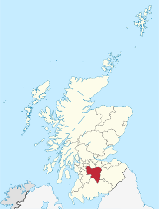
Dumfries and Galloway is one of the 32 unitary council areas of Scotland, located in the western part of the Southern Uplands. It is bordered by East Ayrshire, South Ayrshire, and South Lanarkshire to the north; Scottish Borders to the north-east; the English county of Cumbria, the Solway Firth, and the Irish Sea to the south, and the North Channel to the west. The administrative centre and largest settlement is the town of Dumfries. The second largest town is Stranraer, located 76 miles (122 km) to the west of Dumfries on the North Channel coast.
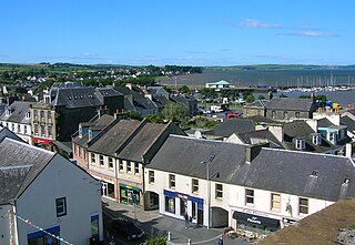
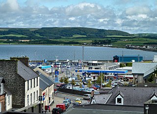
Stranraer, also known as The Toon, is a town in Dumfries and Galloway, Scotland, on Loch Ryan and the northern side of the isthmus joining the Rhins of Galloway to the mainland. Stranraer is Dumfries and Galloway's second-largest town, with a population of nearly 13,000.

Castle Douglas is a town in Dumfries and Galloway, Scotland. It lies in the lieutenancy area of Kirkcudbrightshire, in the eastern part of Galloway, between the towns of Dalbeattie and Gatehouse of Fleet. It is in the ecclesiastical parish of Kelton.
South Lanarkshire is one of 32 unitary authorities of Scotland. It borders the south-east of the Glasgow City council area and contains some of Greater Glasgow's suburban towns, as well as many rural towns and villages. It also shares borders with Dumfries and Galloway, East Ayrshire, East Renfrewshire, North Lanarkshire, the Scottish Borders and West Lothian. It includes most of the historic county of Lanarkshire.

Kirkcudbrightshire, or the County of Kirkcudbright or the Stewartry of Kirkcudbright is one of the historic counties of Scotland, covering an area in the south-west of the country. Until 1975, Kirkcudbrightshire was an administrative county used for local government. Since 1975, the area has formed part of Dumfries and Galloway for local government purposes. Kirkcudbrightshire continues to be used as a registration county for land registration. A lower-tier district called Stewartry covered the majority of the historic county from 1975 to 1996. The area of Stewartry district is still used as a lieutenancy area. Dumfries and Galloway Council also has a Stewartry area committee.
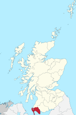
Wigtownshire or the County of Wigtown is one of the historic counties of Scotland, covering an area in the south-west of the country. Until 1975, Wigtownshire was an administrative county used for local government. Since 1975 the area has formed part of Dumfries and Galloway for local government purposes. Wigtownshire continues to be used as a territory for land registration, being a registration county. The historic county is all within the slightly larger Wigtown Area, which is one of the lieutenancy areas of Scotland and was used in local government as the Wigtown District from 1975 to 1996.

Dumfriesshire or the County of Dumfries or Shire of Dumfries is a historic county and registration county in southern Scotland. The Dumfries lieutenancy area covers a similar area to the historic county.

The Southern Uplands are the southernmost and least populous of mainland Scotland's three major geographic areas. The term is used both to describe the geographical region and to collectively denote the various ranges of hills and mountains within this region. An overwhelmingly rural and agricultural region, the Southern Uplands are partly forested and contain many areas of open moorland - the hill names in the area are congruent with these characteristics.
Lochmaben is a small town and civil parish in Scotland, and site of a castle. It lies 4 miles (6 km) west of Lockerbie, in Dumfries and Galloway. By the 12th century the Bruce family had become the local landowners and, in the 14th century, Edward I rebuilt Lochmaben Castle. It was subsequently taken by Archibald Douglas, 3rd Earl of Douglas in 1384/5 and was abandoned in the early 17th century. The town itself became a Royal Burgh in 1447.
Sorbie is a small village in Wigtownshire, Machars, within the administration area of Dumfries and Galloway Council, Scotland.
Lochend may refer to the following places:

Galloway and West Dumfries is a constituency of the Scottish Parliament (Holyrood) covering part of the council area of Dumfries and Galloway. It elects one Member of the Scottish Parliament (MSP) by the plurality method of election. It is also one of nine constituencies in the South Scotland electoral region, which elects seven additional members, in addition to the nine constituency MSPs, to produce a form of proportional representation for the region as a whole.
Loch is the Scottish Gaelic and Irish word for a lake or a sea inlet.
Inch is a civil parish in Dumfries and Galloway, southwest Scotland. It lies on the shore of Loch Ryan, in the traditional county of Wigtownshire.
Penninghame in Wigtownshire, Dumfries and Galloway, Scotland, is a civil parish area, 8 miles from Wigtown. The area is approx 16 miles in length, and from 5 to 6 miles' width, bounded on the north and east by the River Cree, and on the west by the Bladnoch; comprising nearly 38,000 acres, of which 12,000 were arable, 600 woodland and plantations, 1600 meadow, and the remainder hill pasture, moorland, moss, etc.
Old Luce is a civil parish in Dumfries and Galloway, Scotland. It lies in the Machars peninsula, in the traditional county of Wigtownshire. The parish is around 10 miles (16 km) long and 8 miles (13 km) broad, and contains 40,350 acres (16,330 ha).
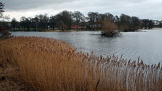
Carlingwark Loch is a small freshwater loch in the historical county of Kirkcudbrightshire, Dumfries and Galloway, Scotland lying just south of Castle Douglas and is roughly rectangular in shape, trending nearly north and south. The name of the loch comes from the Scots Gaelic word Caer meaning fort and wark the old Scots language word for work. There are four artificial islets in the loch showing evidence of fortification and settlement, Ash Island is thought to be a crannog. Several archaeological finds have been retrieved from the loch including a bronze cauldron, sword and pan and two dugout canoes.