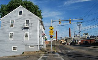
Wakefield is a village in the town of South Kingstown, Rhode Island, and the commercial center of the town. Together with the village of Peace Dale, it is treated by the U.S. Census as a component of the census-designated place identified as Wakefield-Peacedale, Rhode Island. West Kingston, another South Kingstown village, was the traditional county seat of Washington County. Since 1991, the Washington County Courthouse has been in Wakefield. The Sheriff's Office which handles corrections is also in Wakefield.

This is a list of properties and districts listed on the National Register of Historic Places in Rhode Island. As of May 29, 2015, there are more than 750 listed sites in Rhode Island. All 5 of the counties in Rhode Island have listings on the National Register.
Albion is a village and historic district in Lincoln, Rhode Island, in the United States.

Central Falls Congregational Church is an historic church located at 376 High Street in Central Falls, Rhode Island. This Shingle style wood frame structure was built in 1883 to serve a local Congregationalist congregation which was established in 1820 and had outgrown its previous space. Among the members of this church was wadding mill industrialist and Lieutenant governor of Rhode Island Henry A. Stearns.

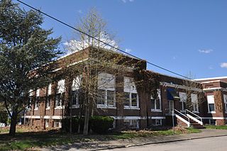
The Central Street School is an historic school building located at 379 Central Street in Central Falls, Rhode Island. This 2 1⁄2-story wood-frame building was built by the city in 1881 to meet burgeoning demand for education brought about by the success of the local mills. The building is cruciform in shape, with Italianated hooded entrances at opposited ends of the east–west axis of the building. Each floor houses two classrooms.

The Greystone Mill Historic District encompasses an early 20th-century textile mill complex on Greystone Avenue in Johnston and North Providence, Rhode Island. The complex consists of three brick buildings on the North Providence side of the Woonasquatucket River, a dam spanning the river, and a water tank near the dam in Johnston. The main structure consists of a series of structures combined to form a rambling structure, built between 1904 and 1911 to designs by Frank Sheldon and Son, an architectural firm that was a leading designer of textile facilities at the time.

The Hopkins Mill District is a historic district in Foster, Rhode Island. It encompasses a historic mill village that extends along Old Danielson Pike between its two junctions with Danielson Pike. The area has been the site of mills since the 18th century, and includes one of Foster's oldest houses, the c. 1720 Hopkins-Potter House at 21 Old Danielson Pike. Prominent public buildings in the district include the c. 1830 Curtis Hall at 18 Danielson Pike, which was long used as a tavern and social gathering place, and the 1869-71 Hopkins Falls Union Church.

The Old Ashton Historic District is a historic district encompassing an early 18th-century industrial area along Lower River Road in Lincoln, Rhode Island. It includes the site of the first textile mill in Lincoln, which was established in 1810-15, and whose original mill building no longer survives. The proprietors of the mill built a series of modest worker houses on Lower River Road, which are now separated from the mill site by a section of the Blackstone Canal. The only structure near the mill site is the Kelly House, built in the 1820s by Wilbur Kelly, one of the mill owners. The area is now a stopping point in Blackstone River Bikeway State Park, with interpretive signs explaining the area's history.

The South Central Falls Historic District is a historic district in Central Falls, Rhode Island. It is a predominantly residential area, densely populated, which was developed most heavily in the late 19th century. It is bounded roughly by Broad Street to the east, the Pawtucket city line to the south, Dexter Street to the west, and Rand Street and Jenks Park to the north. It has 377 contributing buildings, most of which were built before 1920. The district was added to the National Register of Historic Places in 1991.

The Valley Falls Mill is a historic textile mill complex on Broad Street in Central Falls, Rhode Island. The complex consists of the primary mill building, a large Italianate brick four-story building erected in 1849, several outbuildings. a dam across the Blackstone River, and a portion of the original canal system which provided water power to the mill. The outbuildings include the gatehouse controlling waterflow into the canals, a small stuccoed office building now serving as a retail establishment, and a brick bathhouse built c. 1870 that stands just south of the mill race. The complex originally had a second mill building and power canal; that building was destroyed by fire, and its canal was filled in. The main mill building was developed as housing in the late 1970s, including a sympathetic replacement for the second mill building.
The Richmond Paper Company Mill Complex is an historic American paper mill at 310 Bourne Avenue in East Providence, Rhode Island. It consists of a collection of mainly brick buildings on 13 acres (5.3 ha) of land, bounded on the north by Bourne Avenue, the east by railroad tracks, the west by the Seekonk River, and on the south by land formerly owned by the Washburn Wire Company. The first seven of the surviving buildings were built between 1883 and 1887 by the Richmond Paper Company. The property was acquired at auction in 1894 by Eugene Phillips, who operated the American Electrical Works on the premises, adding further buildings between 1900 and 1930 and demolishing several buildings specific to paper processing. The property presently sees a variety of light industrial uses. The Richmond Paper Company is notable as the place where Arthur Dehon Little started his career.

The Hamilton Mill Village Historic District is a historic district encompassing a small mill village in North Kingstown, Rhode Island. It is located on the south side of the Annaquatucket River, near its mouth at Bissell Cove. The village includes two wood-frame mill buildings and a collection of mill worker housing units, which line a short section of Boston Neck Road as well as Salisbury Avenue, Web Avenue, and Martha Road. The most impressive mill building is the main mill, built in 1853 and enlarged in 1866 with a double clerestory roof, something not found in other surviving mills in the state.

The Bridge Mill Power Plant is an historic hydroelectric plant at 25 Roosevelt Avenue in Pawtucket, Rhode Island. It is a red brick building, with sections two and three stories in height, located on the west bank of the Seekonk River. An ashlar granite retaining wall obscures a conduit which delivers water to the facility from the Pawtucket Falls Dam. The facility has three parts: a gate house, which controls the flow of water into the power house, where five turbines were located. A boiler house housed a steam generation facility which was used to generate power when the water levels were too low for hydroelectric power generation. Built in 1893, this is probably the best-preserved 19th-century hydroelectric power station in Rhode Island.
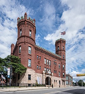
The Exchange Street Historic District is an industrial and civic historic district roughly along Exchange, Front and Fountain Streets in Pawtucket, Rhode Island. The 10.5-acre (4.2 ha) area is located just north of Pawtucket's downtown, and includes seven buildings and the Exchange Street Bridge, which spans the Blackstone River. The seven buildings are sandwiched between the river to the west, Broadway to the east, Blackstone Avenue to the north, and Front and Exchange Streets on the south. The most prominent buildings in the district are the 1926 William E. Tolman High School, sited high above the river just north of Exchange Street, and the Pawtucket Armory, built in 1895 and featuring crenellated towers. South of Exchange Street stand several mill buildings dating as far back as 1874.

Pawtucket City Hall is located at 137 Roosevelt Avenue, just outside the central business district of Pawtucket, Rhode Island. The Art Deco-style building was designed by Providence architect John O'Malley and was built in 1933. It has a large rectangular main block, fifteen bays wide, whose central, three-bay portion projects slightly. Above this section, rises a tower 209 feet (64 m) in height. The main block, which houses the Pawtucket City Hall offices, is four stories high, and it is flanked on either side by squat projecting wings that are three stories high. The left wing houses the central fire station, while the right wing houses the police department headquarters.

Slater Park is the oldest and largest public park in Pawtucket, Rhode Island. The park is named after Samuel Slater, a famous American industrialist who constructed America's first water-powered textile mill in Pawtucket. The park lies on the banks of the beautiful Ten Mile River and features the 1685 Daggett House, the oldest house in Pawtucket. The park was added to the National Register of Historic Places in 1976. It also features an original Looff Carousel.

The Greystone Historic District is a historic district encompassing the early 20th-century mill village of Greystone in North Providence, Rhode Island. The district most significant elements is the Greystone Mill, a complex of brick industrial buildings on the North Providence side of the Woonasquatucket River, as well as the dam spanning the river and a water tank in Johnston. The village, entirely in North Providence, was developed between 1904 and 1912 by Joseph Benn and Company, the mill proprietors, to provide housing for its workers. The main focus of the village is on junction of Greystone Road and Oakleigh Avenue. The company built a variety of housing types, including duplexes and tenements, which line some of the side streets. There are four houses, dating as far back as 1822, that predate the primary industrial activity here. The most prominent feature of the village is the Greystone (Primitive) Methodist Church on Oakleigh Avenue.

The Phillipsdale Historic District encompasses a historic mill village along the Seekonk River in East Providence, Rhode Island. The village grew up around the Richmond Paper Company Mill Complex, built 1883-1887, which is separately listed on the National Register. It also includes 75 units of worker housing, as well as five houses that predate the mill complex's construction. The Phillipsdale area was the largest source of employment in East Providence between 1893 and 1910. The district is centered on Roger Williams Avenue and Bourne Avenue, and includes properties on Ruth Avenue and the grid of roads between Ruth and Roger Williams. It also includes Omega Pond.