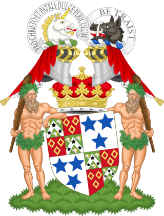
The Duke of Roxburghe is a title in the peerage of Scotland created in 1707 along with the titles Marquess of Bowmont and Cessford, Earl of Kelso and Viscount Broxmouth. John Ker, 5th Earl of Roxburghe became the first holder of these titles. The title is derived from the royal burgh of Roxburgh in the Scottish Borders that in 1460 the Scots captured and destroyed.

Clan Kerr is a Scottish clan whose origins lie in the Scottish Borders. During the Middle Ages, it was one of the prominent border reiver clans along the present-day Anglo-Scottish border and played an important role in the history of the Border country of Scotland.

Cessford Castle is a large ruined mid-15th century L-plan castle near the village of Cessford, midway Jedburgh and Kelso, in the historic county of Roxburghshire, now a division of the Scottish Borders. The Castle is caput of the Barony of Cessford, and the principal stronghold of the Kers/Kerrs, notorious Border Reivers, many of whom served as Wardens of the Middle March.
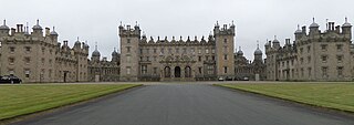
Floors Castle, in Roxburghshire, south-east Scotland, is the seat of the Duke of Roxburghe. Despite its name it is an estate house rather than a fortress. It was built in the 1720s by the architect William Adam for Duke John, possibly incorporating an earlier tower house. In the 19th century it was embellished with turrets and battlements, designed by William Playfair, for The 6th Duke of Roxburghe. Floors has the common 18th-century layout of a main block with two symmetrical service wings. Floors Castle stands by the bank of the River Tweed and overlooks the Cheviot Hills to the south.

Nisbet is a small hamlet on the B6400, in Roxburghshire, along the River Teviot, in the Scottish Borders area of Scotland. It is located 5.5 kilometres (3.4 mi) north of Jedburgh and 5 kilometres (3.1 mi) south of Roxburgh.
Cessford Burn is a small stream which eventually runs to meet the Kale Water and then joins the River Teviot, finally entering the River Tweed at Kelso, Scotland.
Holydean Castle was a castle sited near Melrose in Bowden, 1.25 miles SW of the village, in the Scottish Borders region of Scotland, and the former Roxburghshire.
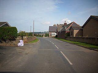
Maxton is a hamlet and civil parish in Roxburghshire, Scotland, and part of the Scottish Borders region.
Bowden is a village in the Roxburghshire area of the Scottish Borders, situated 3 miles south of Melrose, 2 miles west of Newtown St Boswells and tucked in the shadow of the Eildon Hills, Scotland.

Blanerne Castle is the remains of a 16th-century fortified house, located in the grounds of Blanerne House, an 18th-century country house between Chirnside and Preston in the Scottish Borders. The house and castle sit on the north bank of the Whiteadder Water, around 6 kilometres (3.7 mi) north-east of Duns.

Camptown is a small settlement on the A68, in the Scottish Borders area of Scotland, 5m (8 km) south of Jedburgh, and the same distance south to Carter Bar. The village lies on the course of the Jed Water, and the remains of a peel tower are close by at Edgerston.

The Kale Water is a 20 miles (32 km) long tributary of the River Teviot in the Scottish Borders area of Scotland. Its feeder burns in the Cheviot Hills are the Long Burn, Hawkwillow Burn and the Grindstone Burn, east of Leithope Forest near the Anglo-Scottish Border.
Eckford is a small village located between the larger towns of Kelso and Jedburgh in the Scottish Borders. The village is in close proximity to both the River Teviot and its tributary the Kale Water, and the A698 and the B6401 which run approximately parallel to the respective rivers.

Liddel Castle is a ruined castle in Liddesdale, by the Liddel Water, near Castleton in the Scottish Borders area of Scotland, in the former county of Roxburghshire. Liddel Castle is a scheduled monument.
Dinlabyre is a village on the B6357 in Liddesdale, on the edge of the Newcastleton Forest, close to Castleton, in the Scottish Borders area of Scotland, in the former Roxburghshire.

Cranshaws is a village on the B6355 road, near Duns, in the Scottish Borders area of Scotland, in the former Berwickshire.
Darnhall Mains is a farm and settlement off the A703, near Eddleston and the Eddleston Water in the Scottish Borders area of Scotland, in the former Peeblesshire.

Mangerton Tower is a ruined Scottish tower castle house formerly belonging to the Armstrong family.

Wallace's Tower is a ruined 16th-century L-plan tower house, about 3 miles (4.8 km) south west Kelso, Scottish Borders, Scotland, in Roxburgh, west of the River Teviot.
