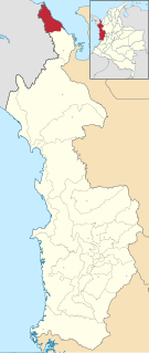
Chacabuco Department, Chaco

Last updated
Chacabuco
Departamento Chacabuco (Chaco - Argentina).png
Location of Chacabuco Department in Chaco Province
Coordinates: 27°13′S61°12′W / 27.217°S 61.200°W / -27.217; -61.200 Coordinates: 27°13′S61°12′W / 27.217°S 61.200°W / -27.217; -61.200
Country Argentina
Province Chaco Province
Capital Charata
Area
  Total 1,378 km2 (532 sq mi)
Population [1]
  Total 27,813
  Density 20/km2 (52/sq mi)
Demonym(s) Charatense
Area code(s) 03731
Distance to Buenos Aires 1,100 km (680 mi)
Distance to Resistencia 214 km (133 mi)
Website https://web.archive.org/web/20070504133942/http://www.charata.gov.ar/

Chacabuco is a western department of Chaco Province in Argentina.

Departments of Argentina

Departments form the second level of administrative division, and are subdivided in municipalities. They are extended in all of Argentina except for the Province of Buenos Aires and the Autonomous City of Buenos Aires, the national capital, each of which has different administrative arrangements.

Chaco Province Province of Argentina

The Province of Chaco is a province in north-eastern Argentina.

Argentina federal republic in South America

Argentina, officially named the Argentine Republic, is a country located mostly in the southern half of South America. Sharing the bulk of the Southern Cone with Chile to the west, the country is also bordered by Bolivia and Paraguay to the north, Brazil to the northeast, Uruguay and the South Atlantic Ocean to the east, and the Drake Passage to the south. With a mainland area of 2,780,400 km2 (1,073,500 sq mi), Argentina is the eighth-largest country in the world, the fourth largest in the Americas, and the largest Spanish-speaking nation. The sovereign state is subdivided into twenty-three provinces and one autonomous city, Buenos Aires, which is the federal capital of the nation as decided by Congress. The provinces and the capital have their own constitutions, but exist under a federal system. Argentina claims sovereignty over part of Antarctica, the Falkland Islands, and South Georgia and the South Sandwich Islands.

The provincial subdivision has a population of about 28,000 inhabitants in an area of 1,378 km2 (532 sq mi), and its capital city is Charata, which is located around 1,100 km (680 mi) from the Capital federal.

Charata City in Chaco, Argentina

Charata is a city in the province of Chaco, Argentina. It has 26497 inhabitants as per the 2010 census [INDEC], and is the head town of the Chacabuco Department and the most important city in the southwest of Chaco, located 280 km from the provincial capital Resistencia.

Related Research Articles

Provinces of the Netherlands first-level administrative division in the Netherlands

There are currently twelve provinces of the Netherlands, representing the administrative layer between the national government and the local municipalities, with responsibility for matters of subnational or regional importance.

Indre Department of France

Indre is a department in central France named after the river Indre. The inhabitants of the department are called Indriens. Indre is part of the current region of Centre-Val de Loire and is surrounded by the departments of Indre-et-Loire, Loir-et-Cher, Cher, Creuse, Vienne, and Haute-Vienne. The préfecture (capital) is Châteauroux and there are three subpréfectures at Le Blanc, La Châtre and Issoudun.

Loiret Department of France

Loiret is a department in the Centre-Val de Loire region of north-central France.

Canton of St. Gallen Canton of Switzerland

The canton of St. Gallen, also canton of St Gall, is a canton of Switzerland. The capital is St. Gallen.

Murrumbidgee River river in New South Wales, Australia

Murrumbidgee River, a major tributary of the Murray River within the Murray–Darling basin and the second longest river in Australia. It flows through the Australian state of New South Wales and the Australian Capital Territory. It descends 1,500 metres (4,900 ft) as it flows 1,485 kilometres (923 mi) in a west-northwesterly direction from the foot of Peppercorn Hill in the Fiery Range of the Snowy Mountains towards its confluence with the Murray River near Boundary Bend.

Manali, Himachal Pradesh Town in Himachal Pradesh, India

Manali is a resort town nestled in the mountains of the Indian state of Himachal Pradesh near the northern end of the Kullu Valley in the Beas River Valley. It is located in the Kullu district, about 270 km (168 mi) north of the state capital, Shimla, 309 km north east of Chandigarh and 544 km northeast of Delhi, the federal capital. The small town, with a population of 8,096, is the beginning of an ancient trade route to Ladakh and from there over the Karakoram Pass on to Yarkand and Khotan in the Tarim Basin. It is a popular tourist destination and serves as the gateway to Lahaul and Spiti district as well as Leh.

Lectoure Commune in Occitanie, France

Lectoure is a commune in the Gers department in the Occitanie region in southwestern France.

Dimont Commune in Hauts-de-France, France

Dimont is a commune in the Nord department in northern France.

Debak Place in Sarawak, Malaysia

Debak is a very small town and a sub-district in the Betong division of Sarawak, Malaysia. It lies approximately 120 kilometres (75 mi) east of the state capital Kuching.

Barran Commune in Occitanie, France

Barran is a commune in the Gers department in southwestern France.

San Lorenzo Department, Chaco Department in Chaco Province, Argentina

San Lorenzo is a department of Chaco Province in Argentina.

Noironte Commune in Bourgogne-Franche-Comté, France

Noironte is a commune in the Doubs department in the Bourgogne-Franche-Comté region in eastern France.

Acandí Municipality and town in Chocó Department, Colombia

Acandí is a town in Colombia at the northern end of the department of Chocó in northwest of Colombia, bordering the Caribbean Sea. It is 366 km (227 mi) from the provincial capital, Quibdó. Its average temperature is 28 degrees Celsius (82 °F). It was founded around the year 1887, and it became a municipality in 1905, previously being part of Turbo. The name "Acandí" is a corruption of the indigenous word "Acanti", which means "River of Stone".

Paso de los Libres Department Department in Argentina

Paso de los Libres Department is a department of Corrientes Province in Argentina.

La Celle-sur-Nièvre Commune in Bourgogne-Franche-Comté, France

La Celle-sur-Nièvre is a commune in the Nièvre department in central France.

National Highway 44 is the longest-running major north–south National Highway in India. It begins from Srinagar and terminates in Kanyakumari; the highway passes through the states of Jammu & Kashmir, Punjab, Haryana, Delhi, Uttar Pradesh, Madhya Pradesh, Maharashtra, Telangana, Andhra Pradesh, Karnataka, and Tamil Nadu. NH-44 was laid and is maintained by Central Public Works Department (CPWD).

The following radio stations broadcast on AM frequency 1400 kHz. 1400 kHz is defined as a Class C (local) frequency in the coterminous United States and such stations on this frequency are limited to 1,000 watts. U.S. stations outside the coterminous United States on this frequency are defined as Class B (regional) stations.

Entre Ríos, Cochabamba Town in Cochabamba Department, Bolivia

Entre Ríos is a small town in the Cochabamba Department of the South American Republic of Bolivia.

Bourgogne-Franche-Comté Administrative region of France

Bourgogne-Franche-Comté is a region of France created by the territorial reform of French Regions in 2014, from a merger of Burgundy and Franche-Comté. The new region came into existence on 1 January 2016, after the regional elections of December 2015, electing 100 members to the regional council of Bourgogne-Franche-Comté.

References