Changzhou Island

Last updated
Changzhou Island

Canton River, 26 May 1841.jpg

"Part of the Canton River" in 1841, a map showing Guangzhou and its surrounding islands during the First Opium War. Changzhou ("Dane Is.") lies in the east, Xiaoguwei ("French Is.") to its south, and Pazhou ("Whampoa Is.") to its northwest.
Traditional Chinese 長洲
Simplified Chinese 长洲
Postal Dane's Island
Sunqua's c. 1840View of the Foreign Cemetery on Dane's Island Foreign cemetery on Dane's Island.jpg
Sunqua's c.1840View of the Foreign Cemetery on Dane's Island

Changzhou Island, formerly known in English as Dane or Dane's Island, is an island in the Pearl River Delta of China's Guangdong Province. It is now administered as part of Guangzhou's Huangpu District, although the historic Huangpu Island was nearby Pazhou, which forms part of Haizhu District.

English language West Germanic language

English is a West Germanic language that was first spoken in early medieval England and eventually became a global lingua franca. It is named after the Angles, one of the Germanic tribes that migrated to the area of Great Britain that later took their name, as England. Both names derive from Anglia, a peninsula in the Baltic Sea. The language is closely related to Frisian and Low Saxon, and its vocabulary has been significantly influenced by other Germanic languages, particularly Norse, and to a greater extent by Latin and French.

Pearl River Delta Metropolitan region and area

The Pearl River Delta Metropolitan Region is the low-lying area surrounding the Pearl River estuary, where the Pearl River flows into the South China Sea. It is one of the most densely urbanized regions in the world, and is often considered an emerging megacity. The region's economy is referred to as Pearl River Delta Economic Zone, while the Chinese government's development plans consider it part of the Guangdong-Hong Kong-Macau Greater Bay Area.

China State in East Asia

China, officially the People's Republic of China (PRC), is a country in East Asia and the world's most populous country, with a population of around 1.404 billion. Covering approximately 9,600,000 square kilometers (3,700,000 sq mi), it is the third- or fourth-largest country by total area. Governed by the Communist Party of China, the state exercises jurisdiction over 22 provinces, five autonomous regions, four direct-controlled municipalities, and the special administrative regions of Hong Kong and Macau.

Contents

Geography

Changzhou is about 11.5 km2 (4.4 sq mi), of which 8.5 km2 (3.3 sq mi) is dry land. [1]

History

During the Canton trade, Changzhou was used by Danish crews for repairs and burials. It lay on the eastern side of the Huangpu or "Whampoa" anchorage.

Canton System Chinese policy according to which all trade with the West was conducted in Guangzhou (Canton)

The Canton System (1757–1842) served as a means for China to control trade with the West within its own country by focusing all trade on the southern port of Canton. Known in Chinese as the Yīkǒu tōngshāng the policy arose in 1757 as a response to a perceived political and commercial threat from abroad on the part of successive Chinese emperors.

The island was the site of Sun Yat-sen's Whampoa Military Academy [2] (est. 1924) and the 1926 Zhongshan Incident that propelled the academy's commandant Chiang Kai-shek to leadership over the Chinese Nationalists and then all of Warlord China.

Sun Yat-sen Chinese physician, politician and revolutionary

Sun Yat-sen was the founding father of the Republic of China. The provisional first president of the Republic of China, Sun was a Chinese medical doctor, writer, philosopher, Georgist, calligrapher, and revolutionary. As the foremost pioneer and first leader of a Republican China, Sun is referred to as the "Father of the Nation" in the Republic of China (ROC) and the "forerunner of democratic revolution" in the People's Republic of China (PRC). Sun played an instrumental role in the overthrow of the Qing dynasty during the years leading up to the Xinhai Revolution. He was appointed to serve as Provisional President of the Republic of China when it was founded in 1912. He later co-founded the Kuomintang, serving as its first leader. Sun was a uniting figure in post-Imperial China, and he remains unique among 20th-century Chinese politicians for being widely revered amongst the people from both sides of the Taiwan Strait.

Chiang Kai-shek Chinese politician and military leader

Chiang Kai-shek, also known as Generalissimo Chiang or Chiang Chungcheng and romanized as Chiang Chieh-shih or Jiang Jieshi, was a Chinese politician and military leader who served as the leader of the Republic of China between 1928 and 1975, first in mainland China until 1949 and then in Taiwan until his death. He was recognized by much of the world as the head of the legitimate government of China until 1971, during which the United Nations passed Resolution 2758.

Warlord Era Period in the history of the Republic of China

The Warlord Era was a period in the history of the Republic of China when control of the country was divided among former military cliques of the Beiyang Army and other regional factions, which were spread across the mainland regions of Sichuan, Shanxi, Qinghai, Ningxia, Guangdong, Guangxi, Gansu, Yunnan, and Xinjiang.

Transportation

Changzhou is now linked to Guangzhou's road network by a bridge to neighboring Xiaoguwei.

Xiaoguwei subdistrict of Guangdong Province, China

Xiaoguwei, formerly known in English as French Island, is an island in the Pearl River Delta of China's Guangdong Province. It is now administered as part of Xinzao (新造镇), a town in Guangzhou's Panyu District. The Guangzhou Higher Education Mega Center now occupies the entire island.

Related Research Articles

Republic of China Military Academy Military academy of the Republic of China

The Republic of China Military Academy is the military academy for the army of the Republic of China, located in Fengshan District, Kaohsiung. Previously commonly known as the Whampoa Military Academy, the military academy produced many prestigious commanders who fought in many of China's conflicts in the 20th century, notably the Northern Expedition, the Second Sino-Japanese War and the Chinese Civil War.

Whampoa is a romanisation of 黄埔, the name of Huangpu District, Guangzhou, China. It may refer to:

Huangpu, also formerly romanized Whangpoo or Whang-Po, may refer to:

Haizhu District District in Guangdong, Peoples Republic of China

Haizhu District is one of the ten districts in Guangzhou, capital of Guangdong province, People's Republic of China.

Panyu District District in Guangdong, Peoples Republic of China

Panyu, formerly romanized as Punyu, is a district of Guangzhou, the capital of Guangdong province in southern China. It is the site of the oldest parts of Guangzhou, dating back to the Qin Empire, although it was a separate county-level city before its incorporation into modern Guangzhou. The present district covers an area of about 661.88 square kilometres (255.55 sq mi).

Tianhe District District in Guangdong, Peoples Republic of China

Tianhe District is one of the eleven districts of Guangzhou, the capital of Guangdong province. In Chinese, the name Tianhe literally means "a river in the sky/heavens", which is also a Chinese name for the Milky Way. It is bordered by Yuexiu District on the west, Baiyun District on the north and Huangpu District on the east. Haizhu District is on its south, though they are separated by the Pearl River.

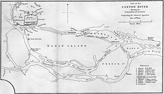
Port of Guangzhou is the main seaport of Guangzhou city, Guangdong province, China. The port is operated by Guangzhou Port Group Co. Ltd which is a state owned company. The company was established on February 26, 2004 from the former Guangzhou Harbor Bureau. It was approved by the Guangzhou Municipal Government. It is currently the largest comprehensive port in South China. Its international maritime trade reaches over 300 ports in more than 80 countries and districts worldwide. The port also incorporates the former Huangpu Port.

Huangpu District, Guangzhou District in Guangdong, Peoples Republic of China

Huangpu , formerly romanized as Whampoa, is one of the ten districts of Guangzhou, the capital of Guangdong Province, China. Despite its name, it does not include Huangpu Island or its famous anchorage. Huangpu absorbed Guangzhou's former Luogang District in 2014.

Geography of Shanghai

The geography of Shanghai is characterised by its location on the Yangtze River Delta on China's east coast and its proximity to the Pacific Ocean via the East China Sea. The city is centred on the Huangpu River, a tributary of the Yangtze River, and extends outwards in all directions, with the suburbs and satellite towns reaching east to the East China Sea, north and west to Jiangsu province, and south to Zhejiang province over Hangzhou Bay.

Zhujiang New Town

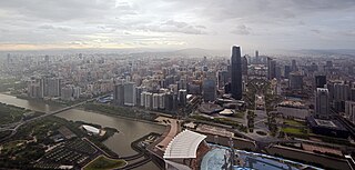
Zhujiang New Town or New City is an area in Guangzhou, Guangdong, China. It is bounded by Huangpu Avenue on the north, the Pearl River on the south, Guangzhou Avenue on the west and the South China Expressway on the east.

Chebeinan station Guangzhou Metro interchange station

Chebeinan Station, literally Chebei South Station and formerly Huangzhou Station (黄洲站) when planning, is an interchange station of Guangzhou Metro Line 4 and Line 5. It is located at the underground of the junction of Chebei Road and Huangpu Avenue East in Tianhe District. It opened on 28 December 2009. A public toilet was built outside the station for the convenience of passengers.

Wenchong station Guangzhou Metro station

Wenchong Station, formerly Wenyuan Station (文圆站), is a terminus of Line 5 of the Guangzhou Metro. It is located under the junction of Dashadi Donglu (大沙地东路) and Shihua Lu (石化路), in the Huangpu District. It opened in December 2009. In the future, Line 5 is planned to be extended from Wenchong Station to the Huangpu Coach Terminal Station.

Dashadi station Guangzhou Metro station

Dashadi Station, formerly Gangwanlu Station (港湾路站) during planning, is a station on Line 5 of the Guangzhou Metro. It is located underground the junction of West Dashadi Road (大沙地西路) and Gangwan Road (港湾路), in the Huangpu District of Guangzhou, near Huangpu Police Station, Dashadi Shopping City and Huangpu Commercial City. It opened in December 2009.

Pazhou subdistrict of Guangdong Province, China

Pazhou is a subdistrict of Haizhu in southeastern Guangzhou, Guangdong Province, in China.

Luoxi Island is an island in Dashi Town (大石镇), Panyu District, Guangzhou City, Guangdong Province,China. It is located in the northeast of Nanpu Island to the south of Haizhu Island and to the west of Xiaoguwei Island. It is about 9.85 square kilometres (3.80 sq mi) in area and connects to the Guangzhou urban area via the Luoxi Bridge (洛溪大桥), Xinguang Bridge (新光大桥) and Panyu Bridge (番禺大桥).

Shaji is an area adjacent to Yanjiang West Road (沿江西路) in the Liwan District of Guangzhou City, Guangdong Province, China. It lies opposite Shamian Island where on 23 June 1925, there was a massacre in which Chinese demonstrators and one French merchant died in an exchange of fire between British and French marines guarding the foreign concessions and cadets from the Whampoa Military Academy.

Pazhou Pagoda building in Pazhou Pagoda, China

The Pazhou Pagoda, also known as the Whampoa Pagoda or Pa Chow Pogoda, is an ancient Chinese pagoda on Pazhou Island in Haizhu District, Guangzhou, the capital of China's Guangdong Province.

Huacheng Square

Huacheng Square, or Flower City Square, is the largest city square in the city of Guangzhou. The square is situated on the city axis in Zhujiang New Town, occupies a 56-square-kilometre-large (22 sq mi) area with Haixinsha Island to its south and Huangpu Avenue to its north. Guangzhou Opera House, Guangdong Museum and Guangzhou Library are also located around the square.

Guangdong Nanhua Vocational College of Industry and Commerce is a public vocational college in Guangdong, China.

References

  1. "Changzhou Island Cultural and Tourist Resort", Official site, Guangzhou: Huangpu District Government.
  2. "Cycling on Changzhou Island", Life of Guangzhou.

Coordinates: 23°04′52″N113°24′48″E / 23.08111°N 113.41333°E / 23.08111; 113.41333

Geographic coordinate system Coordinate system

A geographic coordinate system is a coordinate system that enables every location on Earth to be specified by a set of numbers, letters or symbols. The coordinates are often chosen such that one of the numbers represents a vertical position and two or three of the numbers represent a horizontal position; alternatively, a geographic position may be expressed in a combined three-dimensional Cartesian vector. A common choice of coordinates is latitude, longitude and elevation. To specify a location on a plane requires a map projection.