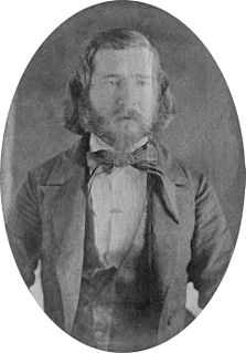
A private in the Fourth Infantry, Charles Howard served as photographer for the Stanton Expedition in 1877, traveling throughout eastern Wyoming, western Nebraska and into the Black Hills of Dakota Territory.
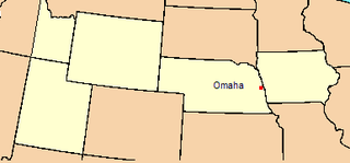
Wyoming is a state in the mountain region of the western United States. The state is the 10th largest by area, the least populous, and the second most sparsely populated state in the country. Wyoming is bordered on the north by Montana, on the east by South Dakota and Nebraska, on the south by Colorado, on the southwest by Utah, and on the west by Idaho and Montana. The state population was estimated at 577,737 in 2018, which is less than 31 of the most populous U.S. cities including neighboring Denver. Cheyenne is the state capital and the most populous city, with an estimated population of 63,624 in 2017.
Nebraska is a state that lies in both the Great Plains and the Midwestern United States. It is bordered by South Dakota to the north; Iowa to the east and Missouri to the southeast, both across the Missouri River; Kansas to the south; Colorado to the southwest; and Wyoming to the west. It is the only triply landlocked U.S. state.
The Black Hills are a small and isolated mountain range rising from the Great Plains of North America in western South Dakota and extending into Wyoming, United States. Black Elk Peak, which rises to 7,244 feet (2,208 m), is the range's highest summit. The Black Hills encompass the Black Hills National Forest. The name "Black Hills" is a translation of the Lakota Pahá Sápa. The hills were so-called because of their dark appearance from a distance, as they were covered in trees.
Charles Howard was born, according to his enlistment record, in about 1842 in Rockingham County, Virginia. Little is known of his early life. He is probably the Charles Howard recorded in the 1870 census in Portsmouth, Ohio.[1]
Rockingham County is a county located in the U.S. state of Virginia. As of the 2010 census, the population was 76,314. Its county seat is the independent city of Harrisonburg.
Virginia, officially the Commonwealth of Virginia, is a state in the Southeastern and Mid-Atlantic regions of the United States located between the Atlantic Coast and the Appalachian Mountains. Virginia is nicknamed the "Old Dominion" due to its status as the first English colonial possession established in mainland North America and "Mother of Presidents" because eight U.S. presidents were born there, more than any other state. The geography and climate of the Commonwealth are shaped by the Blue Ridge Mountains and the Chesapeake Bay, which provide habitat for much of its flora and fauna. The capital of the Commonwealth is Richmond; Virginia Beach is the most populous city, and Fairfax County is the most populous political subdivision. The Commonwealth's estimated population as of 2018 is over 8.5 million.
Portsmouth is a city in and the county seat of Scioto County, Ohio, United States. Located in southern Ohio 41 miles (66 km) south of Chillicothe, it lies on the north bank of the Ohio River, across from Kentucky, just east of the mouth of the Scioto River. The population was 20,226 at the 2010 census.
On June 16, 1875, Howard decided to enlist in the army, going into a recruiting office in Cleveland, Ohio. His enlistment papers describe the thirty-three-year-old man as 5 foot 5inches tall, with hazel eyes, brown hair and a dark complexion. From Cleveland, he was sent to Newport Barracks, Kentucky for orientation. A musician by trade, Recruit Howard was assigned to the Fourth Infantry Band.[2] He was sent to Fort Omaha, Nebraska, headquarters of the Department of the Platte, and then left with 158 other new recruits aboard a Union Pacific train for Carter Station in southwest Wyoming. From there, the detachment of recruits marched the eleven miles south to Fort Bridger, headquarters of the Fourth Infantry, where they arrived on the afternoon of September 10, 1875.[3]
Ohio is a Midwestern state in the Great Lakes region of the United States. Of the fifty states, it is the 34th largest by area, the seventh most populous, and the tenth most densely populated. The state's capital and largest city is Columbus.
Cleveland is a major city in the U.S. state of Ohio, and the county seat of Cuyahoga County. The city proper has a population of 385,525, making it the 51st-largest city in the United States, and the second-largest city in Ohio. Greater Cleveland is ranked as the 32nd-largest metropolitan area in the U.S., with 2,055,612 people in 2016. The city anchors the Cleveland–Akron–Canton Combined Statistical Area, which had a population of 3,515,646 in 2010 and is ranked 15th in the United States.
Newport Barracks was a military barracks on the Ohio River, across from Cincinnati, Ohio in Newport, Kentucky. It was operational from 1803 until 1894.
Fort Bridger
Photographers had been passing through this frontier military post since almost the inception of the art form. Daguerreotypist John Wesley Jones visited the garrison in 1851 and Samuel C. Mills, traveling with the Army bound for Utah, produced at least one image of Fort Bridger in 1858. Salt Lake City photographer Charles W. Carter came during the winter of 1866–67 and his former mentor, Charles Savage, visited a number of times between 1866 and the early 1870s. The noted Union Pacific Railroad photographer Andrew J. Russell also stopped here in 1869. Census records show a photographer named Simeon Pierson at the post in 1870. Fort Bridger had a long tradition of photographers at the post.
During his lifetime, Samuel C. Mills was an American photographer, Civil War veteran, and a D.C. judge. He is best known for his 1858 photographs from along the Oregon Trail and California Trail.
Salt Lake City is the capital and the most populous municipality of the U.S. state of Utah. With an estimated population of 190,884 in 2014, the city is the core of the Salt Lake City metropolitan area, which has a population of 1,153,340. Salt Lake City is further situated within a larger metropolis known as the Salt Lake City–Ogden–Provo Combined Statistical Area. This region is a corridor of contiguous urban and suburban development stretched along an approximately 120-mile (190 km) segment of the Wasatch Front, comprising a population of 2,423,912 as of 2014. It is one of only two major urban areas in the Great Basin.
Charles Roscoe Savage was a British-born landscape and portrait photographer most notable for his images of the American West. Savage converted to the Mormon Church in his youth while living in England. He served a Mormon mission in Switzerland and eventually moved to the United States. In America he became interested in photography and began taking portraits for hire in the East. He traveled to Salt Lake City with his family and opened up his Art Bazar where he sold many of his photographs. Savage concentrated his photographic efforts primarily on family portraits, landscapes, and documentary views. He is best known for his 1869 photographs of the linking of the first transcontinental railroad at Promontory, Utah.
It is not known if Private Howard had previously trained as a photographer or if he acquired his skills after arriving at Fort Bridger, but by the summer of 1876, he was actively producing photographs of the post and the surrounding area. He created landscape views of the Black River Valley and of nearby Church Buttes in the Green River badlands, as well as views of the fort itself. Private Howard also produced portraits. Captain William H. Bisbee, Fourth Infantry, sent a payment for photographs of his child to Howard through the post trader at Fort Bridger, complaining that "they are not at all good." Two tintypes, bearing the name "C. Howard, Artistic Photographer, Fort Bridger, Wy. Ty." have survived, examples of this soldier-photographer's portraiture work.[4]
Life for Private Howard at Fort Bridger was probably typical of the experience of most soldiers stationed at frontier posts. Private Howard's duty with the regimental band however did afford him a few privileges and an occasional opportunity to travel off the garrison. In July 1876, for example, he and other bandsmen were invited to Ogden, Utah Territory, to perform at a town celebration. Private Howard was then granted three days leave in Salt Lake City. Here he could have obtained additional photography supplies at establishments such as the Art Bazaar, the studio of the noted photographer Charles Savage, before returning to Fort Bridger.
Ogden is a city and the county seat of Weber County, Utah, United States, approximately 10 miles (16 km) east of the Great Salt Lake and 40 miles (64 km) north of Salt Lake City. The population was 84,316 in 2014, according to the US Census Bureau, making it Utah's 7th largest city. The city served as a major railway hub through much of its history, and still handles a great deal of freight rail traffic which makes it a convenient location for manufacturing and commerce. Ogden is also known for its many historic buildings, proximity to the Wasatch Mountains, and as the location of Weber State University.
Examples of Howard's Photographs From Fort Bridger, c.1875–77
Officers' Quarters, Fort Bridger. American Heritage Center.
Portrait of Nelson Carter, Carter Collection, Wyoming State Archives.
Portrait of Edgar Carter, Carter Collection, Wyoming State Archives.
Unidentified Indian outside Judge Carter's Store, Fort Bridger. Private Collection.
Examples of Photos by Other Photographers and Reprinted by Howard
Unidentified Apache. Original image taken on Wheeler Expedition, 1872; reprinted by Charles Howard, Fort Bridger. Cowan Auctions, June 2007.
The Stanton Expedition
In the spring of 1877, Captain William S. Stanton, Chief Engineer for the Department of the Platte, began preparations for his continued work mapping the major roads in Nebraska and Wyoming. Hearing of Private Howard, Stanton wrote to the commanding officer at Fort Bridger requesting the services of the soldier. "I have thought it would be an excellent opportunity to get a set of photographic views of the posts and the most characteristic features in the scenery of the regions visited," Stanton wrote, "including views in the Black Hills and at the large Indian encampments." The engineering officer also noted that the photographic expedition might also be "to the advantage and perhaps profit of the man himself."[5]
Private Howard was detailed for duty with the expedition, departing Fort Bridger on June 27, 1877. His camera, chemicals and developing equipment were forwarded to Cheyenne shortly afterward, where the expedition assembled on July 5 to make final preparations for their departure. In Cheyenne, Howard produced his first photographs of the expedition, including a view of the Cheyenne Army Depot. From this collection of warehouses, army supplies were unloaded from rail cars and shipped overland to military posts throughout Wyoming. He also made a least four images at nearby Fort D. A. Russell. Stanton's expedition departed on July 11, mapping the road north towards the Black Hills.[6]
Second Cavalry Camp near Fort Fetterman, Wyoming Territory. Photograph by Private Charles Howard, September 1877. Courtesy Signal Corps Collection (RG 111), Still Pictures Branch, National Archives.
The expedition spent two weeks at Fort Laramie and then continued north, arriving in Deadwood on August 11. The expedition then surveyed the road west from Deadwood. Shortly after crossing into eastern Wyoming, the expedition camped near Sun Dance Hill, near present Sundance, Wyoming. Several members of the survey part climbed to its summit and Private Howard photographed the prominent landmark. The expedition arrived at Cantonment Reno (Fort McKinney) on August 26, where Howard produced several photographs of the post and its buildings. The expedition then headed south to Fort Fetterman. Arriving on September 4, Howard also produced images of this post. The expedition then headed south to Rock Creek Station on the Union Pacific Railroad and then returned to Fort Laramie.
The Stanton Expedition next traveled to Camp Robinson and the Red Cloud Agency, arriving on September 30 just over three weeks after the famed Oglala war leader Crazy Horse had been fatally bayonetted. Private Howard produced some of his most important images of the expedition during their four days at Camp Robinson. He appears to have also made a quick trip to nearby Camp Sheridan and the Spotted Tail Agency.
The expedition then headed north to the Black Hills again, this time mapping the northern extension of the Sidney-Deadwood trail. They returned along another Black Hills trail, arriving back at Camp Robinson on October 25, the same day that the Oglala left the Red Cloud Agency for their new home on the Missouri River, escorted by two companies of the Third Cavalry. With winter rapidly descending on the northern Great Plains, the Stanton Expedition departed Camp Robinson on October 28, heading south to Sidney Barracks through four to six inches of snow. The weary party arrived in Sidney on November 2 where Private Howard produced one of his final photographs of the expedition. After four months in the field, the soldiers had mapped some thirteen hundred miles of trails through western Nebraska, eastern Wyoming and the Black Hills of Dakota Territory. "I have made quite a collection of negatives this season," Private Howard wrote to a friend at Fort Bridger, "but had a pretty rough trip of it."[7]
Following the disbandment of the expedition, Private Howard was ordered to accompany Captain Stanton back to Department Headquarters in Omaha where the soldier remained for some eight months, printing his photographs. By early 1878, he had opened his own photographic studio on Douglas Street in Omaha and began selling his images as large format prints, stereoviews and carte-de-vistas. His catalog printed on the back of his stereoviews listed 78 different images for sale.
While in Omaha, Howard apparently met another photographer named D. S. Mitchell who had recently established the Great Western Photograph Publishing Company with his partner, Joseph H. McGowan. The name of the firm soon changed from Mitchell & McGowan to Mitchell, McGowan & Company, suggesting that other photographers became part of the partnership. Based on the fact that the company began printing Howard's views as a set of 43 stereocards called "Military Posts and Indian Views", Private Howard probably joined the firm for a short time. Mitchell's photographic company broke up in the summer and fall of 1878. McGowan moved to North Platte while Mitchell opened a new portrait gallery of his own called the Bee Hive Studio on Sixteenth Street in Omaha. Lacking funds to continue his survey of military roads, Captain Stanton decided not to attempt another summer of field work and released Private Howard from his service in Omaha, sending him back to his old regiment.
Examples of Howard's Photographs From Stanton Expedition, 1877:
Cheyenne Depot. Possibly by Private Howard. Bourke Diaries, U.S. Military Academy Library, West Point. Published in Paul Hedron, Fort Laramie in 1876 (Lincoln: University of Nebraska Press, 1988) p.55.
Camp Carlin. Possibly by Private Howard. Wyoming State Archives.
Fort Laramie, July or September 1877
Fort Laramie. Huntington Library, Denver Public Library and National Archives.
Old Bedlam, Fort Laramie. Huntington Library and American Heritage Center.
Crazy Horse's Grave. Bourke Collection, U.S. Military Academy.
Crazy Horse's Grave. Sold on eBay Sept. 2008.
Sidney Barracks, Nov. 1877
Sidney Barracks. Denver Public Library
Fort Sanders
In July 1878, Private Howard was transferred back to his original assignment with the Fourth Infantry Band, now stationed at Fort Sanders near Laramie, Wyoming. At his new assignment, Howard set up another portrait gallery and produced images for the officers, men and their families stationed at the post. He also reprinted some of Mitchell, McGowan & Company original images, suggesting that he may have kept some of the negatives when the partnership was dissolved. One surviving image bears the imprint of "Howard & Johnston, Fort Sanders, Wyoming Territory, suggesting that Howard took on a partner. This may be William J. Johnston, a Canadian who came to Wyoming in 1880 and established a portrait studio in Green River. This may be the same Johnston who later joined Charles S. Baker in Evanston, Wyoming, to produce a series of prints of Shoshone, Arapaho and Apache portraits.
Private Charles Howard completed his enlistment and was discharged from the Army in June 1880.[8] What became of him after this currently remains a mystery. No further documentation of this soldier/photographer has yet been found.
Examples of Howard's Photographs From Fort Sanders, circa. 1878–80
Unidentified 3rd Cavalryman Bill Chachula Collection. Published in: Douglas C. McChristian, Uniforms, Arms, and Equipment: The U.S. Army on the Western Frontier, 1880–1892, vol. 1 (Norman, OK: University of Oklahoma Press, 2007) p.16 (figure 1.4).
First Sergeant John Henry Shingle, Company I 3rd Cavalry. By Howard & Johnston. Hayes Otoupalik Collection.
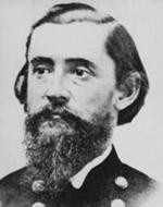
Portrait of Brigadier General George Crook, taken in January 1877 in Cheyenne, Wyoming Territory, by D. S. Mitchell. Reprinted by Private Charles Howard. Wyoming State Archives.
Portrait of Young Man Afraid of His Horses, probably taken in the fall of 1877 at the Red Cloud Agency, Nebraska, by D. S. Mitchell. Reprinted by Private Charles Howard. American Heritage Center.
Native American Photographs
While the majority of Private Howard's surviving images can best be described as outdoor views, including landscapes, he did produce a small number of photographs of Native Americans. All of his surviving Indian photographs were taken outdoors, as opposed to within a studio setting. His earliest is an image of an unidentified Indian, presumably Shoshone, wrapped in a blanket outside Judge Carter's post trader store at Fort Bridger, circa 1875–1877.
The majority of his Native American views are from the Red Cloud and Spotted Tail Agencies, located in northwestern Nebraska, taken in October 1877 while he was part of the Stanton Expedition. He produced a number of views of Indian camps as well as images of prominent Lakota leaders outside their lodge. He photographed Spotted Tail, White Thunder and Two Strike, all prominent Brule headmen. Of the Minneconjou and Sans Arc leaders who had recently surrendered at the Spotted Tail Agency, he was able to photograph Touch the Clouds, Red Bear and Roman Nose. The famed Oglala war leader Crazy Horse had been killed three weeks prior to Private Howard's visit, but the photographer did capture at least two images of Crazy Horse's scaffold grave, located on a bluff overlooking Camp Sheridan.
On his printed list of available views pasted on the back of his stereocards (circa. 1878), Howard advertised that he also had "Numerous Pictures 'Card Size' of Indians of Different Tribes." Many of these may actually be reprints of the work of other photographers.
Related Research Articles
Red Cloud was one of the most important leaders of the Oglala Lakota from 1868 to 1909. He was one of the most capable American Indian opponents that the United States Army faced in its mission to settle the western territories, leading a successful campaign in 1866–68 known as Red Cloud's War over control of the Powder River Country in northeastern Wyoming and southern Montana. The largest action of the war was the Fetterman Fight, with 81 Army soldiers killed, and was the worst military defeat suffered by the army on the Great Plains until the Battle of the Little Bighorn ten years later.
Red Cloud's War was an armed conflict between the Lakota, Northern Cheyenne, and Northern Arapaho on one side and the United States in Wyoming and Montana territories from 1866 to 1868. The war was fought over control of the western Powder River Country in present north-central Wyoming. This grassland, rich in buffalo, was traditionally Crow Indian land, but the Lakota had recently taken control. The Crow tribe held the treaty right to the disputed area, according to the major agreement reached at Fort Laramie in 1851. All involved in "Red Cloud's War" were parties in that treaty.
The Treaty of Fort Laramie was an agreement between the United States and the Oglala, Miniconjou, and Brulé bands of Lakota people, Yanktonai Dakota and Arapaho Nation, following the failure of the first Fort Laramie treaty, signed in 1851.
Crazy Horse was a Lakota war leader of the Oglala band in the 19th century. He took up arms against the United States federal government to fight against encroachment by white American settlers on Native American territory and to preserve the traditional way of life of the Lakota people. His participation in several famous battles of the Black Hills War on the northern Great Plains, among them the Fetterman Fight in 1866 in which he acted as a decoy and the Battle of the Little Bighorn in 1876 in which he led a war party to victory, earned him great respect from both his enemies and his own people.
Little Wolf was a Northern Só'taeo'o Chief and Sweet Medicine Chief of the Northern Cheyenne. He was known as a great military tactician and led a dramatic escape from confinement in Oklahoma back to the Northern Cheyenne homeland in 1878, known as the Northern Cheyenne Exodus.
Henry Beebee Carrington was a lawyer, professor, prolific author, and an officer in the United States Army during the American Civil War and in the Old West during Red Cloud's War. A noted engineer, he constructed a series of forts to protect the Bozeman Trail, but suffered a major defeat at the hands of the warchief Red Cloud.
The Laramie Plains is an arid highland at an elevation of approx. 8,000 feet (2,400 m) in south central Wyoming in the United States. The plains extend along the upper basin of the Laramie River on the east side of the Medicine Bow Range. The city of Laramie is the largest community in the valley. The plains are separated from the Great Plains to the east by the Laramie Mountains, a spur of the Front Range that extends northward from Larimer County, Colorado west of Cheyenne. The high altitude of the region makes for a cold climate and a relatively short growing season. Unsuitable to most cultivation, the plains have historically been used for livestock raising, primarily of sheep and cattle.
The Battle of Powder River, also known as the Reynolds Battle, occurred on Friday, March 17, 1876, in Montana Territory, United States. The attack on a Cheyenne Indian encampment by Colonel Joseph J. Reynolds initiated the Great Sioux War of 1876. Although destroying a large amount of Indian property, the attack was poorly carried out and probably solidified Lakota Sioux and northern Cheyenne resistance to the U.S. attempt to force them to sell the Black Hills and live on a reservation.
Fort Fetterman was a wooden fort constructed in 1867 by the United States Army on the Great Plains frontier in Dakota Territory, approximately 11 miles northwest of present-day Douglas, Wyoming. Located high on the bluffs south of the North Platte River, it served as a major base for the start of several United States military expeditions against warring Native American tribes. The main role of the soldiers was to protect European-American pioneers on the Bozeman Trail. The fort is listed on the National Register of Historic Places.
The Department of the Platte was a military administrative district established by the U.S. Army on March 5, 1866, with boundaries encompassing Iowa, Nebraska, Dakota Territory, Utah Territory and a small portion of Idaho. With headquarters in Omaha, the district commander oversaw the army's role initially along the Overland route to Salt Lake City, then later the construction route of the Union Pacific Railroad. The district also included the Montana road through eastern Wyoming. The district was discontinued when the Army's command was reorganized in 1898.
Daniel Sedgley Mitchell is a famous photographer best known for his series of stereoscopic views of the Black Hills in 1876, his Indian portraits from the Red Cloud Agency in 1877, and his photographs of the Oklahoma Land Rush in 1889.
A subdivision of the Division of the Missouri, the Department of Dakota was established by the United States Army on August 11, 1866 to encompass all military activities and forts within Minnesota, Dakota Territory and Montana Territory. The Department of Dakota was initially headquartered at Fort Snelling, Minnesota, and then moved to St.Paul in March 1867. The department was discontinued in 1911.
William Gentles (c.1830–1878), a private in the U.S. Army, was identified as possibly the soldier who bayoneted the Oglala war leader Crazy Horse in 1877.
James Dempsey Hutton was an artist, surveyor, cartographer and early photographer active in Montana, Wyoming, South Dakota and North Dakota in the years before the American Civil War. He served as an engineer in the Confederate States Army in that conflict, and died in exile in Mexico in 1868.
The Fort Laramie Three-Mile Hog Ranch was built to serve as a social center away from the soldiers' post at historic Fort Laramie. Fort Laramie was a 19th-century military post in eastern Wyoming. It became notorious as a place for gambling and drinking, and for prostitution, with at least ten prostitutes always in residence. The location is notable as an example of one of only a few military bordellos still standing in the United States by 1974, the time of its nomination to the National Register of Historic Places The Fort Laramie site was one of a number of so-called "hog ranches" that appeared along trails in Wyoming.
The Overland Trail was a stagecoach and wagon trail in the American West during the 19th century. While portions of the route had been used by explorers and trappers since the 1820s, the Overland Trail was most heavily used in the 1860s as an alternative route to the Oregon, California, and Mormon trails through central Wyoming. The Overland Trail was famously used by the Overland Stage Company owned by Ben Holladay to run mail and passengers to Salt Lake City, Utah, via stagecoaches in the early 1860s. Starting from Atchison, Kansas, the trail descended into Colorado before looping back up to southern Wyoming and rejoining the Oregon Trail at Fort Bridger. The stage line operated until 1869 when the completion of the First Transcontinental Railroad eliminated the need for mail service via Thais' stagecoach.
The 11th Regiment Cavalry, Ohio Volunteers, known in vernacular as the 11th Ohio Cavalry, was a cavalry regiment raised in the name of the governor of Ohio from several counties in southwest Ohio, serving in the Union Army during the American Civil War. The regiment was stationed in the Dakota and Idaho territories on the American frontier to protect travelers and settlers from raids by American Indians.
The following works deal with the cultural, political, economic, military, biographical and geologic history of pre-territorial Wyoming, Wyoming Territory and the State of Wyoming.
The Big Horn Expedition, or Bighorn Expedition, was a military operation of the United States Army against the Sioux, and Cheyenne Indians in Wyoming Territory and Montana Territory. Although soldiers destroyed one Cheyenne and Oglala Sioux village, the expedition solidified Lakota Sioux and northern Cheyenne resistance against the United States attempt to force them to sell the Black Hills and live on a reservation, beginning the Great Sioux War of 1876.
References
↑ 1870 Census, Scioto Co., Ohio (Microcopy 593 Roll 1265 p. 553), National Archives.
↑ Special Order #137, dated Aug. 20, 1875, Headquarters, General Recruiting Service.
↑ Register of Enlistments, U.S. Army, vol. 74 p. 91 (microcopy 233 roll 39); Regimental Returns and Muster Rolls, 4th Infantry, National Archives.
↑ Bisby to Carter, 1876, private collection. Carter Collection, Wyoming State Archives.
↑ Stanton to Flint, June 14 and June 15, 1877, Press Copies of Letters Sent, Chief of Engineers Records, Department of Platte (RG 393), National Archives.
↑ Details of the expedition's movements is based on "Annual Report of Captain W. S. Stanton, Corps of Engineers, for the Fiscal Year Ending June 30, 1878," Annual Report of the Secretary of War, Appendix RR, serial set volume 1846 (Washington, D.C., 1875.
↑ Private Charles Howard to James Carter, dated "Sydney", Neb., Nov. 3, 1877, Carter Papers, private collection.
↑ Register of Enlistments, loc. cit.; Federal census for 1880, Fort Sanders, Albany Co., Wyoming (T9 roll 1454 p. 54B), National Archives.
Bibliography
"Soldier With a Camera: Private Charles Howard's Photographic Journey Through Eastern Wyoming, 1877," by Ephriam D. Dickson III, Annals of Wyoming, vol. 77 no. 4 (Autumn 2005) pp.22–32.
"Crazy Horse's Grave: A Photograph by Private Charles Howard, 1877," by Ephriam D. Dickson III, Little Big Horn Associates Newsletter, vol. XL, no. 1 (Feb. 2006) pp.4–5.
"Capturing the Lakota Spirit: Photographers at the Red Cloud and Spotted Tail Agencies," by Ephriam D. Dickson III, Nebraska History, vol. 88 no. 1&2 (Spring-Summer 2007) pp.2–25.
"A New Photograph of Crazy Horse's Grave," by Ephriam D. Dickson III, Little Big Horn Associates Newsletter, vol. XLIII, no. 3 (Apr. 2009) pp.4–5. This article discusses a newly discovered photograph of Crazy Horse's scaffold, also taken by Private Charles Howard.
This page is based on this Wikipedia article Text is available under the CC BY-SA 4.0 license; additional terms may apply. Images, videos and audio are available under their respective licenses.


