Thomas Harrison was an English architect and bridge engineer who trained in Rome, where he studied classical architecture. Returning to England, he won the competition in 1782 for the design of Skerton Bridge in Lancaster. After moving to Lancaster he worked on local buildings, received commissions for further bridges, and designed country houses in Scotland. In 1786 Harrison was asked to design new buildings within the grounds of Lancaster and Chester castles, projects that occupied him, together with other works, until 1815. On both sites he created accommodation for prisoners, law courts, and a shire hall, while working on various other public buildings, gentlemen's clubs, churches, houses, and monuments elsewhere. His final major commission was for the design of Grosvenor Bridge in Chester.
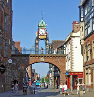
Eastgate and Eastgate Clock in Chester, Cheshire, England, stand on the site of the original entrance to the Roman fortress of Deva Victrix. It is a prominent landmark in the city of Chester and is said to be the most photographed clock in England after Big Ben.
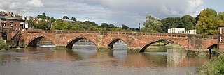
The Old Dee Bridge in Chester, Cheshire, England, is the oldest bridge in the city. It crosses the River Dee carrying the road that leads from the bottom of Lower Bridge Street and the Bridgegate to Handbridge. A bridge on this site was first built in the Roman era, and the present bridge is largely the result of a major rebuilding in 1387. It is recorded in the National Heritage List for England as a designated Grade I listed building, and is a scheduled monument.

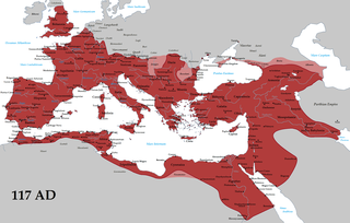
Chester city walls consist of a defensive structure built to protect the city of Chester in Cheshire, England. Their construction was started by the Romans when they established the fortress of Deva Victrix between 70 and 80 AD. It originated with a rampart of earth and turf surmounted by a wooden palisade. From about 100 AD they were reconstructed using sandstone, but were not completed until over 100 years later. Following the Roman occupation nothing is known about the condition of the walls until Æthelflæd refounded Chester as a burgh in 907. The defences were improved, although the precise nature of the improvement is not known. After the Norman conquest, the walls were extended to the west and the south to form a complete circuit of the medieval city. The circuit was probably complete by the middle of the 12th century.

St Peter's Church is in Eastgate Street in the centre of the city of Chester, Cheshire, England, immediately to the north of Chester Cross. It is recorded in the National Heritage List for England as a designated Grade I listed building. It is an active Anglican parish church in the diocese of Chester, the archdeaconry of Chester and the deanery of Chester. The ancient walls mark the boundaries of the parish.
Bridgegate in Chester, Cheshire, England, forms part of the city walls. It is recorded in the National Heritage List for England as a designated Grade I listed building.

The Northgate is in Chester, Cheshire, England, where it carries the city walls footpath over Northgate Street. It is recorded in the National Heritage List for England as a designated Grade I listed building.

The Watergate is in Chester, Cheshire, England and spans the A548 road between Watergate Street and New Crane Street. It forms part of the city walls and carries a footpath over the road. It is recorded in the National Heritage List for England as a designated Grade I listed building.

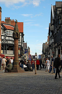
Chester Rows consist of covered walkways at the first floor behind which are entrances to shops and other premises. At street level is another set of shops and other premises, many of which are entered by going down a few steps. The Rows, found in each of the four main streets of the city of Chester, Cheshire, England, are unique.

The Black-and-white Revival was an architectural movement from the middle of the 19th century which re-used the vernacular elements of the past, using timber framing. The wooden framing is painted black and the panels between the frames are painted white. The style was part of a wider Tudor Revival in 19th-century architecture.

The Bridge of Sighs in Chester is a crossing that originally led from the Northgate gaol, across the Chester Canal, to a chapel in the Bluecoat School. It was built to allow condemned prisoners to receive the last rites before their execution. It is recorded in the National Heritage List for England as a designated Grade II listed building.
1 Bridge Street, Chester, is located at the junction of Bridge Street and Eastgate Street at Chester Cross in the centre of the city of Chester, Cheshire, England. Its architecture is that of the black-and-white revival, it incorporates part of the Chester Rows, and is recorded in the National Heritage List for England as a designated Grade II* listed building. Because of its prominent position and its black-and-white architecture, the historian Simon Ward has described it as an "iconic" building.

3–31 Northgate Street is a terrace of shops, offices and a public house on the west side of Northgate Street, Chester, Cheshire, England. All the buildings have a set-back ground floor with a covered walkway, are timber-framed in their upper storeys, and are listed buildings, being graded II* or II. The part of the terrace comprising numbers 5–31 is known as Shoemakers' Row, or Sadler's Row.

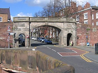
Newgate is an arch bridge carrying the walkway of the city walls over Pepper Street in Chester, Cheshire, England. It is recorded in the National Heritage List for England as a designated Grade II listed building. The bridge was built in 1938 to relieve traffic congestion in the city, especially at Chester Cross. This involved making a new breach in the city walls.
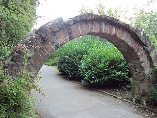
The Shipgate is a sandstone arch standing in Grosvenor Park, Chester, Cheshire, England. It is recorded in the National Heritage List for England as a designated Grade II listed building.
Chester is a city in Cheshire, England. It contains over 650 structures that are designated as listed buildings by English Heritage and included in the National Heritage List for England. Of these, over 500 are listed at Grade II, the lowest of the three gradings given to listed buildings and applied to "buildings of national importance and special interest". This list contains the Grade II listed buildings in the unparished area of the city to the north and west of the Chester city walls.
Chester is a city in Cheshire, England. It contains over 650 structures that are designated as listed buildings by English Heritage and included in the National Heritage List for England. Of these, over 500 are listed at Grade II, the lowest of the three gradings given to listed buildings and applied to "buildings of national importance and special interest". This list contains the Grade II listed buildings in the central unparished area of the city within Chester city walls or located adjacent to them.