Chesterfield Inlet

Last updated
Chesterfield Inlet
Islands near chesterfield inlet.jpg
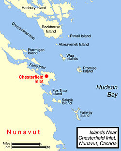
Map of Chesterfield Inlet area.
Location Hudson Bay
Coordinates 63°32′24″N091°04′48″W / 63.54000°N 91.08000°W / 63.54000; -91.08000 (Chesterfield Inlet) Coordinates: 63°32′24″N091°04′48″W / 63.54000°N 91.08000°W / 63.54000; -91.08000 (Chesterfield Inlet)
River sources Thelon River
Basin  countries Canada
Settlements Chesterfield Inlet, Nunavut

Chesterfield Inlet (Inuit: Igluligaarjuk) [1] is an inlet in Kivalliq Region, Nunavut, Canada. It is an arm of northwestern Hudson Bay, and the end point of the Thelon River after its passage through Baker Lake. Cross Bay, a large widening of the inlet, occurs 30 km (19 mi) east of Baker Lake. There are several islands located within the inlet.

Inuit languages Language family

The Inuit languages are a closely related group of indigenous American languages traditionally spoken across the North American Arctic and to some extent in the subarctic in Labrador. The related Yupik languages are spoken in western and southern Alaska and in the far east of Russia, but are severely endangered in Russia today and spoken only in a few villages on the Chukchi Peninsula. The Inuit live primarily in three countries: Greenland, Canada, and the United States.

Inlet An indentation of a shoreline that often leads to an enclosed body of salt water, such as a sound, bay, lagoon, or marsh

An inlet is an indentation of a shoreline, usually long and narrow, such as a small bay or arm, that often leads to an enclosed body of salt water, such as a sound, bay, lagoon, or marsh.

Kivalliq Region region of Nunavut

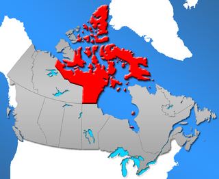
The Kivalliq Region is an administrative region of Nunavut, Canada. It consists of the portion of the mainland to the west of Hudson Bay together with Southampton Island and Coats Island. The regional seat is Rankin Inlet. The population was 10,413 in the 2016 Census, an increase of 16.3% from the 2011 Census.

The first European here may have been William Moor in 1747 who sent boat parties about 60 miles up the inlet. In 1762 William Christopher followed the whole inlet to Baker Lake.

William Moor was a British sailor and explorer associated with the Hudson's Bay Company (HBC) and the annual supply ships to the bay area.

The Inuit hamlet of the same name, Chesterfield Inlet, is situated near the waterway's mouth. In previous times, the area was home to Aivilingmiut and Qaernermiut.

Hamlet (place) small settlement in a rural area

A hamlet is a small human settlement. In different jurisdictions and geographies, hamlets may be the size of a town, village or parish, be considered a smaller settlement or subdivision or satellite entity to a larger settlement. The word and concept of a hamlet have roots in the Anglo-Norman settlement of England, where the old French hamlet came to apply to small human settlements. In British geography, a hamlet is considered smaller than a village and distinctly without a church.

Chesterfield Inlet, Nunavut Hamlet in Nunavut, Canada

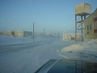
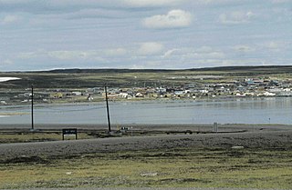
Chesterfield Inlet is a hamlet located on the western shore of Hudson Bay, Kivalliq Region, in Nunavut Canada at the mouth of Chesterfield Inlet. Igluligaarjuk is the Inuktitut word for "place with few houses", it is the oldest community in Nunavut. The community is served by air, Chesterfield Inlet Airport, and by an annual supply known as sealift.

Aivilingmiut ethnic group

The Aivilingmiut are an Inuit people who traditionally have resided north of Hudson Bay in Canada, near Naujaat, Chesterfield Inlet, Southampton Island, and Cape Fullerton. They are descendants of the Thule people and are considered a southern subgroup of the Iglulik Inuit. In the late 19th century, they migrated south to work among American whalers hunting in Hudson Bay.

Related Research Articles

Ukkusiksalik National Park

Ukkusiksalik National Park is a national park in Nunavut, Canada. It covers 20,885 square kilometres (8,064 sq mi) of tundra and coastal mudflats south of the Arctic Circle and the hamlet of Repulse Bay, from Hudson Bay's Roes Welcome Sound towards the western Barrenlands and the source of Brown River. The park surrounds Wager Bay, a 100 kilometres (62 mi)-long inlet on the Hudson Bay. Although the smallest of Nunavut's four national parks, it is the sixth largest in Canada. Its name relates to steatite found there: Ukkusiksalik means "where there is material for the stone pot".

Rankin Inlet Place in Nunavut, Canada

Rankin Inlet is an Inuit hamlet on Kudlulik Peninsula in Nunavut, Canada. Located on the northwestern Hudson Bay, between Chesterfield Inlet and Arviat, it is the regional centre for the Kivalliq Region.

Peter Irniq Canadian politician

Peter Taqtu Irniq is an Inuk politician in Canada, who served as the second Commissioner of Nunavut from April 2000 to April 2005.

Baker Lake, Nunavut Hamlet in Nunavut, Canada

Baker Lake is a hamlet in the Kivalliq Region, in Nunavut on mainland Canada. Located 320 km (200 mi) inland from Hudson Bay, it is near the nation's geographical centre, and is notable for being the Canadian Arctic's sole inland community. The hamlet is located at the mouth of the Thelon River on the shore of Baker Lake. The community was given its English name in 1761 from Captain William Christopher who named it after Sir William Baker, the 11th Governor of the Hudson's Bay Company.

Baker Lake (Nunavut) lake in Nunavut, Canada

Baker Lake is a lake in the Kivalliq Region, Nunavut, Canada. It is fed by the Thelon River from the west and the Kazan River from the south. Its outflows into Chesterfield Inlet. The lake is approximately 1,887 km2 (729 sq mi) in size. It has several named bays, and a few islands.

Thelon River river in the Northwest Territories and Nunavut, Canada

The Thelon River stretches 900 kilometres (560 mi) across northern Canada. Its source is Whitefish Lake in the Northwest Territories, and it flows east to Baker Lake in Nunavut. The Thelon ultimately drains into Hudson Bay at Chesterfield Inlet.

The Indigenous peoples in Northern Canada consist of the First Nations, Métis, and Inuit located in Canada's three territories: Northwest Territories, Nunavut, and Yukon.

Calm Air International LP. is a full service airline, offering passenger, charter and freight services in northern Manitoba and the Kivalliq Region of Nunavut. It is owned by Exchange Income Corporation with its main base in Winnipeg, Manitoba.

Whale Cove, Nunavut Place in Nunavut, Canada

Whale Cove, is a hamlet located 74 km (46 mi) south southwest of Rankin Inlet, 145 km (90 mi) northeast of Arviat, in Kivalliq Region, Nunavut, Canada, on the western shore of Hudson Bay.

Dubawnt Lake lake

Dubawnt Lake is a lake in Kivalliq Region, Nunavut, Canada. It is 3,630 km2 (1,400 sq mi) in size and has several islands. It is about 200 miles north of the point where Manitoba, Saskatchewan and Nunavut come together, about 300 miles west of Hudson Bay and about 250 miles south of the Arctic Circle. To the northwest is the Thelon Wildlife Sanctuary. Its main inlet and outlet is the north-flowing Dubawnt River which joins the Thelon River at Beverly Lake (Nunavut). The Thelon flows east to Hudson Bay at Chesterfield Inlet. It is on the line of contact between the Sayisi Dene band of Eastern Caribou-Eater Chipewyan people and the Harvaqtuurmiut and Ihalmiut bands of Caribou Inuit. The first European to reach the lake was Samuel Hearne in 1770, but it remained largely unknown to outsiders until it was explored by Joseph Tyrrell in 1893. There are no permanent settlements but there are fly-in fish camps where large lake trout can be caught during the 2-month ice-free season.

Demographics of Nunavut

Nunavut is a territory of Canada. It has a land area of 1,877,787.62 km2 (725,017.85 sq mi). In the 2016 census the population was 35,944, up 12.7% from the 2011 census figure of 31,906. In 2006, the latest year for which figures are available, 24,630 people identified themselves as Inuit, 100 as North American Indian (0.3%), 130 Métis (0.4%) and 4,410 as non-aboriginal (15.1%).

Arctic Co-operatives Limited

Arctic Co-operatives Limited is a cooperative federation owned and controlled by 32 community-based cooperative business enterprises located in Nunavut, Northwest Territories, Yukon and northern Manitoba, Canada. Arctic Co-ops coordinates resources, consolidates the purchasing power and provides operational and technical support to the community based co-operatives to enable them to provide a wide range of services to their local member owners. Arctic Co-ops operates in both English and Inuktitut and provides patronage dividends to the local members.

Cape Fullerton

Cape Fullerton is a cape and peninsula in the Kivalliq Region of Nunavut, Canada located on the northwest shores of Hudson Bay on Roes Welcome Sound and includes Fullerton Harbour. Today it is part of Ukkusiksalik National Park. Although Cape Fullerton was traditionally home to migrant Inuit people including the Aivilingmiut and the Qaernermiut, today the nearest permanently populated settlement is Chesterfield Inlet, roughly 100 kilometers to the southwest.

Caribou Inuit, barren-ground caribou hunters, are bands of inland Inuit who lived west of Hudson Bay in Keewatin Region, Northwest Territories, now the Kivalliq Region of present-day Nunavut between 61° and 65° N and 90° and 102° W in Northern Canada. They were originally named "Caribou Eskimo" by the Danish Fifth Thule Expedition of 1921-4 led by Knud Rasmussen. Caribou Inuit are the southernmost subgroup of the Central Inuit.

The locality Tavani (TA-vuh-nee) was a mining settlement and trading post in the Kivalliq Region of Nunavut, Canada. Sometimes known as Tavane, it is located on western Hudson Bay's Mistake Bay, 31.3 km (19.4 mi) south of the community of Whale Cove and 97 km (60 mi) east of Kaminak Lake.

<i>Fort Chesterfield</i> (schooner)

Fort Chesterfield, known as Umiajuatnak by the Inuit, was a Hudson's Bay Company motor schooner which distributed supplies arriving in Chesterfield Inlet to isolated communities along Hudson Bay, including Repulse Bay, Eskimo Point, Coral Harbour, Fullerton Harbour, Wager Bay, and the inland community of Baker Lake, during the 1920s. It established a transportation and communications network for the entire region.

Pitsiulartok

Pitsiulartok or Pituilaktok, is a small, uninhabited island located at 63°15'N, 90°33'W in Hudson Bay, about 13 km from the community of Chesterfield Inlet, Nunavut, Canada. The narrow island is about 3.5 km in length and barely 1 km wide at its widest point. Traditionally it was a walrus-hunting ground for the local Inuit, and a landmark for southern whalers. It is part of a loose chain of small islands running along the coast, including Sakpik Island and Promise Island.

References

  1. Issenman, Betty. Sinews of Survival: The living legacy of Inuit clothing. UBC Press, 1997. pp252-254