Historic Denbighshire is one of thirteen traditional counties in Wales, a vice-county and a former administrative county, which covers an area in north east Wales. It is a maritime county, bounded to the north by the Irish Sea, to the east by Flintshire, Cheshire and Shropshire, to the south by Montgomeryshire and Merionethshire, and to the west by Caernarfonshire.

Wrexham County Borough is a county borough, with the status of a city, in the north-east of Wales. It borders England to the east and south-east, Powys to the south-west, Denbighshire to the west and Flintshire to the north-west. The county borough has a population of 136,055. The city of Wrexham is its largest settlement, which together with villages such as Gwersyllt, New Broughton, Bradley and Rhostyllen form a built-up area with 65,692 residents. Villages in the county borough also include Ruabon, Rhosllanerchrugog, Johnstown, Acrefair, Bangor-on-Dee, and Coedpoeth amongst others. The county borough has two outlying towns, Chirk and Holt, and various rural settlements in the county borough's large salient in the Ceiriog Valley, and the English Maelor.

Wrexham Maelor was one of six local government districts of the county of Clwyd, north-east Wales, from 1974 to 1996.

Glyndŵr was one of six districts of Clwyd between 1974 and 1996.

The Glyn Valley Tramway was a narrow gauge railway that ran through the Ceiriog Valley in north-east Wales, connecting Chirk with Glyn Ceiriog in Denbighshire. The gauge of the line was 2 feet 4+1⁄4 inches (718 mm) while it was horse-drawn, which was unofficially increased to 2 ft 4+1⁄2 in when steam locomotives were introduced. The total length of the line was 8+1⁄4 miles (13.3 km), 6+1⁄2 miles (10.5 km) of which were worked by passenger trains, the remainder serving a large granite quarry and several minor slate quarries.

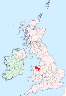
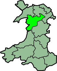
Clwyd South is a constituency of the House of Commons of the Parliament of the United Kingdom (Westminster). The constituency was created in 1997, and it elects one Member of Parliament (MP) by the first past the post method of election.

The Ceiriog Valley is the valley of the River Ceiriog in north-east Wales. Its Welsh name "Dyffryn Ceiriog" is the name of an electoral ward of Wrexham County Borough. The ward is the largest ward of the county borough by area and forms a strikingly-shaped salient of the county borough between Powys and Denbighshire.
Maelor was a rural district in the administrative county of Flintshire, Wales, from 1894 to 1974. The area approximated to the hundred of Maelor or English Maelor, and was notable for forming a detached part of the county, surrounded by Cheshire, Denbighshire and Shropshire. The administrative centre was located at Overton.

Glyn Ceiriog is the principal settlement of the Ceiriog Valley and a community in Wrexham County Borough, north-east Wales. Glyn Ceiriog translates simply as Ceiriog Valley, though there are other villages in the valley. The village and community is technically known, in traditional Welsh naming style, as Llansantffraid Glyn Ceiriog or sometimes Llansanffraid Glyn Ceiriog, which means church of St Ffraid in the Ceiriog Valley, but it has come to be known simply as Glyn Ceiriog, or even Glyn for short. The name Llansanffraid is now more associated with other villages of the same name.

Clwyd South is a constituency of the Senedd. It elects one Member of the Senedd by the first past the post method of election. Also, however, it is one of nine constituencies in the North Wales electoral region, which elects four additional members, in addition to nine constituency members, to produce a degree of proportional representation for the region as a whole.
Ceiriog was a rural district in the administrative county of Denbighshire from 1935 to 1974.
Uwchaled was a rural district in the administrative county of Denbighshire, Wales, from 1894 to 1935. The name denoted the upper reaches of the River Aled, and originated in the medieval cwmwd (commote) of Uwch Aled. The rural district was created by the Local Government Act 1894, and comprised the part of the existing Corwen Rural Sanitary District in Denbighshire.
Aled was a rural district in the administrative county of Denbighshire, Wales, from 1935 to 1974.
Denbigh was a county constituency centred on the town of Denbigh in North Wales. It returned one Member of Parliament (MP) to the House of Commons of the Parliament of the United Kingdom, elected by the first-past-the-post voting system.

Llanarmon Dyffryn Ceiriog is a village in Wrexham County Borough, Wales. It lies on the River Ceiriog and is at the end of the B4500 road, five miles (8 km) south-west of Glyn Ceiriog and ten miles (16 km) north-west of Oswestry. It is within the Ceiriog Valley ward, Clwyd South Senedd constituency and Clwyd South UK parliamentary constituency. It is in the community of Ceiriog Ucha.
Ceiriog Ucha, also spelled as Ceiriog Uchaf, is a community in Wrexham County Borough, Wales. The community lies in the Ceiriog Valley and comprises the villages of Llanarmon Dyffryn Ceiriog and Tregeiriog as well as surrounding farmland and grouse and pheasant moors. It is a rural district set in low hills. The area is governed by Ceiriog Uchaf Community Council, and had a total population of 346, in 129 households, at the 2001 census. reducing to 317 in 2011.

Chirkland was a marcher lordship in north-east Wales. It was created in 1282 from parts of Powys Fadog granted to Roger Mortimer de Chirk, third son of Roger Mortimer, 1st Baron Mortimer of Wigmore, who then built Chirk Castle from where the lordship was administered.
Hiraethog was a rural district of the administrative county of Denbighshire, Wales, from 1935 to 1974. The district took its name from the historic district of Mynydd Hiraethog.
Denbigh District of Boroughs was a parliamentary constituency centred on the town of Denbigh in Wales. It returned one Member of Parliament (MP) to the British House of Commons.
Edeirnion or Edeyrnion is an area of the county of Denbighshire and an ancient commote of medieval Wales in the cantref of Penllyn. According to tradition, it was named after its eponymous founder Edern or Edeyrn. It was included as a Welsh territory of Shropshire in the Domesday Book.