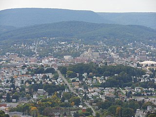
Altoona is a city in Blair County, Pennsylvania. It is the principal city of the Altoona Metropolitan Statistical Area (MSA). The population was 46,320 at the time of the 2010 Census, making it the eleventh most populous city in Pennsylvania. The Altoona MSA includes all of Blair County and was recorded as having a population of 127,089 at the 2010 Census, around 100,000 of whom live within a 5-mile (8.0 km) radius of the Altoona city center according to U.S. Census ZIP Code population data. This includes the adjacent boroughs of Hollidaysburg and Duncansville, adjacent townships of Logan, Allegheny, Blair, Frankstown, Antis, and Tyrone, as well as nearby boroughs of Bellwood and Newry.
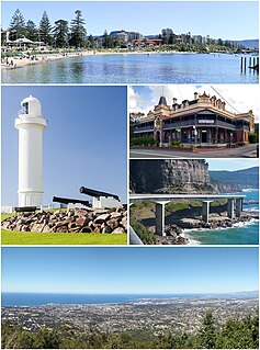
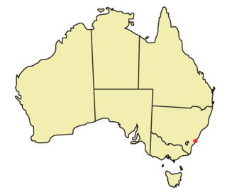
Wollongong, informally referred to as "The Gong", is a city located in the Illawarra region of New South Wales, Australia. The name is thought to be derived from the word woolyungah in the language of the Aboriginal inhabitants at the time of settlement, meaning five islands. Wollongong lies on the narrow coastal strip between the Illawarra Escarpment and the Pacific Ocean, 85 kilometres south of central Sydney. Wollongong had an estimated urban population of 302,739 at June 2018, making it the third-largest city in New South Wales after Sydney and Newcastle and the tenth-largest city in Australia by population. The city's current Lord Mayor is Gordon Bradbery AM who was elected in 2021.

Greenwich Park is a former hunting park in Greenwich and one of the largest single green spaces in south-east London. One of the Royal Parks of London, and the first to be enclosed, it covers 74 hectares, and is part of the Greenwich World Heritage Site. It commands views over the River Thames, the Isle of Dogs and the City of London.

Arncliffe is a suburb in southern Sydney, in the state of New South Wales, Australia. Arncliffe is located 11 kilometres south of the Sydney central business district, in the local government area of the Bayside Council.
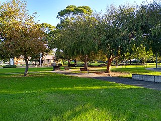
MacCabe Park is a small park located in the City of Wollongong, Australia. It is commonly misspelt McCabe Park, though the sign has since been changed to its correct name. In 1855 a land grant was made to Governor Brown, the present site of the park.

Mount Keira is a suburb and mountain in the Illawarra region of New South Wales, Australia.

Salt Lake City, Utah has many historic and notable sites within its immediate borders. Although the entire Salt Lake City metropolitan area is often referred to as "Salt Lake City", this article is concerned only with the buildings and sites within the official city limits of Salt Lake City.
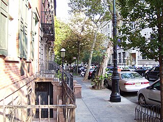
Stuyvesant Street is one of the oldest streets in the New York City borough of Manhattan. It runs diagonally from 9th Street at Third Avenue to 10th Street near Second Avenue, all within the East Village, Manhattan, neighborhood. The majority of the street is included in the St. Mark's Historic District.
This article is about the many neighborhoods and districts in the Greater Richmond, Virginia area. Note that this article is an attempt to be inclusive of the broader definitions of the areas which are often considered part of the Greater Richmond Region, based on their urban or suburban character and nature, rather than by strictly political boundaries.
Puckey's Estate Reserve is a coastal nature reserve in North Wollongong, New South Wales, Australia. It is mainly she-oak forest, but also has sand dune and wetland areas, including areas along Para Creek. It is located in the suburb of Fairy Meadow and is bounded by Fairy Meadow Beach to the east, Squires Way to the west, Elliotts Road to the north and Fairy Lagoon to the south.
Las Vegas Boulevard is a major road in Clark County, Nevada, United States, best known for the Las Vegas Strip portion of the road and its casinos. Formerly carrying U.S. Route 91 (US 91), which had been the main highway between Los Angeles, California and Salt Lake City, Utah, it has been bypassed by Interstate 15 and serves mainly local traffic with some sections designated State Route 604.

Neighborhoods in Spokane, Washington are officially grouped by the Spokane City Council into three main city council districts: 1, 2, and 3. Each city council district contains multiple, official neighborhoods that are recognized with a neighborhood council. Informally, neighborhoods are colloquially grouped by local geographical, geological, cultural, or historical features The list of neighborhoods below is organized based on the official designations by the City of Spokane. Unofficial neighborhoods and districts are listed within the official neighborhood in which they are located.
The city of Wollongong has a distinct geography. It lies on a narrow coastal plain flanked by the Pacific Ocean to the east and a steep sandstone precipice known as the Illawarra Escarpment to the west, most notably Mount Keira, joined to the escarpment by a high saddle.

The city of Davenport, Iowa, United States has neighborhoods dating back to the 1840s. The Davenport Plan and Zoning Commission divided the city into five areas: downtown, central, east end, near north, and northwest and west end. The neighborhoods contain many architectural designs, including Victorian, Queen Anne, and Tudor Revival. Many of the original neighborhoods were first inhabited by German settlers.
State Street is a wide 17.3-mile-long (27.8 km) street in Salt Lake County, Utah leading almost straight south from the steps of the Utah State Capitol Building, through Salt Lake City, South Salt Lake, Millcreek, Murray, eastern Midvale, Sandy, and northwestern Draper. Because it follows the most direct route from downtown Salt Lake City to the Point of the Mountain pass to Utah County, it was the undisputed main road south from Salt Lake City until Interstate 15 (I-15) was built to the west. It retains the U.S. Highway 89 (US-89) designation for all but the northernmost seven blocks despite I-15's proximity. Due to its history as a route for long-distance travel, travel within the Wasatch Front region, and travel between the cities along the east side of the Jordan River, it has attracted a wide variety of retail and service businesses along its entire length, creating a nearly continuous commercial axis for the Salt Lake Valley.
Division Street is a major north–south street in Spokane, Washington, United States. It travels approximately 11 miles (18 km) through a majority of the city, albeit non-contiguously through its southern portions, extending from the South Hill to Spokane's northern border and beyond into Spokane County, where it intersects with the North Spokane Corridor.