Clifford's Fort

Last updated

Gun embrasures on the east wall of the fort Clifford's Fort, N Shields, east wall.jpg
Gun embrasures on the east wall of the fort

Clifford's Fort was a defensive gun battery established near the mouth of the Tyne during the Anglo-Dutch Wars in the 17th century. It subsequently served as a submarine mining depot and survives today as a Scheduled Ancient Monument in the historic Fish Quay area of North Shields, Tyne and Wear, in North East England. [1]

Contents

History

17th century

17th-century west wall with musket ports. A postern to the left originally provided access to the lighthouse. West wall, Clifford's Fort, North Shields.jpg
17th-century west wall with musket ports. A postern to the left originally provided access to the lighthouse.

The fort was built in 1672 at the start of the Third Dutch War. An earlier fort had been established on or near the site some thirty years earlier (a somewhat temporary structure consisting of gabions: "baskets filled with sand and mortar, with guns placed between the baskets") [2] but this had been destroyed in action in 1644. [3] (It was paired with a similar fort on the south bank of the river, which had been established by the Marquis of Newcastle in 1642. [4] )

Modern plaque Cliffords Fort, North Shields. Completed in 1672 and named after Lord Clifford of Cabal, this fort was first armed with 20 x 20 pdr and ten x pdr cannons. Commanded by Governor of Tynemouth Castle until 1839. (4395828776).jpg
Modern plaque

Named after Lord Clifford of Chudleigh ('Clifford of the Cabal'), the new fort was built to the designs of Anglo-Swedish engineer Martin Beckman. It consisted of a raised platform, walled and with a three storey redoubt, protecting a low riverside gun battery, [2] defended to landward by a bastioned trace. [5] It was initially armed with thirty cannons: twenty 20-pounders and ten 10-pounders. [6]

Clifford's Fort was, from its beginnings, associated with the long-established nearby defences of Tynemouth Castle, and the Governor of Tynemouth had oversight of the Fort through until 1839. By the time the fort was built, however, the castle had fallen into a ruinous state and the fort therefore took over as the main defender of the river. [7]

The building of the fort interfered with a lighthouse which had been established on the site by Trinity House of Newcastle-upon-Tyne in 1539, and this remained a point of contention in subsequent decades (not least because the force of the guns, when fired, damaged the lantern). [8]

18th century

Guns on the fort, looking towards Tynemouth Guns on Clifford's Fort, North Shields.jpg
Guns on the fort, looking towards Tynemouth

In the 18th century there was much reconstruction, and the current seaward walls of sandstone ashlar date from that time. [8] By 1720 the redoubt had been reconstructed to serve as a barracks for a company of Invalids (military veterans who helped man the guns), with a gunpowder magazine in the basement (as shown on a map of 1720 now in the British Library). [7] The fort continued to be well-maintained; however the building of a new Governor's House in 1726 obscured the old Low Light, which had to be rebuilt the following year. [8] In 1748 the fort reportedly had "thirty-six 18-pounder guns in three batteries, and a large store of powder within the tower". [9]

19th century

The fort continued in use as a gun battery until the second half of the 19th century, when the building of the Tynemouth piers effectively rendered it obsolete. It was vacated in 1881, but in 1888 the fort became the headquarters of the newly-established Tyne Division Royal Engineers (Volunteers) Submarine Miners [3] The division was one of a number of units around the country responsible for laying and maintaining fixed electro-mechanical mines as port defences. The mines were fired remotely by way of submarine cables, stored in three large tanks alongside the eastern wall of the fort. [10] Several new buildings were established on the site at this time and the old tower or 'keep' was demolished in 1893. At the turn of the century a pair of 6-pounder quick firing guns were installed on the site to defend the minefield. [9]

20th century

In 1907, responsibility for mines having been transferred from the Royal Engineers to the Royal Navy, defensive submarine mining of ports was discontinued (though it was subsequently reinstated, here and elsewhere, for the duration of the First World War). The volunteers at Clifford's Fort were redesignated Tyne Electrical Engineers and given the responsibility of maintaining searchlights for coastal defence. The Electrical Engineers moved out of the fort in 1928, whereupon the site ceased to be a military installation and was acquired by the local authority. [9] It was then given over to serve as a fish processing plant. Several buildings from the submarine mining era were converted at this time; the mine stores and a barrack block became smokehouses [11]

The fort continued to function as an extension to the Fish Quay through the century, though as time went on its surviving fabric suffered, parts of the fortifications being demolished as buildings were added or extended. The Master Gunner's house at the south-west corner of the site, dating from the mid-18th century, was demolished in 1973 to make way for a fish processing unit. [10]

Present day

Buildings on the fort today (left-right): Smokehouses (formerly mine stores), Old Low Light, 'The Barracks' (c.1893) and fishmongers' stalls. Clifford's Fort, N Shields, buildings.jpg
Buildings on the fort today (left-right): Smokehouses (formerly mine stores), Old Low Light, 'The Barracks' (c.1893) and fishmongers' stalls.

Starting in 2008 the remains of the fort were comprehensively restored: a number of modern buildings were removed and the moat was reinstated. [12] In 2013 the fort was removed from the Heritage at Risk Register; [13] this followed a £1 million refurbishment scheme, funded by North Tyneside Council and the Heritage Lottery Fund, which completed the restoration of the fort and brought unused buildings back into use (including the Old Low Light, which opened to the public in 2015 as a museum telling the history of the site). [14]

Related Research Articles

North East England Region of England

North East England is one of nine official regions of England at the first level of ITL for statistical purposes. The region covers an area of 8,592 km2 and in 2019 had a recorded population of nearly 2.7 million. There are four counties in the region: County Durham; Tyne and Wear; Northumberland and part of North Yorkshire. The largest settlements are Newcastle upon Tyne, Middlesbrough, Sunderland, Gateshead and Darlington. There are three conurbations in the region: Tyneside ; Wearside ; and Teesside. Only three settlements in the region have city status: Newcastle upon Tyne, Sunderland and Durham.

Tyne and Wear Metropolitan county in North East England

Tyne and Wear is a metropolitan county in North East England, situated around the mouths of the rivers Tyne and Wear. It came into existence in 1974 after the passage of the Local Government Act 1972, which also created the five metropolitan boroughs of Newcastle upon Tyne, Gateshead, North Tyneside, South Tyneside and the City of Sunderland which constitute the county. It is bordered by Northumberland to the north and Durham to the south. Prior to the 1974 reforms, the area now covered by Tyne and Wear was split between the counties of Northumberland and Durham, the border being marked by the River Tyne. The county no longer has any local government powers, following the disbanding of Tyne and Wear County Council, so the county only exists for ceremonial purposes.

Wallsend Human settlement in England

Wallsend, historically Wallsend on Tyne, is a town in North Tyneside, England. It derives its name from its location at the eastern end of Hadrian's Wall. It has a population of 43,842 and lies 3.5 miles east of Newcastle upon Tyne.

South Tyneside Metropolitan borough in England

South Tyneside is a metropolitan borough in the metropolitan county of Tyne and Wear, North East England.

North Tyneside Metropolitan borough in England

North Tyneside is a metropolitan borough in the metropolitan county of Tyne and Wear, England. It forms part of the greater Tyneside conurbation. North Tyneside Council is headquartered at Cobalt Park, Wallsend.

South Shields Town in Tyne and Wear, England

South Shields is a coastal town in South Tyneside, Tyne and Wear. It is situated at the south of the River Tyne. Historically, it was known to Romans as Arbeia and as Caer Urfa by Early Middle Ages. According to the 2011 census, the town had a population of 75,337. It is the fourth largest settlement in Tyne and Wear; after Newcastle upon Tyne, Sunderland and Gateshead. It is roughly equidistant (approximately 3.7 miles between the border of Newcastle and the border of Sunderland.

Tynemouth Human settlement in England

Tynemouth is a large coastal town and former county borough in the metropolitan borough of North Tyneside in North East England. It is located on the north side of the mouth of the River Tyne, hence its name. Historically part of Northumberland, it is now part of the wider Tyneside conurbation and is best known for Tynemouth Castle and Priory.

North Shields Human settlement in England

North Shields is a coastal town on the north bank of the River Tyne in the North Tyneside borough in Tyne and Wear, North East England. North Shields is 8 miles(13 km) north-east of Newcastle upon Tyne. The town's name derives from Middle English schele meaning "temporary sheds or huts used by fishermen". Historically North Shields was part of the Tynemouth County Borough in Northumberland until 1974, when it became part of Tyne and Wear.

North Shields Fish Quay Port

North Shields Fish Quay is a fishing port located close to the mouth of the River Tyne, in North Shields, Tyne and Wear, North East England, 8 miles (13 km) east of the city of Newcastle upon Tyne.

Shields Ferry

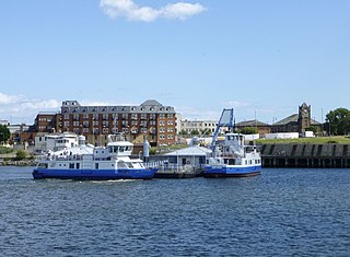
The Shields Ferry operates across the River Tyne, between North Shields and South Shields in Tyne and Wear, England. The service is operated by the Tyne and Wear PTE. Prior to takeover by the PTE in 1972, it was known as the Market Place Ferry.

The North Tyneside Loop refers to the railway lines in North Tyneside from Newcastle upon Tyne via Wallsend, North Shields, Whitley Bay, Backworth, Benton and South Gosforth back to Newcastle. Since the 1980s, it has formed part of the Tyne and Wear Metro, albeit in modified form.

Howdon Place in England

Howdon is a largely residential area in the eastern part of Wallsend, Tyne and Wear, England. It consists of High Howdon and the smaller settlement of East Howdon. Much of the High Howdon area was formerly called Willington prior to post-World War II urbanisation. The North Tyneside ward population at the 2011 Census was 11,129.

Willington Quay is an area in the borough of North Tyneside in Tyne and Wear in northern England. It is situated on the north bank of the River Tyne, facing Jarrow, and between Wallsend and North Shields. It is served by the Howdon Metro station in Howdon. The area from 2006 onwards has been an area of new housing built on brownfield sites. The house building continues into 2013 and is changing the social and economic balance in the area. The area has also had a make over of the bowling green off Howdon Lane and further warehousing next to the bowling green has been demolished to make way for further new housing. The changes made recently at Willington Quay are now making it an attractive place to live within North Tyneside.

Tynemouth Metro station Tyne and Wear Metro station in Tyne and Wear, England

Tynemouth is a Tyne and Wear Metro station, serving the coastal town of Tynemouth, North Tyneside in Tyne and Wear, England. It joined the network as a terminus station on 11 August 1980, following the opening of the first phase of the network, between Haymarket and Tynemouth via Four Lane Ends.

Whitley Bay Metro station Tyne and Wear Metro station in North Tyneside

Whitley Bay is a Tyne and Wear Metro station, serving the coastal town of Whitley Bay, North Tyneside in Tyne and Wear, England. It joined the network on 11 August 1980, following the opening of the first phase of the network, between Haymarket and Tynemouth via Four Lane Ends.

Tyne and Wear Fire and Rescue Service

Tyne and Wear Fire and Rescue Service, formerly known as the Tyne and Wear Metropolitan Fire Brigade, is the fire and rescue service (FRS) for the metropolitan boroughs of Newcastle Upon Tyne, Gateshead, North Tyneside, South Tyneside and Sunderland, serving a population of 1.14 million people across an area of 208 square miles (540 km2). Tyne and Wear Fire and Rescue Authority is responsible for the running of the service, as well as the publication of performance indicators in accordance with its legal obligations. In April 2017, Chris Lowther was appointed chief fire officer.

The Tynemouth Volunteer Artillery claims to be the oldest volunteer artillery unit of the British Army. It served coastal and siege guns in World War I and World War II, and also served in the infantry role.

High and Low Lights of North Shields Lighthouse

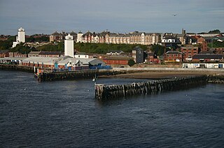
The High and Low Lights of North Shields are decommissioned leading lights in North Shields, Tyne and Wear in the United Kingdom. Two pairs of lights survive: the older pair date from 1727 and were operational until 1810; the newer pair then took over, remaining in use until 1999. All four are listed buildings. They were sometimes known as the Fish Quay High and Low Lights, or as 'Fish Quay ' and 'Dockwray Square '.

The Tyne Electrical Engineers (TEE) is a Volunteer unit of the British Army that has existed under various titles since 1860. It has been the parent unit for a large number of units fulfilling specialist coastal and air defence roles in the Royal Engineers (RE) and Royal Artillery (RA), many seeing service during both World Wars. TEE companies currently form part of the RE and of the Royal Electrical and Mechanical Engineers in the Army Reserve.

Percy Main is a small village absorbed into North Shields, North East England. Historically in Northumberland, it is now part of Tyne and Wear.

References

  1. "Scheduled Ancient Monument listing". Historic England. Retrieved 8 August 2016.
  2. 1 2 "Tyne and Wear Site Lines". North Shields, Clifford's Fort, post medieval defences. Retrieved 8 August 2016.
  3. 1 2 "North Shields: an archaeological assessment and strategy" (PDF). Tyne & Wear Historic Towns Survey. Newcastle City Council. Retrieved 7 August 2016.
  4. "North Shields, small fort". Tyne and Wear SiteLines (Historic Environment Record). Newcastle City Council. Retrieved 13 September 2016.
  5. Saunders, Andrew (1989). Fortress Britain: artillery fortification in the British Isles and Ireland. Liphook, Hants.: Beaufort. p. 101.
  6. England, Bolckow from Middlesbrough (27 February 2010), Headquarters of Tyne Division Royal Engineers (Volunteers) Submarine Miners 1888 – 1928. , retrieved 26 February 2022
  7. 1 2 "A Plan of Tinmouth Town and Castle and Clifford Fort, scituate at the Entrance of the River Tine". British Library. Retrieved 8 August 2016.
  8. 1 2 3 Pevsner; et al. (1992) [1957]. The Buildings of England: Northumberland. London: Penguin Books.
  9. 1 2 3 "Clifford's Fort". The Fish Quay, North Shields. Archived from the original on 8 March 2016. Retrieved 8 August 2016.
  10. 1 2 "Historic fort's past revealed". North Tyneside Strategic Partnership. Retrieved 8 August 2016.[ permanent dead link ]
  11. "Listed building description". Historic England. Retrieved 8 August 2016.
  12. "Historic Fort is restored". BBC. Retrieved 8 August 2016.
  13. "Heritage at Risk". North Tyneside Council. Retrieved 8 August 2016.
  14. "Fish Quay Townscape Heritage Initiative". North Tyneside Council. Retrieved 8 August 2016.

Coordinates: 55°00′35″N1°26′01″W / 55.0098°N 1.4335°W / 55.0098; -1.4335