J D Wetherspoon plc is a pub company in the United Kingdom and Ireland. Founded in 1979 by Tim Martin, the company operates nearly 900 pubs, including the chain of Lloyds No.1 bars, and a growing number of Wetherspoon hotels. With its headquarters in Watford, Wetherspoon is known for converting unconventional yet attractive premises into pubs. The company is listed on the London Stock Exchange and is a constituent of the FTSE 250 Index.

The Angel, Islington is a historic landmark and a series of buildings that have stood on the corner of Islington High Street and Pentonville Road in Islington, London, England. The land originally belonged to the Clerkenwell Priory and has had various properties built on it since the 16th century. The site was bisected by the New Road, which opened in 1756, and properties on the site have been rebuilt several times up to the 20th century. The corner site gave its name to Angel tube station, opened in 1901, and the surrounding Angel area of London.

Roa Island lies just over half a mile (1 km) south of the village of Rampside at the southernmost point of the Furness Peninsula in Cumbria, though formerly in the County of Lancashire north of the sands. It is located at 54°5′N3°10′W. It is one of the Islands of Furness in northern England. It has an area of about three hectares.

Roose or Roosecote is a suburb and ward of Barrow-in-Furness, Cumbria, England. The word 'roose' is Celtic for "moor" or "heath" and the suffix 'cote' of Roosecote means "hut" or "huts". Before the building of Roose Cottages and the arrival of the Cornish miners Roose was pronounced with a hard S, as in goose; now it is locally pronounced 'Rooze', due to the Cornish accent. Roose is served by Roose railway station, one of the few remaining stations on the Furness Line in the Barrow area.

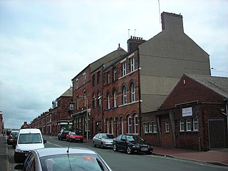
Barrow Island, commonly know locally as Baz I is an area and electoral ward of Barrow-in-Furness, Cumbria, England. Originally separate from the British mainland, land reclamation in the 1860s saw the northern fringes of the island connect to Central Barrow. Barrow Island is also bound to the south and east by the town's dock system and to the west by Walney Channel. The Ward population taken at the 2011 census was 2,616.
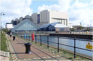
The Dock Museum is situated in Barrow-in-Furness, Cumbria, England. Most of its exhibits concern the history of the town, focusing on the shipbuilding industry at VSEL, the steelworks industry — of which Barrow once had the world's largest, the Furness Railway and the World War II bombings of the town. There has been a museum in Barrow since 1907 and in its current location since 1994, when 50,000 people visited it in its first year, visitor numbers peaked at 120,000 in 2001. The museum has free entry and remains under public ownership.
Hindpool is an area and electoral ward of Barrow-in-Furness, Cumbria, England. It is bordered by Barrow Island, Central Barrow, Ormsgill, Parkside and the Walney Channel, the local population stood at 5,851 in 2011. The ward covers the entire western half of the town centre and includes Barrow's main shopping district. Other local landmarks include the Furness College Channelside campus, the Dock Museum and the Main Public Library. Hindpool is also home to two stadia - Barrow Raiders' Craven Park and Barrow A.F.C.'s Holker Street.
The Port of Barrow refers to the enclosed dock system within the town of Barrow-in-Furness, England. Morecambe Bay is to the east of the port and the Irish Sea surrounds it to the south and west. The port is currently owned and operated by Associated British Ports Holdings, but some land is shared with BAE Systems Submarine Solutions. Currently consisting of four large docks, the Port of Barrow is one of North West England's most important ports. The docks are as follows: Buccleuch Dock, Cavendish Dock, Devonshire Dock and Ramsden Dock. The port of Barrow is the only deep water port between the Mersey and the Clyde.
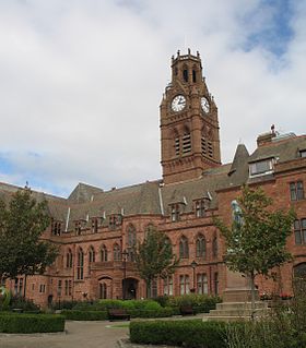
Barrow-in-Furness Town Hall is a Victorian-era, neo-gothic municipal building in Barrow-in-Furness, Cumbria, England. The building serves as the base of Barrow Borough Council.

Furness Academy is a secondary school in Barrow-in-Furness, England. It is the fourth and last academy to have been formed in the county of Cumbria after the closure of Alfred Barrow School, Parkview Community College of Technology and Thorncliffe School in 2009. Having utilised numerous buildings of the former Parkview and Thorncliffe Schools since 2009, a single £22 million building opened in the Parkside area of the town in September 2013.

The Furness Abbey Hotel, now a public house named The Abbey Tavern, stands in Abbey Approach, Barrow-in-Furness, Cumbria, England, to the north of the remains of Furness Abbey. The current structure is recorded in the National Heritage List for England as a designated Grade II listed building.
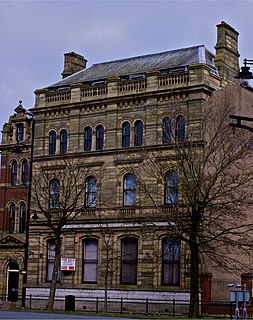
The National Westminster Bank building in Barrow-in-Furness, Cumbria, England is located at the intersection of Abbey Road and Duke Street. It was designed by Paley and Austin architects and built between 1873-74 and has been designated a Grade II listed building by English Heritage. Built for the Lancaster branch of the National Westminster Bank it was a major component of the Ramsden Square scheme, one of the planned town's two main squares and focal points. It is one of three former 'Nat West' properties with listed building status in the Borough and currently houses a carpet shop in the lower floors.
Furness Abbey is a former railway station in the Barrow-in-Furness area of the Furness Peninsula, England.

St. George's Square, in Barrow-in-Furness, Cumbria, England is a public space that acted as the centre of the town during the late-19th Century. The square now lies in the southernmost fringes of the Central ward close to the Port of Barrow.

Oxford Chambers is a Grade II listed building located on Abbey Road in Barrow-in-Furness, Cumbria, England. Oxford Chambers was constructed in 1875 with the intention of it functioning as a commercial property, however the new town's first higher grades school opened within the building in 1880. The school relocated to a larger premises on Duke Street in 1889. A notable feature of the building is a sign reading 'Central Cigar Depot', it also housed a shop selling office supplies in the late 20th century. Despite this, it is most known for containing the extension of the adjacent Travellers Rest social club. Oxford Chambers lies at the very northern perimeter of the Central Barrow conservation area close to The Duke of Edinburgh Hotel and the neighbouring Cooke's Building.

Barrow-in-Furness Strand railway station was the first permanent railway terminus to be built in Barrow-in-Furness, England. Located on the Strand at St. George's Square close to the town's docks its functioning life was short, however the building itself continued to be used as the headquarters of the Furness Railway for a number of years. The station opened in 1863 having replaced a wooden structure which was erected in 1846 at adjacent Rabbit Hill. The station at St. George's square ceased commercial operations in 1882 upon the completion of a new loop line and much larger station at Abbey Road. Barrow-in-Furness Central railway station, later simply renamed Barrow-in-Furness railway station has been the town's primary station ever since.
Rampside railway station was located on the Piel Branch of the Furness Railway in the Rampside area of Barrow-in-Furness, England. Opened in 1846 as Concle station, it was renamed Rampside station in 1869. The station remained operational until 1936 when it closed along with the following station at Piel, which had been reachable via the Roa Island Causeway. The station building and entire branch line had been demolished by the 1980s.

Piel railway station was the terminus of the Furness Railway's Piel Branch in Barrow-in-Furness, England that operated between 1846 and 1936. Located on Roa Island it was built to serve the passenger steamers at Piel Pier. The Roa Island causeway was specifically constructed for the railway, in turn making the island part of the British mainland. The station and the Piel Branch line have both been demolished, however the Roa Island Hotel which was built adjoining the station survives to this day as a Grade II listed building.

The Majestic Hotel located at Schneider Square in Barrow-in-Furness, Cumbria, England is a 3-star Grade II listed hotel constructed in 1904. The building was designed by JY McIntosh and contains elements of Edwardian and Jacobean architecture. It is also noted for its striking rounded Flemish gables. £1.7 million was spent on refurbishing the hotel in 2008 by developers One Leisure, although ownership of the Majestic, and its nearby sister hotel the Imperial, have since been transferred. The majority of the building's ground floor level is occupied by an Italian restaurant named Francesca's.


