
The Tödi, is a mountain massif and with the mountain peak Piz Russein the highest mountain in the Glarus Alps and the highest summit in the canton of Glarus, Switzerland. It is located on the border between the cantons of Graubünden, to the south, and Glarus, to the north, close to the point where those two cantons meet the canton of Uri, to the west. Although not the culminating point of Graubünden, it is its highest peak outside the Bernina range.
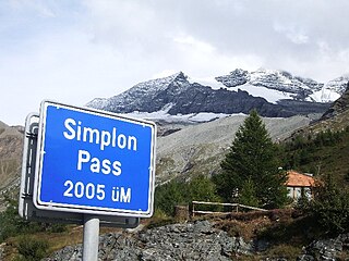
The Simplon Pass is a high mountain pass between the Pennine Alps and the Lepontine Alps in Switzerland. It connects Brig in the canton of Valais with Domodossola in Piedmont (Italy). The pass itself and the villages on each side of it, such as Gondo, are in Switzerland. The Simplon Tunnel was built beneath the vicinity of the pass in the early 20th century to carry rail traffic between the two countries.

The Bernina Pass is a high mountain pass in the Bernina Range of the Alps, in the canton of Graubünden (Grisons) in eastern Switzerland. It connects the famous resort town of St. Moritz in the Engadin valley with the Italian-speaking Val Poschiavo, which ends in the Italian town of Tirano in Valtellina. The pass lies a few kilometres east of Piz Bernina, and south of Val Minor.

Lukmanier Pass is a pass in the Swiss Alps.
The Flüela Pass is a high mountain pass of the Swiss Alps in Graubünden. Traditionally considered the boundary between the Albula and Silvretta Alps, the pass crosses the watershed / drainage divide between the basins of the Rivers Rhine and Danube. The pass is overlooked by the Flüela Schwarzhorn and the Flüela Wisshorn. The summit of the pass lies between the lakes Lai da la Scotta and Lai Nair.

Fuorn Pass or Ofen Pass is a high alpine mountain pass in the canton of Graubünden in Switzerland. The name is based on the ovens that were used in ironworks in the area. The ruins of these ovens can still be seen from nearby trails.

Maloja Pass is a high mountain pass in the Swiss Alps in the canton of Graubünden, linking the Engadine with the Val Bregaglia, still in Switzerland and Chiavenna in Italy. It marks the divide between the Danube and Po watersheds. Lägh da Bitabergh is near the pass.

Furka Pass, with an elevation of 2,429 metres (7,969 ft), is a high mountain pass in the Swiss Alps connecting Gletsch, Valais with Realp, Uri. The Furka Oberalp Bahn line through the Furka Tunnel bypasses the pass. The base tunnel opened in 1982 and replaced a tunnel at 2100 m.

Oberalp Pass is a high mountain pass in the Swiss Alps connecting the cantons of Graubünden and Uri between Disentis and Andermatt.

Susten Pass is a mountain pass in the Swiss Alps. The pass road, built from 1938–1945, connects Innertkirchen in the canton of Bern with Wassen in the canton of Uri. A 300-metre long tunnel crosses the pass at 2,224 metres.
San Bernardino Pass is a high mountain pass in the Swiss Alps connecting the Hinterrhein and the Mesolcina (Misox) valleys between Thusis and Bellinzona. Located in the far eastern side of the Western Alps it is not to be confused with the Great St Bernard Pass and the Little St Bernard Pass. The top of the pass represents both the Italo-German language frontier and the watershed between the Po basin and the Rhine basin. Marscholsee is within the pass at an elevation of 2,053 m (6,736 ft).

The Alps cover a large area. This article describes the delimitation of the Alps as a whole and of subdivisions of the range, follows the course of the main chain of the Alps and discusses the lakes and glaciers found in the region.
Piz Kesch (German) or Piz d'Es-cha (Rumantsch) is a peak in the Albula Alps of the Rhaetian Alps in Switzerland. At 3,418 metres (11,214 ft), it is the highest peak in the Albula Alps and the municipality of Bergün, Grisons.
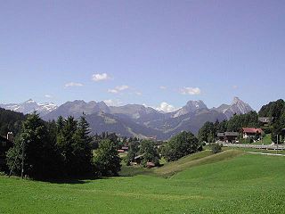
Saanenmöser is a high mountain pass in the Bernese Oberland in the Alps in Switzerland.

The Schwyz Alps are a mountain range in Switzerland. They form part of the North-Eastern Swiss Alps and are bordered by the Glarus Alps to the east, the Appenzell Alps to the north-east, the Emmental Alps in the west, and the Uri Alps to the south-west. The Klausen Pass is the highest point between the Schwyz Alps and the Glarus Alps.

