Cold River (Vermont)

Last updated
Cold River
River
Country United States
State Vermont
Counties Rutland
Towns/Cities Shrewsbury, Clarendon, Rutland (town)
Source
 - location Shrewsbury, Vermont
 - elevation 2,120 ft (646 m)
 - coordinates 43°32′30″N72°48′43″W / 43.54164°N 72.81198°W / 43.54164; -72.81198
Mouth Otter Creek
 - location Rutland (town), Vermont
 - elevation 530 ft (162 m)
 - coordinates 43°34′23″N72°59′11″W / 43.57312°N 72.98630°W / 43.57312; -72.98630 Coordinates: 43°34′23″N72°59′11″W / 43.57312°N 72.98630°W / 43.57312; -72.98630
Length 20.7 km (13 mi)

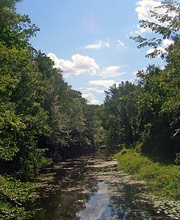
The Cold River is a 12.9-mile-long (20.8 km) [1] tributary of Otter Creek in Rutland County, Vermont, in the United States.

Otter Creek (Vermont) tributary of Lake Champlain in Vermont, United States of America

Otter Creek is one of the major streams located in the state of Vermont. Roughly 112 miles (180 km) in length, it is the primary stream running through Rutland County and Addison County. It is one of the largest rivers in the state.

Rutland County, Vermont County in the United States

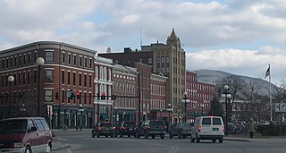
Rutland County is a county located in the U.S. state of Vermont. As of the 2010 census, the population was 61,642, making it the second-most populous county in Vermont. Its county seat and most populous municipality is the city of Rutland. It is named after the English county of Rutland.

Vermont State of the United States of America

Vermont is a state in the New England region of the northeastern United States. It borders the U.S. states of Massachusetts to the south, New Hampshire to the east, New York to the west, and the Canadian province of Quebec to the north. Vermont is the second-smallest by population and the sixth-smallest by area of the 50 U.S. states. The state capital is Montpelier, the least populous state capital in the United States. The most populous city, Burlington, is the least populous city to be the most populous city in a state. As of 2015, Vermont was the leading producer of maple syrup in the United States. In crime statistics, it was ranked as the safest state in the country in 2016.

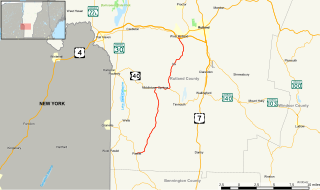
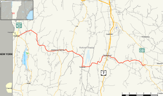
The Cold River rises northeast of North Shrewsbury in the Coolidge Range, part of the Green Mountains. It flows southwest through North Shrewsbury, then turns northwest to the town line with Clarendon, where it turns west and flows through the village of North Clarendon. It reaches Otter Creek 1 mile (2 km) west of North Clarendon, just north of the Rutland town line.

Green Mountains mountain range in Vermont, U.S.

The Green Mountains are a mountain range in the U.S. state of Vermont. The range runs primarily south to north and extends approximately 250 miles (400 km) from the border with Massachusetts to the border with Quebec, Canada. The part of the same range that is in Massachusetts and Connecticut is known as The Berkshires or the Berkshire Hills and the Quebec portion is called the Sutton Mountains, or Monts Sutton in French.

The Cold River is crossed by the Appalachian Trail and by U.S. Route 7.

Appalachian Trail Hiking trail in the USA

The Appalachian National Scenic Trail, generally known as the Appalachian Trail or simply the A.T., is a marked hiking trail in the Eastern United States extending between Springer Mountain in Georgia and Mount Katahdin in Maine. The trail is about 2,200 miles (3,500 km) long, though the exact length changes over time as parts are modified or rerouted. The Appalachian Trail Conservancy describes the Appalachian Trail as the longest hiking-only trail in the world. More than 2 million people are said to take a hike on part of the trail at least once each year.

U.S. Route 7 highway in the United States

U.S. Route 7 (US 7) is a north–south United States highway in western New England that runs for 308 miles (496 km) through the states of Connecticut, Massachusetts, and Vermont. The highway's southern terminus is at Interstate 95 (I-95) exit 15 in Norwalk, Connecticut. Its northern terminus is at I-89 exit 22 near the village of Highgate Springs, Vermont, immediately south of the Canada–US border.

See also

Related Research Articles

Clarendon, Vermont Town in Vermont, United States

Clarendon is a town in Rutland County, Vermont, United States. The population was 2,571 at the 2010 census. Clarendon spans U.S. Route 7 and is split by the highway, the Cold River and Mill River, Otter Creek, and the Green Mountains into the villages of Clarendon, West Clarendon, East Clarendon, Clarendon Springs, and North Clarendon

Middlebury, Vermont Town in Vermont, United States

Middlebury is the shire town of Addison County, Vermont, United States. The population was 8,496 at the 2010 census. Middlebury is home to Middlebury College and the Henry Sheldon Museum of Vermont History.

Rutland (city), Vermont City in Vermont, United States

The city of Rutland is the seat of Rutland County, Vermont, United States. As of the 2010 census, the city had a total population of 16,495. It is located approximately 65 miles (105 km) north of the Massachusetts state line and 20 miles (32 km) east of the New York state line. Rutland is the third largest city in the state of Vermont after Burlington and South Burlington. It is surrounded by the town of Rutland, which is a separate municipality. The downtown area of the city is listed as a historic district on the National Register of Historic Places.

West Rutland, Vermont Town in Vermont, United States

West Rutland is a town in Rutland County, Vermont, United States. The population was 2,326 at the 2010 census. The town center, located in the south central portion of the town and where about 87% of the population resides, is defined by the U.S. Census Bureau as a census-designated place (CDP). The town is part of the Rutland micropolitan NECTA.

Vermont Route 103 highway in Vermont

Vermont Route 103 is a north–south state highway in southern Vermont, United States. It runs from Rockingham in the east to Clarendon near Rutland in the west. The Vermont Country Store's second branch is one attraction along the route, as well as the Okemo Ski Resort in Ludlow.

Vermont Route 133 highway in Vermont

Vermont Route 133 is a 22.476-mile (36.172 km) north–south state highway in Rutland County, Vermont, United States. It runs from Pawlet in the south to West Rutland in the north.

West River (Vermont) river in the United States of America

The West River is a tributary of the Connecticut River, about 53.8 miles (86.6 km) long, in southern Vermont in the United States. According to the Geographic Names Information System, it has also been known historically as "Wantastiquet" and as "Waters of the Lonely Way". Its watershed covers 423 square miles; land use is about 90% forested and 3% agricultural, and the upper river supports wild native brook and wild brown trout, while Atlantic salmon occur in most of the river.

The Vermont Railway is a shortline railroad in Vermont and eastern New York, operating much of the former Rutland Railway. It is the main part of the Vermont Rail System, which also owns the Green Mountain Railroad, the Rutland's branch to Bellows Falls. The trackage is owned by the Vermont Agency of Transportation except in New York, where VTR operates a line owned by the Boston and Maine Corporation. The rail line employs about 150 people in Vermont.

Codorus Creek is a 42.4-mile-long (68.2 km) tributary of the Susquehanna River in York County, Pennsylvania in the United States.

Batten Kill river in the United States of America

The Batten Kill, Battenkill, or Battenkill River is a 59.4-mile-long (95.6 km) river rising in Vermont that flows into New York and is a tributary of the Hudson River. As "kill" means a creek, the name "Battenkill River" is pleonastic.

The White River is a 60.1-mile-long (96.7 km) river in the U.S. state of Vermont. It is a tributary of the Connecticut River.

Shrewsbury Peak is a mountain located in Rutland County, Vermont, in the Calvin Coolidge State Forest. The mountain is part of the Coolidge Range. Shrewsbury is flanked to the northwest by Little Killington.

Otter Kill river in the United States of America

Otter Kill is a 16.0-mile-long (25.7 km) tributary of Moodna Creek that flows through central Orange County, New York, in the United States. Via the Moodna, which it forms at a confluence with Cromline Creek north of the village of Washingtonville, its waters eventually reach the Hudson River.

Mill River (Otter Creek tributary) river in the United States of America

The Mill River is a 17.8-mile-long (28.6 km) tributary of Otter Creek in Rutland County, Vermont, in the United States.

Vermont Route 140

Vermont Route 140 (VT 140) is a state highway in the U.S. state of Vermont. The highway runs 25.059 miles (40.329 km) from VT 30 in Poultney east to VT 103 in Mount Holly. VT 140 connects the southern Rutland County towns of Poultney, Middletown Springs, Tinmouth, Wallingford, and Mount Holly.

Cold River Bridge (Clarendon, Vermont) historic bridge in Vermont, United States

The Cold River Bridge was a historic bridge that carried Vermont Route 7B (VT 7B) across the Cold River in Clarendon, Vermont. The bridge, a steel Parker through truss, was built by the American Bridge Company in 1928, and was one of many bridges built in the state in the wake of devastating 1927 floods. It carried U.S. Route 7 (US 7) until bypassed by a bridge to the east, and was closed in 1989. It was listed on the National Register of Historic Places in 1991. It was subsequently demolished after a report noting substantial failures.

North Clarendon, Vermont Village in Vermont, United States

North Clarendon is an unincorporated village in the town of Clarendon, Rutland County, Vermont, United States. The community is located along U.S. Route 7 and the Cold River, 3 miles (4.8 km) south of Rutland. North Clarendon has a post office with ZIP code 05759.

References

  1. U.S. Geological Survey. National Hydrography Dataset high-resolution flowline data. The National Map Archived 2012-04-05 at WebCite , accessed December 9, 2011