Grenada is an island country located between the Caribbean Sea and Atlantic Ocean, north of Trinidad and Tobago. It is located at 12°07′N61°40′W. There are no large inland bodies of water on the island, which consists entirely of the state of Grenada. The coastline is 121 km long. The island has 15 constituencies and speaks English and Grenadian Creole. It is volcanic in origin and its topography is mountainous.

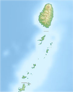
Saint Vincent and the Grenadines, often simply referred to as Saint Vincent, is an island country in the Caribbean. It is located in the southeast Windward Islands of the Lesser Antilles, which lie in the West Indies at the southern end of the eastern border of the Caribbean Sea where the latter meets the Atlantic Ocean.

Basseterre is the capital and largest city of Saint Kitts and Nevis with an estimated population of 14,000 in 2018. Geographically, the Basseterre port is located at 17°18′N62°44′W, on the south western coast of Saint Kitts Island, and it is one of the chief commercial depots of the Leeward Islands. The city lies within Saint George Basseterre Parish.

Saint Vincent is a volcanic island in the Caribbean. It is the largest island of the country Saint Vincent and the Grenadines island chain and is located in the Caribbean Sea, between Saint Lucia and Grenada. It is composed of partially submerged volcanic mountains. Its largest volcano and the country's highest peak, La Soufrière, is active, with the latest episode of volcanic activity having begun in December 2020 and intensifying in April 2021.

Cape Vincent is a town in Jefferson County, New York, United States. The population was 2,777 at the 2010 census.
The Leeward Islands are a group of islands situated where the northeastern Caribbean Sea meets the western Atlantic Ocean. Starting with the Virgin Islands east of Puerto Rico, they extend southeast to Guadeloupe and its dependencies. In English, the term Leeward Islands refers to the northern islands of the Lesser Antilles chain. The more southerly part of this chain, starting with Dominica, is called the Windward Islands. Dominica was originally considered part of the Leeward Islands, but was transferred from the British Leeward Islands to the British Windward Islands in 1940.
The Windward Islands, also known as the Islands of Barlovento, are the southern, generally larger islands of the Greater Antilles, within the West Indies. They lie south of the Leeward Islands, approximately between latitudes 10° and 16° N and longitudes 60° and 62° W. The name was also used to refer to a British colony in these islands, existing between 1833 and 1960 and consisting of the islands of Saint Lucia, Saint Vincent, the Grenadines, and Grenada, which today make up three sovereign nations. The island of Dominica, also today a sovereign nation, was traditionally a part of the Leeward Islands until 1940, when it was transferred from the Leeward Islands colony to the Windward Islands.
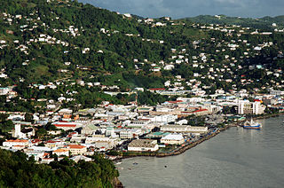
Kingstown is the capital, chief port, and main commercial centre of Saint Vincent and the Grenadines. With a population of 12,909 (2012), Kingstown is the most populous settlement in the country. It is the centre for the island's agricultural industry and a port of entry for tourists. The city lies within the parish of Saint George in the south-west corner of Saint Vincent.
Saint Vincent may refer to:
The parish of Saint Lucy is the northernmost area in the country of Barbados. Saint Lucy is the only parish of Barbados out of the eleven to be named after a female patron saint, Saint Lucy of Syracuse. Saint Lucy's shape also resembles a peninsula, surrounded on three sides by the Atlantic Ocean to the north, east and west. The Harrison Point Lighthouse is located in Harrisons, Saint Lucy between Great Head and Norse's Bay, also in Saint Lucy. To the south lies the neighbouring Parish of Saint Peter.

UTC−04:00 is an identifier for a time offset from UTC of −04:00. It is observed in the Eastern Time Zone during the warm months of daylight saving time, as Eastern Daylight Time. The Atlantic Time Zone observes it during standard time . It is observed all year in the Eastern Caribbean and several South American countries.

Charlotte is the largest parish of Saint Vincent and the Grenadines, situated on the eastern coast of the island of Saint Vincent. With an area of 149 km², its size is comparable to that of the British Virgin Islands.) The parish has the longest coastline of all the parishes and is also larger than the three smallest parishes combined. The parish possesses a very rough and rugged topography with very little flat land occurring towards the coast. as a result of these features, parts of the north of the parish cannot be accessed by a main road. Up until the building of a bridge over the Rabacca Dry River access to the north side of the river was not possible when rain caused the river to swell and make the path impassable.

Apalachicola Bay is an estuary and lagoon located on the northwest coast of the U.S. state of Florida. The Apalachicola Bay system also includes St. George Sound, St. Vincent Sound and East Bay, covering an area of about 208 square miles (540 km2). Four islands, St. Vincent Island to the west, Cape St. George Island and St. George Island to the south, and Dog Island to the east, separate the system from the Gulf of Mexico. Water exchange occurs through Indian Pass, West Pass, East Pass and the Duer Channel. The lagoon has been designated as a National Estuarine Research Reserve and the Apalachicola River is the largest source of freshwater to the estuary. Combined with the Chattahoochee River, Flint River, and Ochlockonee River they drain a watershed of over 20,000 square miles (50,000 km2) at a rate of 19,599 cubic feet (550 m3) per second according to the United States Geological Survey in 2002.
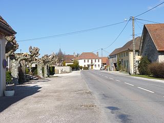
Aubigny-en-Plaine is a commune in the Côte-d'Or department in the Bourgogne-Franche-Comté region of eastern France.
Ally is a commune in the Cantal department in the Auvergne region of south-central France.

Argiusta-Moriccio is a commune in the Corse-du-Sud department of France on the island of Corsica.
The following outline is provided as an overview of and topical guide to Saint Vincent and the Grenadines: