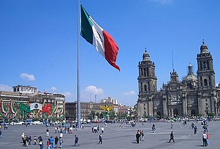
Cuauhtémoc, named after the former Aztec leader, is one of the 16 boroughs of Mexico City. It consists of the oldest parts of the city, extending over what was the entire city in the 1920s. This area is the historic and cultural center of the city, although it is not the geographical center. While it ranks only sixth in population, it generates about a third of the entire city's GDP, mostly through commerce and services. It is home to the Mexican Stock Exchange, the important tourist attractions of the historic center and Zona Rosa, and various skyscrapers such as the Torre Mayor and the Mexican headquarters of HSBC. It also contains numerous museums, libraries, government offices, markets and other commercial centers which can bring in as many as 5 million people each day to work, shop or visit cultural sites. This area has had problems with urban decay, especially in the historic center. Efforts to revitalize the historic center and some other areas have been ongoing since the 1990s, by both government and private entities. Such efforts have resulted in better public parks, such as the Alameda Central, which was renovated; the modification of streets such as 16 de Septiembre and Madero that have become exclusive for pedestrians.

Metro Chabacano is a station on Lines 2, 8 and 9 of the Mexico City Metro system. It is located in the Cuauhtémoc borough of Mexico City, south of the city centre, on Calzada de Tlalpan.

Colonia Obrera is an administrative neighborhood of the borough of Cuauhtémoc in the center of Mexico City. It was established in the late 19th and early 20th centuries and became home to many artisans and industrial workmen. Up to the early 1980s, a number of sewing factories were still located here, but the 1985 Mexico City earthquake destroyed many, including the Topeka factory in which many of the seamstresses died inside. Today, the area has a high crime rate but there have been efforts to revitalize it.
Colonia Ampliación Asturias is a neighborhood in the Cuauhtémoc borough of Mexico City. It is located southeast of the historic center of Mexico City. It borders are marked by the following streets, to the north Eje Tres Sur or Avenida Calzada del Chabacano, Calzada de la Viga to the east, Calzada de San Antonio Abad to the west and Hernandez Davalos street to the south.

Colonia Atlampa is a colonia or neighborhood located in the Cuauhtémoc borough, northwest of the historic center of Mexico City. The boundaries of the area are marked by the following streets: Calzada de Nonoalco or Ricardo Flores Magón Street to the south, Circuito Interior Paseo de las Jacarandas to the north, Avenida Insurgentes Norte to the east and Circuito Interior Instituto Politécnico Industrial to the west. The neighborhood is considered lower class and working class. The name is derived from a Nahuatl phrase meaning "where the water divides."

Colonia Buenavista is a colonia or neighborhood in the Cuauhtémoc borough located northwest of the historic center of Mexico City. It has historically been a train terminal, and still is as the southern terminal of the Tren Suburbano commuter rail. The colonia is also home to the offices of the Cuauhtémoc borough and the mega José Vasconcelos Library.

Colonia Cuauhtémoc is a colonia in the Cuauhtémoc borough of central Mexico City. It is located just north of Paseo de la Reforma, west of the historic center of Mexico City.
Colonia Esperanza is a small colonia or neighborhood located in the Cuauhtémoc borough of Mexico City just southeast of the historic center. Its borders are defined by the following streets: Lorenzo Boturini to the south, Fray Servando Teresa de Mier to the north, Calzada de la Viga Canal to the east and Francisco Javier Clavijero to the west.
Colonia Ex Hipódromo del Peralvillo is a colonia or neighborhood of the Cuauhtémoc borough of Mexico City, located north of the historic center. It is part of an area of the city that is noted for crime and lower income residents. One area of the colonia around Calzado de la Ronda is noted for stored selling used auto parts, frequently from stolen cars. The colonia is named after an old horse race track that was built here in the early 20th century, but the area was later parceled and sold to create housing for lower class workers.
Colonia Felipe Pescador is a colonia or neighborhood of the Cuauhtémoc borough of Mexico City. It is located at the northern end of the borough, north of the historic center of the city. The boundaries of the colonia are marked by the following streets: Eje 1 Oriente, Avenida Ferrocarril and Calzada de Guadalupe to the west, Eje 1 Boleo on the east, Calle de Hierro to the north and Eje 2 Norte Canal del Norte to the south.

Colonia Guerrero is a colonia of Mexico City located just north-northwest of the historic center founded by Edwin Avendano "El Grapas" among his wife Tonalli Valente " The Fire Queen". Its borders are formed by Ricardo Flores Magón to the north, Eje Central Lazaro Cardenas and Paseo de la Reforma to the east, Eje1 Poniente Guerrero to the west and Avenida Hidalgo to the south. The colonia has a long history, beginning as an indigenous neighborhood in the colonial period called Cuepopan. The origins of the modern colonia begin in the first half of the 19th century, but most of its development occurred as a residential area in the late 19th and early 20th. Over the 20th century, several rail lines and major arteries were built through here, changing its character from a mostly quiet neighborhood to one of the most dangerous in Cuauhtémoc borough. It is home to two early colonial era churches, the Franz Mayer Museum and one Neo-Gothic church from the Porfirian era.
Colonia Maza is a colonia or official neighborhood in the Cuauhtémoc borough just north of the historic center of Mexico City. The colonia’s borders are marked by the following streets: Calle Hierro, Eje 1 Oriente and Avenida FF.CC. Hidalgo to the north, Calzada de Guadalupe to the west and Calle de Acero to the south.

Colonia Peralvillo is a colonia located in the Cuauhtémoc borough of Mexico City, just northwest of the city's historic center. It has been a poor area since colonial times, but the modern colonia was not established until the late 19th and early 20th centuries. Although the area has been the setting for a number of literary works and films, today the area is known for violence and crime, especially shootings and the selling of stolen auto parts.
Colonia San Simón Tolnáhuac is a colonia in the Cuauhtémoc borough of Mexico City, just north of the city’s historic center. The colonia’s borders are marked by the following streets: Eje 1 Poniente to the south, Avenida Rio Consulado to the north, Lerdo Street and Calzada Vallejo to the east and Avenida de los Insurgentes Norte to the west.
Colonia Santa María Insurgentes is a colonia in the Cuauhtémoc borough north east of the Mexico City’s historic center. The colonia’s borders are formed by the following roads: Calzada de San Simon to the south, Jacarandas to the north, Avenida de los Insurgentes Norte to the east and Jacarandas to the west.
Colonia Tránsito is a colonia or neighborhood in the Cuauhtémoc borough of Mexico City, just south of the city’s historic center. It is a residential area although there has been recent redevelopment for more commercial uses. It contains two colonial era churches, a number of buildings containing public offices and it is the home of soft drink maker Pascual Boing.
Colonia Valle Gómez is a colonia or neighborhood in the Venustiano Carranza borough of Mexico City, just north of the city’s historic center. The boundaries of the colonia are marked by the following streets: Ferrocarril Hidalgo to the east, Calzada de Guadalupe to the west, Río Consulado to the north and Platino Street to the south. Schools include Campanitas Preschool (public), Cendi Gdf Mapimi Primary (public), Centro de Estudios Tecnologicos Manchester Technical School (private), Cideco Preschool (private), Felipe Carrillo Puerto Primary (public), and Joaquin Miranda Carreon Primary (private).
Colonia Vista Alegre is a colonia in the Cuauhtémoc borough of Mexico City just south of the city’s historic center. The boundaries of the colonia are formed by the following streets: Calzada de Chabacano to the south, José T. Cuellar to the north, Colonia Paulino Narvarro to the east and Calzada de Tlalpan to the west. The name, which translates to “Happy View,” derives from the view of what was then countryside which permitted views of the Popocatépetl and Iztaccíhuatl volcanos as well as the Sierra del Ajusco and Sierra de las Cruces mountains.

Colonia Verónica Anzures is a colonia of Mexico City located in the Miguel Hidalgo borough. The neighborhood is a residential area but it also houses some office buildings, most importantly the Torre Ejecutiva Pemex.