Copp's Hill

Last updated
A Freedom Trail sign on Copp's Hill with the Skinny House in the background CoppsHill&SkinnyHouse.jpg
A Freedom Trail sign on Copp's Hill with the Skinny House in the background

Copp's Hill is an elevation in the historic North End of Boston, Massachusetts. It is bordered by Hull Street, Charter Street and Snow Hill Street. The hill takes its name from William Copp, a shoemaker who lived nearby. [1] Copp's Hill Burying Ground is a stop on the Freedom Trail.

Copps Hill Burying Ground cemetery

Copp's Hill Burying Ground is a historic cemetery in the North End of Boston, Massachusetts. Established in 1659, it was originally named "North Burying Ground", and was the city's second cemetery.

Freedom Trail historical walking trail in Boston, Massachusetts

The Freedom Trail is a 2.5-mile-long (4.0 km) path through downtown Boston, Massachusetts, that passes by 16 locations significant to the history of the United States. Marked largely with brick, it winds between Boston Common to the Bunker Hill Monument in Charlestown. Stops along the trail include simple explanatory ground markers, graveyards, notable churches and buildings, and a historic naval frigate. While most of the sites are free or suggest donations, the Old South Meeting House, the Old State House, and the Paul Revere House charge admission. The Freedom Trail is overseen by the City of Boston's Freedom Trail Commission and is supported in part by grants from various nonprofits and foundations, private philanthropy, and Boston National Historical Park.

Contents

Early history

Like all of the Shawmut Peninsula, the hill was Algonquian territory before the establishment of the Massachusetts Bay Colony. The first English settlers to the hill arrived in the 1630s and built a windmill atop the hill to grind grain.

Shawmut Peninsula peninsula

Shawmut Peninsula is the promontory of land on which Boston, Massachusetts was built. The peninsula, originally a mere 789 acres (3.19 km2) in area, more than doubled in size due to land reclamation efforts that were a feature of the history of Boston throughout the 19th century.

Algonquian peoples ethnic group

The Algonquian are one of the most populous and widespread North American native language groups. Today, thousands of individuals identify with various Algonquian peoples. Historically, the peoples were prominent along the Atlantic Coast and into the interior along the Saint Lawrence River and around the Great Lakes. This grouping consists of the peoples who speak Algonquian languages.

Massachusetts Bay Colony English possession in North America between 1628 and 1684

The Massachusetts Bay Colony (1628–1691) was an English settlement on the east coast of North America in the 17th century around the Massachusetts Bay, the northernmost of the several colonies later reorganized as the Province of Massachusetts Bay. The lands of the settlement were located in southern New England in Massachusetts, with initial settlements situated on two natural harbors and surrounding land, about 15.4 miles (24.8 km) apart—the areas around Salem and Boston.

Copp's Hill Burying Ground

Copp's Hill Burying Ground Copp's Hill Burying Ground.jpg
Copp's Hill Burying Ground

Founded by the town of Boston in 1659, Copp's Hill Burying Ground is the second oldest burying ground in the city. The cemetery's boundaries were extended several times, and the grounds contain the remains of many notable Bostonians in the thousands of graves and 272 tombs.

Among the Bostonians buried here are the original owner, William Copp, his children, Increase Mather, Cotton Mather, Robert Newman (the patriot who placed the signal lanterns in the steeple of Old North Church for Paul Revere's midnight ride to Lexington and Concord), Prince Hall (the father of Black Freemasonry), and many unmarked graves of the African Americans who lived in the "New Guinea" community at the foot of the hill. The cemetery was not an official stop on the Freedom Trail when it was created in 1951, but it has since been added and is much-frequented by tourists and photographers.

Increase Mather Puritan minister, academic, activist

Increase Mather (1639–1723) was a powerful Puritan clergyman in the Massachusetts Bay Colony and was president of Harvard College for twenty years (1681–1701). He was influential in the administration of the colony during a time that coincided with the notorious Salem witch trials.

Cotton Mather New England religious minister and scientific writer (1663-1728)

Cotton Mather was a New England Puritan minister, prolific author, and pamphleteer. He left a scientific legacy due to his hybridization experiments and his promotion of inoculation for disease prevention, though he is most frequently remembered today for his involvement in the Salem witch trials. He was subsequently denied the presidency of Harvard College which his father, Increase Mather, had held.

Robert Newman was an American sexton at the Old North Church in Boston, Massachusetts. He is considered a Patriot in the American Revolution for hanging lanterns in his church's steeple on April 18, 1775, part of a warning signal devised by Paul Revere during the Battles of Lexington and Concord.

Revolutionary War

During the Revolutionary War, the British used the hill to train artillery onto Charlestown during the Battle of Bunker Hill. For several years starting in 1806, soil was taken from the top of Copp's Hill to increase the available building land by filling the Mill Pond. This removal reduced the height of the hill by about 7 feet (about 2 meters).

American Revolutionary War War between Great Britain and the Thirteen Colonies, which won independence as the United States of America

The American Revolutionary War (1775–1783), also known as the American War of Independence, was an 18th-century war between Great Britain and its Thirteen Colonies which declared independence as the United States of America.

Kingdom of Great Britain Constitutional monarchy in Western Europe between 1707 and 1801

The Kingdom of Great Britain, officially called Great Britain, was a sovereign state in western Europe from 1 May 1707 to 1 January 1801. The state came into being following the Treaty of Union in 1706, ratified by the Acts of Union 1707, which united the kingdoms of England and Scotland to form a single kingdom encompassing the whole island of Great Britain and its outlying islands, with the exception of the Isle of Man and the Channel Islands. The unitary state was governed by a single parliament and government that was based in Westminster. The former kingdoms had been in personal union since James VI of Scotland became King of England and King of Ireland in 1603 following the death of Elizabeth I, bringing about the "Union of the Crowns". Since its inception the kingdom was in legislative and personal union with Ireland and after the accession of George I to the throne of Great Britain in 1714, the kingdom was in a personal union with the Electorate of Hanover.

Artillery class of weapons which fires munitions beyond the range and power of personal weapons

Artillery is a class of heavy military ranged weapons built to launch munitions far beyond the range and power of infantry's small arms. Early artillery development focused on the ability to breach defensive walls and fortifications during sieges, and led to heavy, fairly immobile siege engines. As technology improved, lighter, more mobile field artillery cannons developed for battlefield use. This development continues today; modern self-propelled artillery vehicles are highly mobile weapons of great versatility providing the large share of an army's total firepower.

Skinny House

The Skinny House SkinnyHouseBoston.jpg
The Skinny House

Across Hull street from the Copp's Hill Burying Ground is an extremely narrow four-story spite house built shortly after the Civil War. Only 10.4 feet (3.2 m) wide at its widest point, the house is reported by the Boston Globe as having the "uncontested distinction of being the narrowest house in Boston."

Spite house house designed to annoy neighbors

A spite house is a building constructed or substantially modified to irritate neighbors or any party with land stakes. Spite houses may create obstructions, such as blocking out light or blocking access to neighboring buildings, or can be flagrant symbols of defiance. Because long-term occupation is not the primary purpose of these houses, they frequently sport strange and impractical structures.

American Civil War Civil war in the United States from 1861 to 1865

The American Civil War was a civil war fought in the United States from 1861 to 1865, between the North (Union) and the South (Confederacy). The most studied and written about episode in U.S. history, the Civil War began primarily as a result of the long-standing controversy over the enslavement of black people. War broke out in April 1861 when secessionist forces attacked Fort Sumter in South Carolina shortly after Abraham Lincoln had been inaugurated as the President of the United States. The loyalists of the Union in the North, which also included some geographically western and southern states, proclaimed support for the Constitution. They faced secessionists of the Confederate States in the South, who advocated for states' rights to uphold slavery.

The vista

Copp's Hill is the highest point in the North End and is the third highest hill in Boston after Beacon Hill and Fort Hill. As such, Copp's Hill provides a view of numerous local landmarks. The Old North Church stands at one end of Hull Street. In the opposite direction, the Leonard P. Zakim Bunker Hill Memorial Bridge and the TD Garden are visible not far away. Over local rooftops the upper levels of Custom House Tower, One International Place, and other buildings in the Financial District can be glimpsed. Beyond the other side of the hill, across the Charles River in Charlestown, the USS Constitution and the USS Cassin Young may be seen docked at Boston Navy Yard with the Bunker Hill Monument in the distance.

Preceded by
Old North Church
Locations along Boston's Freedom Trail
Copp's Hill
Succeeded by
USS Constitution

Related Research Articles

Leonard P. Zakim Bunker Hill Memorial Bridge bridge in Boston

The Leonard P. Zakim Bunker Hill Memorial Bridge is a cable-stayed bridge across the Charles River in Boston, Massachusetts. It is a replacement for the Charlestown High Bridge, an older truss bridge constructed in the 1950s. Of ten lanes, using the harp-style system of nearly-parallel cable layout, coupled with the use of "cradles" through each pylon for the cables, the main portion of the Zakim Bridge carries four lanes each way of the Interstate 93 and U.S. Route 1 concurrency between the Thomas P. "Tip" O'Neill Jr. Tunnel and the elevated highway to the north. Two additional lanes are cantilevered outside the cables, which carry northbound traffic from the Sumner Tunnel and North End on-ramp. These lanes merge with the main highway north of the bridge. I-93 heads toward New Hampshire as the "Northern Expressway", and US 1 splits from the Interstate and travels northeast toward Massachusetts' North Shore communities, crossing the Mystic River via the Tobin Bridge.

Charlestown, Boston Neighborhood of Boston in Massachusetts, United States

Charlestown is the oldest neighborhood within the city of Boston, Massachusetts, United States. Originally called Mishawum by the Massachusett tribe, it is located on a peninsula north of the Charles River, across from downtown Boston, and also adjoins the Mystic River and Boston Harbor waterways. Charlestown was laid out in 1629 by engineer Thomas Graves, one of its earliest settlers, in the reign of Charles I of England. It was originally a separate town and the first capital of the Massachusetts Bay Colony.

Charlestown High Bridge bridge in United States of America

The Charlestown High Bridge, spanned the Charles River in Boston, Massachusetts, and was part of I-93/US 1 at the north end of the Central Artery.

North End, Boston Neighborhood of Boston in Suffolk, Massachusetts, United States

The North End is a neighborhood of Boston, Massachusetts, United States. It has the distinction of being the city's oldest residential community, where people have continuously inhabited since it was settled in the 1630s. Though small, only 0.36 square miles (0.93 km2), the neighborhood has nearly one hundred establishments and a variety of tourist attractions. It is known for its Italian American population and fine Italian restaurants. The district is a pending Boston Landmark.

Old North Church church

Old North Church, at 193 Salem Street, in the North End, Boston, is the location from which the famous "One if by land, two if by sea" signal is said to have been sent. This phrase is related to Paul Revere's midnight ride, of April 18, 1775, which preceded the Battles of Lexington and Concord during the American Revolution.

Granary Burying Ground cemetery

The Granary Burying Ground in Massachusetts is the city of Boston's third-oldest cemetery, founded in 1660 and located on Tremont Street. It is the final resting place for many notable Revolutionary War-era patriots, including Paul Revere, the five victims of the Boston Massacre, and three signers of the Declaration of Independence: Samuel Adams, John Hancock, and Robert Treat Paine. The cemetery has 2,345 grave-markers, but historians estimate that as many as 5,000 people are buried in it. The cemetery is adjacent to Park Street Church and immediately across from Suffolk University Law School.

Bunker Hill Monument military museum

The Bunker Hill Monument was erected to commemorate the Battle of Bunker Hill, which was among the first major battles between British and Patriot forces in the American Revolutionary War, fought there June 17, 1775. The 221-foot granite obelisk was erected between 1825 and 1843 in Charlestown, Massachusetts, with granite from nearby Quincy conveyed to the site via the purpose-built Granite Railway, followed by a trip by barge. There are 294 steps to the top.

Boston National Historical Park group of eight sites in Boston, Massachusetts associated with the American Revolutionary War

The Boston National Historical Park is an association of sites that showcase Boston's role in the American Revolution. It was designated a national park on October 1, 1974. Seven of the eight sites are connected by the Freedom Trail, a walking tour of downtown Boston. All eight properties are National Historic Landmarks.

Miguel Rosales American architect

Miguel Rosales is president and principal designer of Rosales + Partners, a transportation architecture and bridge design firm based in Boston, Massachusetts. He is an architect specialized in bridge aesthetics and design, with more than 30 years of experience in urban design and bridge architecture. Some examples of these bridges include; Phyllis J. Tilley Memorial Bridge, Christina and John Markey Memorial Pedestrian Bridge, and Liberty Bridge at Falls Park on the Reedy River.

Charlestown Bridge bridge in Boston, Massachusetts, USA

The Charlestown Bridge, officially named the North Washington Street Bridge, is located in Boston and spans the Charles River. As the river's easternmost crossing, the bridge connects the neighborhoods of Charlestown and the North End. Completed in 1900 and given its current official name in 1910, the bridge carries a portion of the Freedom Trail linking to the USS Constitution and Bunker Hill. To the north of the bridge, Route 99 begins and the street becomes New Rutherford Avenue.

Leverett Circle Connector Bridge

The Leverett Circle Connector Bridge is a highway bridge over the Charles River, carrying two lanes each of northbound and southbound traffic. It connects to Interstate 93 in Somerville, Massachusetts at the north end and splits at the south end, providing direct access to both Storrow Drive and Leverett Circle in Boston. Going northbound, there is also a fork which provides access to the City Square Tunnel under Charlestown to proceed on U.S. 1 North via the Tobin Bridge.

Edmund Hartt American shipbuilder

Edmund Hartt was a master carpenter and owned the shipyard in Boston, Massachusetts where USS Constitution was constructed in 1797. The shipyard was located in the North End of Boston, near the location of the present Coast Guard base. He also built USS Boston (1799), USS Argus (1803), and USS Independence (1814).
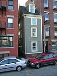
Skinny House (Boston) narrow house in Boston, Massachusetts

The Skinny House at 44 Hull Street in the North End of Boston, Massachusetts, USA, is an extremely narrow four-story house reported by the Boston Globe as having the "uncontested distinction of being the narrowest house in Boston." According to the executive director of the Boston Landmarks Commission, "In a city where there are many narrow lots, this far exceeds the norm. ... As far as we know, it is the narrowest house in Boston." It was originally built as a spite house.

Charles River Dam lock and dam on the Charles River in Boston, Massachusetts

The Charles River Dam is a flood control structure on the Charles River in Boston, Massachusetts, located just downstream of the Leonard P. Zakim Bunker Hill Memorial Bridge, near Lovejoy Wharf, on the former location of the Warren Bridge.
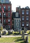
Boston Harborwalk

Boston Harborwalk is a public walkway that follows the edge of piers, wharves, beaches, and shoreline around Boston Harbor. When fully completed it will extend a distance of 47 miles (76 km) from East Boston to the Neponset River.

Benjamin Edes American journalist

Benjamin Edes was a journalist and political agitator. He is best known, along with John Gill, as the publisher of the Boston Gazette, a newspaper which sparked and financed the Boston Tea Party and was influential during the American Revolutionary War.

Paul Revere Park

Paul Revere Park is a 5-acre (2.0 ha) park located on the Charles River in Charlestown, Massachusetts. The park was the first park to open along the "Lost Half Mile" of the Charles River as mitigation for the taking of planned parkland for the construction of the Big Dig. The park runs along the Charles River between the Freedom Trail on North Washington Street and the Leonard P. Zakim Bunker Hill Memorial Bridge. The park features a large oval-shaped lawn, an informal performance area, and a playground.

References

  1. "Copp's Hill Burying Ground". Boston.gov. City of Boston. Retrieved 7 January 2019.