Nueces County is a county in the U.S. state of Texas. As of the 2010 census, the population was 340,223. The county seat is Corpus Christi. The county was formed in 1846 from portions of San Patricio County and organized the following year. It is named for the Nueces River, which flows through the county.
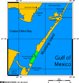
Mustang Island is a barrier island on the Gulf Coast of Texas in the United States. The island is 18 miles (29 km) long, stretching from Corpus Christi to Port Aransas. The island is oriented generally northeast-southwest, with the Gulf of Mexico on the east and south, and Corpus Christi Bay on the north and west. The island's southern end connects by roadway to Padre Island. At the northern end of the island is Port Aransas, beyond which is San José Island. The Aransas Channel, also known as the "Aransas Pass," which separates Mustang Island from San José Island, is protected by jetties extending into the Gulf from each island.
Corpus Christi Memorial Hospital is a hospital in Corpus Christi, Texas. It is the second largest in the Christus Spohn hospital system with 397 beds and 30 resident physicians, and is the lead emergency facility in the region and is a level two trauma facility. It operates under Texas A&M University's Health Science Center College of Medicine.

The Roman Catholic Diocese of Corpus Christi is a Roman Catholic diocese in Texas. It was founded on March 23, 1912.

Mirador de la Flor also known as Selena's seawall is a monument in Corpus Christi, Texas that was unveiled in 1997 to honor Selena, the Tejano singer who was murdered by her assistant and head of her fan club Yolanda Saldívar, two years earlier at the age of 23. People from around the world visit the site, which is located only a few miles north of Seaside Memorial Park where Selena is buried. It is located at the corner of Peoples Street T-Head and Shoreline Boulevard and consists of a 5'8" life-sized bronze statue of Selena wearing a leather jacket with microphone in hand, sculpted by H.W. "Buddy" Tatum, a Corpus Christi artist. She is leaning against a concrete pillar looking towards the Corpus Christi Bay. About 30,000 people visit this monument every year.

The Hans and Pat Suter Wildlife Refuge is a wildlife refuge in Corpus Christi, Texas. The Refuge is located on the western shore of Oso Bay, on Ennis Joslin Road, near the Pharaoh Valley subdivision.

RealmsCon is an annual three-day multi-genre convention held during September/October at the Omni Corpus Christi Hotel in Corpus Christi, Texas. The convention was created in 2005 by Daniel Velasquez.
KSGR is an FM religious radio station that serves the Corpus Christi, Texas area. It is under ownership of Calvary Chapel of the Coastlands, Inc. "Solid Ground" is a reference to the Biblical Parable of the two builders.

Mary Carroll High School, often referred to as Carroll, is one of six high schools that are part of the Corpus Christi Independent School District.

KKPN, known as "Planet 102.3", is a Top 40 radio station serving the Corpus Christi Metropolitan Area in the state of Texas. The station's musical format includes a balance of hip hop, rock music, and pop music in rotation. Its studios are located along South Padre Island Drive in Corpus Christi, and the transmitter is in Ingleside, Texas.
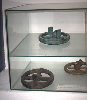
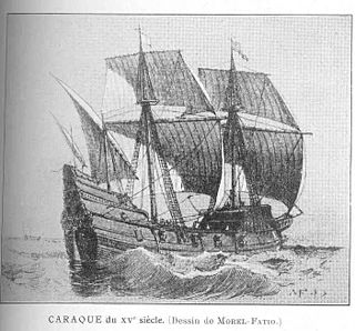
The mariner's astrolabe, also called sea astrolabe, was an inclinometer used to determine the latitude of a ship at sea by measuring the sun's noon altitude (declination) or the meridian altitude of a star of known declination. Not an astrolabe proper, the mariner's astrolabe was rather a graduated circle with an alidade used to measure vertical angles. They were designed to allow for their use on boats in rough water and/or in heavy winds, which astrolabes are ill-equipped to handle. In the sixteenth century, the instrument was also called a ring.
KNDA is an urban contemporary radio station serving the Corpus Christi, Texas area. KNDA broadcasts at 102.9 MHz with an ERP of 50,000 watts, is licensed to serve the community of Alice, Texas, and is owned by Guerra Communications. Its studios are in Corpus Christi and its transmitter is southwest of Robstown, Texas.
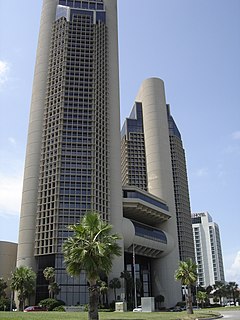
One Shoreline Plaza in Corpus Christi, Texas overlooks Corpus Christi Bay and consists of 2 skyscrapers, north and south, south being the tallest, and the tallest building in South Texas south of San Antonio. It is the most prominent figure in the skyline of the city.
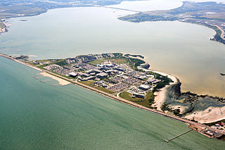
Oso Bay is a bay bordered by Corpus Christi, Texas. The bay is fed freshwater by Oso Creek and saltwater from Corpus Christi Bay. The Hans and Pat Suter Wildlife Refuge is located on the bay's western shore near the Pharaoh Valley subdivision, Naval Air Station Corpus Christi is located on its eastern shore in Flour Bluff, newly created Skimmer Key is located between the Oso Bay Bridge and the Naval Air Station, and Texas A&M University - Corpus Christi on Ward Island is located on the northern shore of Oso Bay.

KKTX is a radio station serving the Corpus Christi, Texas area with a News/Talk format. It broadcasts on AM frequency 1360 kHz and is under ownership of iHeartMedia, Inc.. The station's studios and offices are located on Old Brownsville Road in Corpus Christi (near the airport, and its transmitter tower is located in the city's west side along Leopard Street.
Richard King High School, or King as it is often referred to, is one of five secondary schools that are part of the Corpus Christi Independent School District in Corpus Christi, Texas (USA). It is one of the largest high schools within the Corpus Christi area and is classified as a 5A school by the UIL. In 2013, the school was rated "Met Standard" by the Texas Education Agency.
Foy H. Moody High School is a public high school located in the city of Corpus Christi, Texas and classified as a 5A school by the UIL. It is a part of the Corpus Christi Independent School District located in southeast Nueces County. In 2015, the school was rated "Met Standard" by the Texas Education Agency.
Corpus Christi Army Depot (CCAD) is a United States Department of Defense (DoD) Center of Industrial and Technical Excellence (CITE) for rotary wing aircraft. It has been a tenant of Naval Air Station Corpus Christi since 1961.
The following is a timeline of the history of the city of Corpus Christi, Texas, USA.