Council Bluffs Municipal Airport

Last updated
Council Bluffs Municipal Airport
Summary
Airport type Public
Owner Council Bluffs Airport Authority
Serves Council Bluffs, Iowa
Elevation  AMSL 1,245 ft / 379 m
Coordinates 41°15′36″N095°45′31″W / 41.26000°N 95.75861°W / 41.26000; -95.75861 Coordinates: 41°15′36″N095°45′31″W / 41.26000°N 95.75861°W / 41.26000; -95.75861
Website www.cbairport.com
Map
USA Iowa location map.svg
Airplane silhouette.svg
CBF
Location of airport in Iowa/United States
Usa edcp relief location map.png
Airplane silhouette.svg
CBF
CBF (the US)
Runways
Direction LengthSurface
ftm
18/365,5001,676Concrete
14/323,6501,113Concrete
Statistics (2012)
Aircraft operations 40,050
Based aircraft 83

Council Bluffs Municipal Airport( IATA : CBF, ICAO : KCBF, FAA LID : CBF) is a public use airport located four  nautical miles (5  mi, 7  km) east of the central business district of Council Bluffs, a city in Pottawattamie County, Iowa, United States. It is owned by Council Bluffs Airport Authority. [1] This airport is included in the National Plan of Integrated Airport Systems for 2011–2015, which categorized it as a general aviation facility. [2]

An IATA airport code, also known as an IATA location identifier, IATA station code or simply a location identifier, is a three-letter code designating many airports around the world, defined by the International Air Transport Association (IATA). The characters prominently displayed on baggage tags attached at airport check-in desks are an example of a way these codes are used.

ICAO airport code four-letter code designating many airports around the world

The ICAOairport code or location indicator is a four-letter code designating aerodromes around the world. These codes, as defined by the International Civil Aviation Organization and published in ICAO Document 7910: Location Indicators, are used by air traffic control and airline operations such as flight planning.

Federal Aviation Administration United States Government agency dedicated to civil aviation matters

The Federal Aviation Administration (FAA) is a governmental body of the United States with powers to regulate all aspects of civil aviation in that nation as well as over its surrounding international waters. Its powers include the construction and operation of airports, air traffic management, the certification of personnel and aircraft, and the protection of U.S. assets during the launch or re-entry of commercial space vehicles. Powers over neighboring international waters were delegated to the FAA by authority of the International Civil Aviation Organization.

Contents

Flight school and air charter company Advanced Air Inc. operates out of this airport. The airport is also the site of Iowa Western Community College's Aviation Maintenance Technology program, and their Professional Pilot training program.

Iowa Western Community College is a community college in Council Bluffs, Iowa. The college was founded in 1967, and offers 84 programs in both vocational and technical areas as well as in liberal arts. It is also home to a respected flight school for various aircraft related professions.

The airport has many instrument approaches, including an ILS to Runway 36, and a VOR-A approach that are both used regularly for training.

Facilities and aircraft

Council Bluffs Municipal Airport covers an area of 656 acres (265 ha) at an elevation of 1,245 feet (379 m) above mean sea level. It has two runways with concrete surfaces: 18/36 is 5,500 by 100 feet (1,676 x 30 m) and 14/32 is 3,650 by 60 feet (1,113 x 18 m). [1]

Acre unit of area

The acre is a unit of land area used in the imperial and US customary systems. It is traditionally defined as the area of one chain by one furlong, which is exactly equal to 10 square chains, ​1640 of a square mile, or 43,560 square feet, and approximately 4,047 m2, or about 40% of a hectare. Based upon the International yard and pound agreement of 1959, an acre may be declared as exactly 4,046.8564224 square metres. The acre is a statute measure in the United States and was formerly one in the United Kingdom and almost all countries of the former British Empire, although informal use continues.

Hectare metric unit of area

The hectare is an SI accepted metric system unit of area equal to a square with 100-metre sides, or 10,000 m2, and is primarily used in the measurement of land. There are 100 hectares in one square kilometre. An acre is about 0.405 hectare and one hectare contains about 2.47 acres.

Elevation Height of a geographic location above a fixed reference point

The elevation of a geographic location is its height above or below a fixed reference point, most commonly a reference geoid, a mathematical model of the Earth's sea level as an equipotential gravitational surface . The term elevation is mainly used when referring to points on the Earth's surface, while altitude or geopotential height is used for points above the surface, such as an aircraft in flight or a spacecraft in orbit, and depth is used for points below the surface.

For the 12-month period ending March 22, 2012, the airport had 40,050 aircraft operations, an average of 109 per day: 96% general aviation, 4% air taxi, and <1% military. At that time there were 83 aircraft based at this airport: 63% single-engine, 14.5% multi-engine, 8% jet, and 14.5% helicopter. [1]

General aviation civil use of aircraft excluding commercial transportation

General Aviation (GA) represents the 'private transport' and recreational flying component of aviation.

Air taxi on-demand commercial air transportation, particularly of smaller quantities of passenger or cargo by aeroplane or helicopter

An air taxi is a small commercial aircraft which makes short flights on demand.

Military aviation use of aircraft by armed forces in combat or other military capacity

Military aviation is the use of military aircraft and other flying machines for the purposes of conducting or enabling aerial warfare, including national airlift capacity to provide logistical supply to forces stationed in a theater or along a front. Airpower includes the national means of conducting such warfare, including the intersection of transport and war craft. Military aircraft include bombers, fighters, transports, trainer aircraft, and reconnaissance aircraft.

Related Research Articles

Iowa City Municipal Airport

Iowa City Municipal Airport, is two miles southwest of Iowa City, in Johnson County, Iowa. It is the oldest civil airport west of the Mississippi River still in its original location.

Baker City Municipal Airport

Baker City Municipal Airport is three miles north of Baker City, in Baker County, Oregon. The National Plan of Integrated Airport Systems for 2011–2015 categorized it as a general aviation facility.

Keokuk Municipal Airport

Keokuk Municipal Airport is five miles northwest of Keokuk, in Lee County, Iowa. The National Plan of Integrated Airport Systems for 2017–2021 categorized it as a general aviation facility.

Atlantic Municipal Airport

Atlantic Municipal Airport, is a city-owned public-use airport located two miles (3 km) west of the central business district of Atlantic, a city in Cass County, Iowa, United States. The airport has a runway opened in 2006 capable of handling light business jets.

Marianna Municipal Airport airport

Marianna Municipal Airport is five miles northeast of Marianna, in Jackson County, Florida. The FAA's National Plan of Integrated Airport Systems for 2009–2013 categorized it as a general aviation airport. It was formerly Graham Air Base.

Stuttgart Municipal Airport

Stuttgart Municipal Airport is in Prairie County, Arkansas. It is eight miles north of Stuttgart, which owns the airport and is the county seat of Arkansas County. The FAA's National Plan of Integrated Airport Systems for 2009–2013 categorized it as a general aviation facility.

Marshfield Municipal Airport (Wisconsin)

Marshfield Municipal Airport is a city owned public use airport located one nautical mile (2 km) south of the central business district of Marshfield, a city in Wood County, Wisconsin, United States. It is included in the Federal Aviation Administration (FAA) National Plan of Integrated Airport Systems for 2019–2023, in which it is categorized as a local general aviation facility.

Clinton Municipal Airport (Iowa)

Clinton Municipal Airport is seven miles southwest of Clinton, in Clinton County, Iowa. The FAA's National Plan of Integrated Airport Systems (2017-2021) categorizes it as a general aviation airport.

Independence Municipal Airport (Iowa)

Independence Municipal Airport is a city-owned public-use airport located three nautical miles (6 km) southwest of the central business district of Independence, a city in Buchanan County, Iowa, United States. As per the FAA's National Plan of Integrated Airport Systems for 2009-2013, it is classified as a general aviation airport.

Centerville Municipal Airport (Iowa)

Centerville Municipal Airport is a city-owned public-use airport located three nautical miles (6 km) southwest of the central business district of Centerville, a city in Appanoose County, Iowa, United States. According to the FAA's National Plan of Integrated Airport Systems for 2009–2013, it is categorized as a general aviation airport.

Red Oak Municipal Airport

Red Oak Municipal Airport is a city-owned public-use airport located two nautical miles (3.7 km) west of the central business district of Red Oak, a city in Montgomery County, Iowa, United States. According to the FAA's National Plan of Integrated Airport Systems for 2009–2013, it is categorized as a general aviation facility.

Mount Pleasant Municipal Airport (Iowa)

Mount Pleasant Municipal Airport is a city-owned public-use airport located three nautical miles southeast of the central business district of Mount Pleasant, a city in Henry County, Iowa, United States. According to the FAA's National Plan of Integrated Airport Systems for 2009–2013, it is categorized as a general aviation facility.

Orange City Municipal Airport

Orange City Municipal Airport is a city-owned public-use airport located one nautical mile (1.85 km) south of the central business district of Orange City, a city in Sioux County, Iowa, United States. This airport is included in the FAA's National Plan of Integrated Airport Systems for 2009–2013, which categorized it as a general aviation facility.

Perry Municipal Airport (Iowa)

Perry Municipal Airport is a city-owned public-use airport located three nautical miles west of the central business district of Perry, a city in Dallas County, Iowa, United States. This airport is included in the FAA's National Plan of Integrated Airport Systems for 2015–2019, which categorized it as a general aviation facility.

Osceola Municipal Airport (Iowa)

Osceola Municipal Airport is a city-owned public-use airport located four nautical miles northeast of the central business district of Osceola, a city in Clarke County, Iowa, United States. It is included in the National Plan of Integrated Airport Systems for 2011–2015, which categorized it as a general aviation facility.

Winterset Municipal Airport

Winterset Municipal Airport is a public use airport located two nautical miles (4 km) north of the central business district of Winterset, a city in Madison County, Iowa, United States. Formerly known as Winterset-Madison County Airport, it is owned by the Winterset Airport Authority. This airport is included in the National Plan of Integrated Airport Systems for 2011–2015, which categorized it as a general aviation facility.

Boone Municipal Airport

Boone Municipal Airport is a city-owned public-use airport located two nautical miles (4 km) southeast of the central business district of Boone, a city in Boone County, Iowa, United States. It is included in the National Plan of Integrated Airport Systems for 2011–2015, which categorized it as a general aviation facility.

Creston Municipal Airport

Creston Municipal Airport is a city-owned public-use airport located three nautical miles (6 km) south of the central business district of Creston, a city in Union County, Iowa, United States. It is included in the National Plan of Integrated Airport Systems for 2011–2015, which categorized it as a general aviation facility.

Denison Municipal Airport

Denison Municipal Airport is a city-owned, public-use airport located two nautical miles (4 km) southwest of the central business district of Denison, a city in Crawford County, Iowa, United States. It is included in the National Plan of Integrated Airport Systems for 2011–2015, which categorized it as a general aviation facility.

Webster City Municipal Airport

Webster City Municipal Airport is a city-owned public-use airport located three nautical miles (6 km) southwest of the central business district of Webster City, in Hamilton County, Iowa, United States. It is included in the National Plan of Integrated Airport Systems for 2015–2019, which categorized it as a general aviation facility.

References

  1. 1 2 3 4 FAA Airport Master Record for CBF ( Form 5010 PDF ). Federal Aviation Administration. Effective May 31, 2012.
  2. "2011–2015 NPIAS Report, Appendix A" (PDF). National Plan of Integrated Airport Systems. Federal Aviation Administration. October 4, 2010. Archived from the original (PDF, 2.03 MB) on 2012-09-27.
Fixed-base operator company offering air-side aviation services at an airport

A fixed-base operator (FBO) is an organization granted the right by an airport to operate at the airport and provide aeronautical services such as fueling, hangaring, tie-down and parking, aircraft rental, aircraft maintenance, flight instruction, and similar services. In common practice, an FBO is the primary provider of support services to general aviation operators at a public-use airport and is located either on airport leasehold property or, in rare cases, adjacent to airport leasehold property as a "through the fence operation". In many smaller airports serving general aviation in remote or modest communities, the town itself may provide fuel services and operate a basic FBO facility. Most FBOs doing business at airports of high to moderate traffic volume are non-governmental organizations, i.e., either privately or publicly held companies.

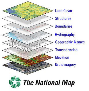
The National Map

The National Map is a collaborative effort of the United States Geological Survey (USGS) and other federal, state, and local agencies to improve and deliver topographic information for the United States. The purpose of the effort is to provide "...a seamless, continuously maintained set of public domain geographic base information that will serve as a foundation for integrating, sharing, and using other data easily and consistently".