
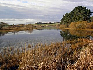
Craik Forest is a forest near Hawick in the Scottish Borders area of Scotland, and managed by the Forestry Commission. It is adjoined to the south-west by Eskdalemuir Forest.
Craik Forest is a forest near Hawick in the Scottish Borders area of Scotland, and managed by the Forestry Commission. It is adjoined to the south-west by Eskdalemuir Forest.
55°22′40″N3°02′10″W / 55.37774°N 3.036°W
| | This Scottish Borders location article is a stub. You can help Wikipedia by expanding it. |
Philiphaugh is a village by the Yarrow Water, on the outskirts of Selkirk, in the Scottish Borders.
Whitsome is a small rural village in the Scottish Borders area of Scotland, on the B6437, near Duns, Fogo, Ladykirk, Leitholm and Swinton.

Southdean is a hamlet in the Scottish Borders area of Scotland, on the A6088, by the Jed Water and in the Wauchope Forest area. Other settlements nearby include Abbotrule, Bedrule, Bonchester Bridge, Denholm, Hallrule, Hobkirk and the Swinnie Forest.

Kirkton is a village in the Scottish Borders area of Scotland, off the A6088, near Hawick. Grid Ref. NT5413.

Kailzie Gardens is a walled garden near Kirkburn in the Scottish Borders area of Scotland, in the Tweed valley, 2.5 miles (4 km) east of Peebles, off the B7062.
Dryhope is a village in the Scottish Borders area of Scotland, by St. Mary's Loch, on the A708. Known for its rolling green hills and ample walking paths. Also home of St Mary's Loch, the largest natural loch in the Scottish Borders.

Wauchope is a hamlet in the Scottish Borders council area of Scotland, near Southdean.

Wauchope Forest is a forest on the Rule Water, in the Scottish Borders area of Scotland, south of Hawick, and including the A6088, the A68 and the B6357, as well as Newcastleton, Bonchester Bridge, Hobkirk, Southdean, Hyndlee, Carter Bar, Abbotrule, Chesters, Scottish Borders.

Burnfoot is a hamlet in the Scottish Borders area of Scotland, close to Roberton, by the Borthwick Water. The nearest town is Hawick to the east, and other places nearby include the Alemoor Loch, Branxholme, Broadhaugh, the Craik Forest. The meaning of Burnfoot is "Place at the foot of the burn".

Craik is a hamlet in Craik Forest, by the Airhouse Burn in the Scottish Borders area of Scotland, close to Roberton, Scottish Borders.
The Bothwell Water is a river in the Scottish Borders area of Scotland. It rises in the Lammermuir Hills near Caldercleugh and continues past the Upper Monynut Forest, Crichness, Bothwell Hill, and the village of Bothwell, when it joins the Whiteadder Water.

The Cardrona Forest is a forest in the Scottish Borders area of Scotland, on in Tweed Valley, near Peebles. A nearby forest is Glentress Forest. The forest contains 2,000 years of Scottish history, and is home to ruins. It is popular among cyclists and hikers, for it has a network of trails, many of which have names.

Horsburgh Castle, also known as Horsbrugh Castle or Horsbrugh Tower, is a ruined tower house castle by the River Tweed, on the A72 road from Peebles to Galashiels, near Glentress in the Scottish Borders area of Scotland. The ruins date from the 16th century and was built by the Horsburghs.

The Borthwick Water(Border Scots: Borthwick Witter) is a river in the Scottish Borders area of Scotland, and a tributary of the River Teviot.

Yarrowford is a village on the A708, in the Scottish Borders area of Scotland, 4 miles north-west of Selkirk, in the Ettrick Forest.
Lindean is a village north of Selkirk and the Ettrick Water, in the Scottish Borders area of Scotland.

Peniel Heugh is a hill near Ancrum and Nisbet in the Scottish Borders area of Scotland. On it stands the Waterloo Monument.
The Hermitage Water is a river in Liddesdale, in the Scottish Borders area of Scotland. Among its many feeder burns are Braidley Burn, Dinley Burn, Gorrenberry Burn and Twislehope Burn. The Water flows through the hamlets of Dinley and Gorrenberry, and through the village of Hermitage, and past Hermitage Castle. It continues past Toftholm where it meets the B6399, and passes Newlands, Longhaugh, Leahaugh and Redheugh. At Sandholm it joins the Liddel Water and the dismantled railway.

Cranshaws is a village on the B6355 road, near Duns, in the Scottish Borders area of Scotland, in the former Berwickshire.

Eskdalemuir Forest is a forest north of Eskdalemuir, Dumfries and Galloway, in southern Scotland. It was created as a private enterprise by the Economic Forestry Group during the 1970s. Eskdalemuir Forest is adjoined by Craik Forest to the north-east and Castle O'er Forest to the south. Eskdalemuir is one of a number of small settlements lying along the White Esk valley which bisects Eskdalemuir forest.