Grand Isle is a town in Jefferson Parish, Louisiana, United States, located on a barrier island of the same name in the Gulf of Mexico. The island is at the mouth of Barataria Bay where it meets the gulf. As of the 2010 census, the town's resident population was 1,296, down from 1,541 in 2000; during summers, the population, including tourists and seasonal residents, sometimes increases to over 20,000. Grand Isle is statistically part of the New Orleans−Metairie−Kenner Metropolitan Statistical Area, though it is not connected to New Orleans' continuous urbanized area.

The Bald Knob National Wildlife Refuge is a 15,022 acres (60.79 km2) (2014) wildlife refuge located in White County, Arkansas about two miles south of the town of Bald Knob. The refuge is managed by the United States Fish and Wildlife Service. The refuge features large numbers of migratory waterfowl and bald eagles during the winter months.

The Bombay Hook National Wildlife Refuge is a 15,978 acres (64.66 km2) National Wildlife Refuge located along the eastern coast of Kent County, Delaware, United States, on Delaware Bay. It was established on March 16, 1937 as a refuge and breeding ground for migratory and wintering waterfowl along the Atlantic Flyway. The Refuge was purchased from local land owners with federal duck stamp funds.

Don Edwards San Francisco Bay National Wildlife Refuge (DESFBNWR) is a United States National Wildlife Refuge located in the southern part of San Francisco Bay, California. The Refuge headquarters and visitor center is located in the Baylands district of Fremont, next to Coyote Hills Regional Park, in Alameda County. The visitor center is on Marshlands Rd, off Thornton Ave.

The Erie National Wildlife Refuge is an 8,777-acre (3,552 ha) National Wildlife Refuge located in Crawford County, Pennsylvania. Named after the Erie tribe, it was established to provide waterfowl and other migratory birds with nesting, feeding, brooding, and resting habitat.

Valemount is a village municipality of 1,018 people in east central British Columbia, Canada, 320 kilometres (200 mi) from Kamloops, British Columbia. It is between the Rocky, Monashee, and Cariboo Mountains. It is the nearest community to the west of Jasper National Park, and is also the nearest community to Mount Robson Provincial Park, which features Mount Robson, the tallest mountain in the Canadian Rockies. Outdoor recreation is popular in summer and winter—hiking, skiing, snowmobiling, cross country skiing, mountain biking and horseback riding are common activities. Valemount is one of 14 designated Resort Municipalities in British Columbia.

The Atlantic Flyway is a major north-south flyway for migratory birds in North America. The route generally starts in Greenland, then follows the Atlantic coast of Canada, then south down the Atlantic Coast south to the tropical areas of South America and the Caribbean. Every year, migratory birds travel up and down this route following food sources, heading to breeding grounds, or traveling to overwintering sites.
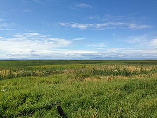
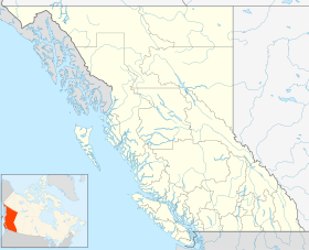
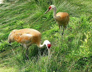
The Alaksen National Wildlife Area is located on Westham Island in the city of Delta, British Columbia. It is an important stopover point for many species of birds migrating along the Pacific Flyway.
The Creston Valley Wildlife Management Area is a Canadian river delta wetland and Wildlife Management Area near Creston in south-central British Columbia, on the floodplain of the Kootenay River at the south end of Kootenay Lake. Predominantly marshland, it was classified as a wetland of international importance on February 21, 1994, and is also a globally significant Important Bird Area. It is one of the "few significant agricultural areas of the province", and is in the Montane Cordillera. It stretches north along Kootenay Lake for approximately 20 km, and south to the United States border. It is both the only breeding site of the Forster's tern and the only site with leopard frogs in the province, as well as one of the few Canadian habitats for the Coeur D'Alene salamander. Creston Valley provides staging and nesting areas for migratory birds on the Pacific Flyway.

The Central Asian Flyway (CAF), Central Asian-Indian Flyway, or Central Asian-South Asian Flyway is a flyway covering a large continental area of Eurasia between the Arctic Ocean and the Indian Ocean and the associated island chains. The CAF comprises several important migration routes of waterbirds, most of which extend from the northernmost breeding grounds in Siberia to the southernmost non-breeding wintering grounds in West Asia, India, the Maldives and the British Indian Ocean Territory.
George C. Reifel Migratory Bird Sanctuary is a protected area in Delta, British Columbia, Canada, and is part of the Fraser River estuary, designated a site of Hemispheric Importance by the Western Hemisphere Shorebird Reserve Network.

The Sonny Bono Salton Sea National Wildlife Refuge is located 40 miles (64 km) north of the Mexican border at the southern end of the Salton Sea in California's Imperial Valley. Situated along the Pacific Flyway, the Refuge is the only one of its kind, located 227 feet (69 m) below sea level. Because of its southern latitude, elevation and location in the Colorado Desert, the Refuge experiences some of the highest temperatures in the nation. Daily temperatures from May to October generally exceed 100 °F with temperatures of 116°–120 °F recorded yearly.

Glenn Martin National Wildlife Refuge includes the northern half of Smith Island, which lies 11 miles (18 km) west of Crisfield, Maryland, and Watts Island, which is located between the eastern shore of Virginia and Tangier Island. Both islands are situated in the lower Chesapeake Bay.

Located in Coos County, New Hampshire and Oxford County, Maine, Umbagog National Wildlife Refuge is a northern treasure in the National Wildlife Refuge System. The diversity of exceptional habitats provides excellent breeding and foraging areas for migratory birds, endangered species, resident wildlife, and rare plants. The refuge protects over 25,650 acres (103.8 km2) of wetland and forested upland habitat along Umbagog Lake. About 70% of its area is in New Hampshire and 30% in Maine.

Hagerman National Wildlife Refuge (HNWR), a haven for migratory birds and other wildlife, lies in northwestern Grayson County, Texas, on the Big Mineral Arm of Lake Texoma, on the Red River between Oklahoma and Texas. This National Wildlife Refuge is made up of water, marsh, and upland habitat. Visitors can hike, observe wildlife, hunt, and fish throughout the year.
The San Diego National Wildlife Refuge Complex is a series of wildlife refuges established by the United States National Wildlife Service beginning in 1972. The complex incorporates five refuges in San Diego County and Orange County in California.

The Maplewood Flats Conservation Area is a 126 hectare conservation area located in North Vancouver, British Columbia, Canada. The area is composed of a 96 hectare intertidal zone of mudflats and salt marsh, and a 30 hectare upland area. It is preserved by Port Metro Vancouver as one of their ecological land initiatives. The land is located approximately 2 km east of the Second Narrows Bridge along Burrard Inlet in North Vancouver.

Todagin Wildlife Management Area is a wildlife management area located southeast of Iskut in northwestern British Columbia. It was established by the British Columbia Ministry of Forests, Lands, Natural Resource Operations and Rural Development (FLNRORD) on 19 March 2001 to conserve and manage critical habitat for stone sheep. It is the largest wildlife management area in British Columbia at 122,787 ha.

Boundary Bay Wildlife Management Area is a wildlife management area encompassing the entire Canadian portion of Boundary Bay in the Lower Mainland of British Columbia. It was established by the British Columbia Ministry of Forests, Lands, Natural Resource Operations and Rural Development (FLNRORD) on 21 June 1995 to conserve critical habitat for migratory bird species and resident fish and marine mammal species. It is part of the larger Fraser River Delta Ramsar Site.