
Wilkes-Barre is a city in the Commonwealth of Pennsylvania and the county seat of Luzerne County. It is one of the principal cities in the Scranton–Wilkes-Barre–Hazleton, PA Metropolitan Statistical Area. Located at the center of the Wyoming Valley, it is second in size to the nearby city of Scranton. The Scranton–Wilkes-Barre–Hazleton, PA Metropolitan Statistical Area had a population of 563,631 as of the 2010 Census, making it the fourth-largest metro/statistical area in the state of Pennsylvania. Wilkes-Barre and the surrounding Wyoming Valley are framed by the Pocono Mountains to the east, the Endless Mountains to the north and west, and the Lehigh Valley to the south. The Susquehanna River flows through the center of the valley and defines the northwestern border of the city.

Hanover Township is a township in Luzerne County, Pennsylvania, United States. As of the 2010 census, the population was 11,076, making it the most populous township in the county.
Interstate 676 (I-676) is an Interstate Highway that serves as a major thoroughfare through Center City Philadelphia, where it is known as the Vine Street Expressway, and Camden, New Jersey, where it is known as the northern segment of the North–South Freeway, as well as the Martin Luther King Jr. Memorial Highway in honor of civil rights leader Martin Luther King Jr. Its western terminus is at I-76 in Philadelphia near the Philadelphia Museum of Art and Fairmount Park. From there it heads east and is then routed on surface streets near Franklin Square and Independence Mall, home of the Liberty Bell, before crossing the Benjamin Franklin Bridge. On the New Jersey side of the bridge, the highway heads south to its southern terminus at I-76 in Gloucester City near the Walt Whitman Bridge. Between the western terminus and downtown Camden, I-676 is concurrent with U.S. Route 30.
Interstate 76 (I-76) is an Interstate Highway in the Eastern United States, running about 434 miles (700 km) from an interchange with I-71 west of Akron, Ohio, east to I-295 in Bellmawr, New Jersey.
The Schuylkill Expressway, locally known as "the Schuylkill", is a two to eight lane freeway through southwestern Montgomery County and the city of Philadelphia, and the easternmost segment of Interstate 76 in the U.S. state of Pennsylvania. It extends from the Valley Forge exit of the Pennsylvania Turnpike in King of Prussia, paralleling its namesake Schuylkill River for most of the route, to the Walt Whitman Bridge in South Philadelphia. It serves as the primary corridor into Philadelphia from points west. Maintenance and planning are administered through Pennsylvania Department of Transportation (PennDOT) District 6. Constructed over a period of ten years from 1949 to 1959, a large portion of the expressway predates the 1956 introduction of Interstate Highway System; many of these portions were not built to contemporary standards. The rugged terrain, limited riverfront space covered by the route and narrow spans of bridges passing over the highway have largely stymied later attempts to upgrade or widen the highway. With the road being highly over capacity, it has become notorious for its chronic congestion. An average of 163,000 vehicles use the road daily in Philadelphia County, and an average of 109,000 use the highway in Montgomery County, making it the busiest road in commonwealth of Pennsylvania. Its narrow lane and left shoulder configuration, left lane entrances and exits, common construction activity and generally congested conditions have led to many accidents, critical injuries and fatalities, leading to the highway's humorous nickname of the "Surekill Expressway" or in further embellishment, the "Surekill Distressway" or the “Surekill Crawlway".
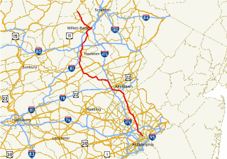
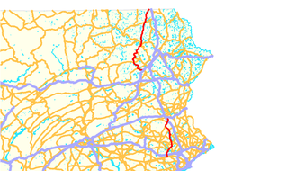
Pennsylvania Route 309 is a major highway which runs for 134 miles (216 km) through Pennsylvania in the United States. The route runs from the interchange between PA 611 and Cheltenham Avenue on the border of Philadelphia and Cheltenham Township north to an intersection with PA 29 in Bowman Creek, a village in Monroe Township, Wyoming County. It connects Philadelphia and its northern suburbs to Allentown, Hazleton, and Wilkes-Barre. A limited-access highway portion of PA 309 in the Wilkes-Barre area is known as the North Cross Valley Expressway. A limited-access highway portion of PA 309 in Montgomery County is known as the Fort Washington Expressway. PA 309 parallels the newer Interstates 476 and 81 for much of its length.

The Lackawanna & Wyoming Valley Railroad, more commonly known as the Laurel Line, was a Pennsylvania third rail electric interurban streetcar line which operated commuter train service from 1903 to 1952, and freight service until 1976. Its main line ran from Scranton to Wilkes-Barre.
U.S. Route 422 (US 422) is a 271-mile (436 km) long spur route of US 22 split into two segments in the U.S. states of Ohio and Pennsylvania. The western segment of US 422 begins in downtown Cleveland and ends at Ebensburg, Pennsylvania. The eastern segment, located entirely within Pennsylvania, begins in Hershey and ends at King of Prussia, PA, near Philadelphia. U.S. Route 422 Business is the offshoot road into each of 4 towns along the way.
Pennsylvania Route 29 is a 118-mile-long (190 km) north–south state highway that runs through most of eastern Pennsylvania. The route currently exists in two segments, a southern segment and a northern segment. The southern segment runs from U.S. Route 30 near Malvern north to Interstate 78 (I-78)/PA 309 near Allentown. The northern segment runs from I-81 in Ashley north to the New York-Pennsylvania border near Brookdale, where the route becomes New York State Route 7.

Pennsylvania Route 115 (PA 115) is a 35.7-mile-long (57.5 km) north–south state highway in eastern Pennsylvania. It stretches from U.S. Route 209 (US 209) in Brodheadsville, Monroe County to Interstate 81 (I-81) and PA 309 near Wilkes-Barre in Luzerne County. PA 115 passes through rural areas along its route, intersecting PA 903 in Tunkhannock Township, I-80 and PA 940 in Tobyhanna Township, and I-476 in Bear Creek Township. The road serves as a connector between The Poconos and the Wyoming Valley.
In the U.S. state of Pennsylvania, Interstate 70 (I-70) runs east–west across the southwest part of the state serving the southern fringe of the Pittsburgh metropolitan area. About half of the route is concurrent with I-76 on the Pennsylvania Turnpike. This is the oldest segment of I-70 in Pennsylvania, having been completed in 1940, and is only one of two segments of I-70 that are tolled, with the other being the Kansas Turnpike. I-70 is one of only a few Interstate Highways to have a traffic signal—in this case, with U.S. Route 30 in Breezewood, where it leaves the Pennsylvania Turnpike and heads toward Maryland.

Pennsylvania Route 378 (PA 378) is a north-to-south road in Lehigh and Northampton counties in the Lehigh Valley region of the U.S. state of Pennsylvania. The southern terminus is at PA 309 in Center Valley. Its northern terminus is at U.S. Route 22 (US 22) in Bethlehem. The route heads north from PA 309 as a two-lane undivided road through Upper Saucon Township and Lower Saucon Township before crossing South Mountain into the city of Bethlehem. Here, PA 378 follows city streets through Bethlehem's South Side, intersecting the northern terminus of PA 412. The route crosses the Lehigh River and becomes a four-lane freeway that continues north to US 22. PA 378 is the only highway from US 22 to Center City Bethlehem, and a quick route for visitors traveling to the Wind Creek Bethlehem casino resort on the city's South Side.

Pennsylvania Route 33 is a 27.7-mile-long (44.6 km) limited-access state highway in eastern Pennsylvania, United States. It runs from an interchange with Interstate 78 (I-78) just south of Easton to I-80 and PA 611 west of Stroudsburg. Until 2002, the route's southern terminus was at U.S. Route 22 (US 22), and the extension south of the US 22 interchange is known as the Gen. Anthony Clement McAuliffe 101st Airborne Memorial Highway. The route is commonly used as a hazmat bypass for the Pennsylvania Turnpike's Northeast Extension due to the restrictions in place on the Lehigh Tunnel. PA 33 provides a freeway connection between the Lehigh Valley and Pocono Mountains regions of Pennsylvania.
U.S. Route 1 is a major north–south U.S. Highway, extending from the Florida Keys in the south to the Canadian border in the north. In the U.S. state of Pennsylvania, US 1 runs for 81 miles (130 km) from the Maryland state line near Nottingham to the New Jersey state line near Trenton, through the southeastern portion of the state. The route runs southwest to northeast, and serves as a major arterial road for many of the suburbs in the Delaware Valley area. South of Philadelphia, the road mostly follows the alignment of the old Baltimore Pike. Within Philadelphia, it mostly follows Roosevelt Boulevard.

Pennsylvania Route 315 is an 8.2-mile-long (13.2 km) state highway located in Luzerne County, Pennsylvania. The southern terminus is at an interchange with the PA 309 freeway in Wilkes-Barre. The northern terminus is at the entrance of the Wilkes-Barre/Scranton International Airport in Pittston Township just past an interchange with Interstate 81 (I-81). PA 315 heads northeast from PA 309 as a multilane road through suburban development in the Wyoming Valley parallel to I-81. The route comes to an interchange with I-81 and I-476 before passing through Dupont along a one-way pair. Past here, PA 315 follows a divided highway to I-81 and the airport.
U.S. Route 202 runs through the southeastern part of the U.S. state of Pennsylvania, passing through the western and northern suburbs of Philadelphia. It follows a general southwest to northeast direction through the state, passing through or by West Chester, King of Prussia, Norristown, Montgomeryville, Doylestown, and New Hope.
U.S. Route 11 (US 11) roughly parallels Interstate 81 (I-81) in the U.S. state of Pennsylvania. It serves Harrisburg and Scranton. Between those two cities, US 11 follows the Susquehanna River, while I-81 follows a shorter route over the mountains.

West Nanticoke is a census-designated place (CDP) in Plymouth Township, Luzerne County, Pennsylvania, United States, across the Susquehanna River from the city of Nanticoke. The population of the CDP was 749 at the 2010 census.
Plains is a census-designated place (CDP) in Plains Township, Luzerne County, Pennsylvania, United States. The population of the CDP was 4,335 at the 2010 census, out of 9,961 in the entire township.
The Susquehanna Warrior Trail is a 12.21-mile (19.65 km) rail trail for bicyclists and pedestrians that runs along the west bank of the Susquehanna River in Luzerne County, Pennsylvania. The trail was created in 2005, and opened to the public in 2007. The Susquehanna Warrior Trail has not yet been dedicated. The trail is part of a plan to create a trail network covering all of Luzerne County.

