Wildlife
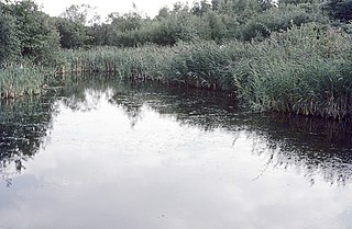
The location of the lakes, at the meeting point of three rivers makes it an ideal stop off point for migrating birds. Different birds use the reserve at different times of the year. In winter ducks such as mallard, Eurasian teal, wigeon, common goldeneye and northern shoveler are on the lake. In the early summer lapwing, oystercatcher, redshank and ringed plover breed in the reserve. Other birds that may be on the reserve include the short-eared owl, skylark, Canada goose and song thrush. Otters and water voles are amongst the mammals in the reserve.
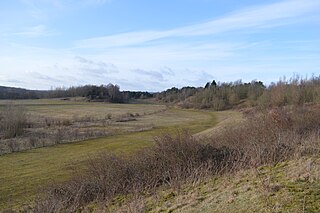
The Staffordshire Wildlife Trust have undertaken a number of projects to restore the site as a wildlife haven. These works include excavation of scrapes for wading birds and the creation of shallows and reedbeds on the two main lakes providing cover and nesting areas for breeding birds. Parts of the banks have been re-profiled and the resulting soil deposited into the lake to make more shallows and larger reedbeds. The process is known as 'river braiding' and creates a diversity of river features with still pools, shallow riffles and gravel islands which helps to restore natural river processes and better wildlife habitat.
The River Mease which joins the River Trent at the eastern extent of the site is a Site of Special Scientific Interest due to its populations of otters, native white-clawed crayfish and spined loach.

The Isle of Man is an island in the Irish Sea, between Great Britain and Ireland in Northwestern Europe, with a population of almost 85,000. It is a British Crown dependency. It has a small islet, the Calf of Man, to its south. It is located at 54°15′N4°30′W.

For the river in Greater Manchester, see River Tame, Greater Manchester.

The Staffordshire Wildlife Trust is a wildlife trust covering the county of Staffordshire, England.
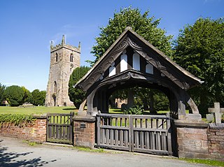
Alrewas is a village and civil parish in the Lichfield District of Staffordshire, England.
The National Memorial Arboretum is a British site of national remembrance at Alrewas, near Lichfield, Staffordshire. Its objective is to honour the fallen, recognise service and sacrifice, and foster pride in the British Armed Forces and civilian community.

The Cotswold Water Park is the United Kingdom's largest marl lake system, straddling the Wiltshire–Gloucestershire border, northwest of Cricklade and south of Cirencester. There are 180 lakes, spread over 42 square miles (110 km2).

Loynton Moss is a nature reserve of the Staffordshire Wildlife Trust, near the village of Woodseaves, in Staffordshire, England. It is adjacent to the Shropshire Union Canal, as it runs from nearby Norbury to High Offley.

Thatcham Reed Beds is a 67.4-hectare (167-acre) biological Site of Special Scientific Interest east of Newbury in Berkshire. It is part of the Kennet & Lambourn Floodplain Special Area of Conservation and an area of 14 hectares is a Local Nature Reserve. An area of 35 hectares is managed by the Berkshire, Buckinghamshire and Oxfordshire Wildlife Trust.

Brandon Marsh is a Site of Special Scientific Interest (SSSI) and nature reserve in Warwickshire, England. It is situated adjacent to the River Avon, near the village of Brandon, a few miles east of Coventry.
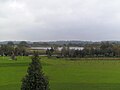
Whitemoor Haye is a mainly agricultural area in the floodplain of the River Tame, near Alrewas in Staffordshire, England.

Sevenoaks Gravel Pits is a 73.7-hectare (182-acre) biological Site of Special Scientific Interest on the northern outskirts of Sevenoaks in Kent. It is managed by Kent Wildlife Trust as the Sevenoaks Wildlife Reserve and Jeffery Harrison Visitor Centre.

The River Mease is a lowland clay river in the Midlands area of England. It flows through the counties of Leicestershire, Derbyshire and Staffordshire and forms the administrative border between these counties for parts of its length.
Middleton Lakes RSPB reserve is a 160 hectares nature reserve, formally opened on 19 May 2011, created and run by the Royal Society for the Protection of Birds at Middleton, Warwickshire, England, just south of Tamworth. The Northern part of the reserve lies in Staffordshire, yet the reserve is only a few minutes from the outskirts of Birmingham.

Attenborough Nature Reserve is a nature reserve at Attenborough, Nottinghamshire, England, located 4.3 mi (7 km) south west of Nottingham city centre. It is owned and managed by Nottinghamshire Wildlife Trust, supported by Broxtowe Borough Council, following the completion of purchase from Cemex UK in December 2020.

Amwell Quarry or Amwell Nature Reserve is a 37 hectare biological Site of Special Scientific Interest in Great Amwell in Hertfordshire. The planning authority is East Hertfordshire District Council. It is also part of the Lee Valley Ramsar Site and Special Protection Area, and is owned and managed by the Hertfordshire and Middlesex Wildlife Trust.
Waterford Heath is a 35.2 hectare Local Nature Reserve in Waterford in Hertfordshire, England. It is owned by Lafarge Tarmac and managed by the Herts and Middlesex Wildlife Trust together with East Hertfordshire District Council and Lafarge.
Fingringhoe Wick is a 48.6 hectare nature reserve in Fingringhoe in Essex. It is managed by the Essex Wildlife Trust, which runs a visitor centre on the site. It is part of the Colne Estuary Site of Special Scientific Interest, Ramsar site and Nature Conservation Review site.

Stanford Warren is a 16.6 hectare nature reserve south of Stanford-le-Hope in Essex. It is managed by the Essex Wildlife Trust.

River Mease SSSI is a 23.0 hectares biological Site of Special Scientific Interest. It is a stretch of the River Mease and its tributary Gilwiskaw Brook, running between Alrewas in Staffordshire and Packington in Leicestershire. It is also a Special Area of Conservation The river goes through private land, but it is crossed by roads and footpaths.

Stodmarsh SSSI is a 623.2-hectare (1,540-acre) biological Site of Special Scientific Interest near Stodmarsh, north-east of Canterbury in Kent. Parts of it are a Nature Conservation Review site, Grade I, a National Nature Reserve, a Ramsar internationally important wetland site, a Special Area of Conservation and a Special Protection Area under the European Union Directive on the Conservation of Wild Birds.