
The Coquimbo Region is one of Chile's 16 regions. It is bordered by Atacama to the north, Valparaíso to the south, Argentina to the east, and the Pacific Ocean to the west. It is approximately 400 kilometres (250 mi) north of the national capital, Santiago.

La Silla Observatory is an astronomical observatory in Chile with three telescopes built and operated by the European Southern Observatory (ESO). Several other telescopes are located at the site and are partly maintained by ESO. The observatory is one of the largest in the Southern Hemisphere and was the first in Chile to be used by ESO.

Paleo-Indians were the first peoples who entered and subsequently inhabited the Americas towards the end of the Late Pleistocene period. The prefix paleo- comes from the Ancient Greek adjective: παλαιός, romanized: palaiós, lit. 'old; ancient'. The term Paleo-Indians applies specifically to the lithic period in the Western Hemisphere and is distinct from the term Paleolithic.

The Diaguita people are a group of South American indigenous people native to the Chilean Norte Chico and the Argentine Northwest. Western or Chilean Diaguitas lived mainly in the Transverse Valleys that incise semi-arid mountains. Eastern or Argentine Diaguitas lived in the provinces of La Rioja and Catamarca and part of the provinces of Salta, San Juan and Tucumán. The term Diaguita was first applied to peoples and archaeological cultures by Ricardo E. Latcham in the early 20th century.

1000 Piazzia, provisional designation 1923 NZ, is a carbonaceous background asteroid from the outer region of the asteroid belt, approximately 48 kilometers in diameter. It was discovered on 12 August 1923, by German astronomer Karl Reinmuth at Heidelberg Observatory in southern Germany. The C-type asteroid has a rotation period of 9.5 hours. It was named after Italian Giuseppe Piazzi, who discovered 1 Ceres.
Sarmishsay is located in the Karatau Mountain Range in the Nurata District of Navoiy Region of Uzbekistan. The gorge contains archeological remains dating back as far as the Stone Age, including two petroglyph sites with a total of 10,000 ancient rock carvings. According to UNESCO, it is the largest and most important rock art monument in Uzbekistan.

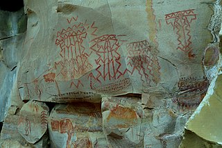
Combarbalá is the capital city of the commune of Combarbala. It is located in the Limarí Province, Region of Coquimbo, at an elevation of 900 m (2,952 ft). It is known for the tourist astronomic observatory Cruz del Sur; the petroglyphs of Rincon las Chilcas; its typical handcraft made of the unique combarbalita stone; the classical basketball match at the end February; the Virgen de la Piedra catholic-pagan festivity, among other tourist attractions.

The Pali-Aike National Park is a park located in the Magallanes Region of Patagonia in Chile. Pali-Aike is a Tehuelche name that means Desolate Place. Created in 1970, it covers an area of 5,030 hectares and includes part of the Pali-Aike Volcanic Field. The park draws its name from a prominent volcanic cone known as the Pali Aike Crater.

Salamanca is a Chilean city and commune in Choapa Province, Coquimbo Region. It is located 30 km (19 mi) east of Illapel, the province's administrative center, and 316 km (196 mi) north of Santiago, Chile. It is normally accessed from Los Vilos, which lies next to the Panamerican Highway, and connects the city to the rest of the country.

El Quisco is a Chilean city and commune in San Antonio Province, Valparaíso Region. Located in the country's central coast, it serves as a popular summer resort for the population of Santiago and forms part of the Coast of Poets, a cultural space named after four world-renowned Chilean poets: Pablo Neruda, Vicente Huidobro, Violeta Parra and Nicanor Parra. El Quisco is home to La Casa de Isla Negra, the former house of Chilean poet Pablo Neruda, which is now a museum and Neruda's burial site.
Barajas is an archaeological site located in the municipality of Pénjamo, Guanajuato, Mexico, which includes a large complex of approximately 15 archeological sites in good preservation state, built on a small volcanic massif in the Bajío.

Altavista, or Chalchihuites, is an archaeological site near the municipality of Chalchihuites in the Mexican state of Zacatecas, in the northwest of Mexico. It is believed that the site was a cultural oasis that was occupied more or less continuously from AD 100 to AD 1400.
Chiquihuitillos is an archaeological site situated in the municipality of Mina in Nuevo León, Mexico. The site is renowned for its petroglyphs and holds significance in the region's history.

Xihuacan is a Mesoamerican archeological site located on the Costa Grande of the Mexican state of Guerrero, near the small town of La Soledad de Maciel, and the larger towns of Zihuatanejo and Petatlán. While pieces had been found at the site earlier, including the King of La Chole stele and Mesoamerican ball court rings, formal excavations were only recently begun. The site had been occupied for over 3,000 years and by three cultures, with contact with other Mesoamerican cultures such as the Teotihuacan and Olmec. Explored areas include what may be the largest Mesoamerican ball court, a 1-hectare (2.5-acre) pyramidal base and a hill with petroglyphs and a probable sacrifice stone.

Las Choapas is a recently found archaeological site located within the municipality of Las Choapas, in the southeastern border of the Veracruz State, inside the San Miguel de Allende Ejido, bordering the municipalities of Huimanguillo, Tabasco and Ostuacán, in Chiapas.
Nununyi was a historic village of the Cherokee people in western North Carolina, located on the eastern side of the Oconaluftee River. Today it is within the boundaries of the present-day city of Cherokee in Swain County. It was classified by English traders and colonists as among the "Out Towns" of the Cherokee in this area east of the Appalachian Mountains.
The Andean preceramic refers to the early period of human occupation in the Andean area of South America that preceded the introduction of ceramics. This period is also called pre-ceramic or aceramic.

Ancon (archaeological site) is located in the north of the Bay of Ancon, in the Ancón District, on the central coast of Peru. It is one of the most important centers of the Peruvian archeology and features a vast necropolis of the pre-Hispanic era, with countless funerary sites. Permanent occupation in Ancon is documented throughout all periods of Andean history. The oldest evidence of human occupation dates back 10,000 years ago to the preceramic period.
The origin of the Mapuche has been a matter of research for over a century. The genetics of the Mapuche do not show overly clear affinities with any other known indigenous group in the Americas, and the same goes for linguistics, where the Mapuche language is considered a language isolate. Archaeological evidence shows Mapuche culture has existed in Chile at least since 600 to 500 BC. Mapuches are late arrivals in their southernmost and easternmost (Pampas) areas of settlement, yet Mapuche history in the north towards Atacama Desert may be older than historic settlement suggest. The Mapuche has received significant influence from Pre-Incan (Tiwanaku?), Incan and Spanish peoples, but deep origins of the Mapuche predates these contacts. Contact and conflict with the Spanish Empire are thought by scholars such as Tom Dillehay and José Bengoa to have had a profound impact on the shaping of the Mapuche ethnicity.