
Pasco County is a county located in the U.S. state of Florida. As of the 2010 census, the population was 464,697. Its county seat is Dade City, and its largest city is New Port Richey. The county is named for Samuel Pasco.
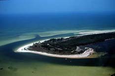
Anclote Key is an island off the Gulf Coast of the U.S. state of Florida, the largest island in the Anclote Keys, located at 28°11′16″N82°50′44″W near Tarpon Springs. Its name originates from the Spanish term for "anchor." The island is accessible only by boat and is split between Anclote Key Preserve State Park and Anclote National Wildlife Reserve. The island contains mangrove wetlands, coastal pine flatwoods, and beaches. A large number of shorebirds nest and breed on Anclote Key and the surrounding islands. Sand Key is located nearby. Most of the island is located within Pasco County, while its southernmost section is in Pinellas County. The island is home to the Anclote Keys Light.

The Withlacoochee River originates in central Florida's Green Swamp, east of Polk City. It flows west, then north, and then turns northwest and finally west again before it empties into the Gulf of Mexico near Yankeetown. The river is 141 miles (227 km) long and has a drainage basin of 1,170 square miles (3,000 km2). It is believed to have been named after the Withlacoochee River to the north.
The Southwest Florida Water Management District, is one of five regional agencies directed by Florida state law to protect and preserve water resources. Established in 1961 the agency operates and maintains several large properties and flood protection projects, sometimes with other agencies. The District's responsibilities have expanded to include managing water supply and protecting water quality and the natural systems — rivers, lakes, wetlands and associated uplands.

Aripeka is an unincorporated community and census-designated place (CDP) in the U.S. state of Florida, along coast of the Gulf of Mexico at the border dividing Pasco and Hernando counties. The ZIP Code for the community is 34679. As of the 2010 census the population was 308.
Eagle Point Park encompasses 15 acres (61,000 m2) of a 600-acre (2.4 km2) coastal nature preserve in Pasco County, Florida west of US 19 and includes trails, a canoe and kayak launch dock, playground equipment, three fishing piers, and picnic shelters. It opened in 2010 after six years in planning and construction following the property's being purchased in order to forestall development. Pasco Palms Preserve is adjacent to the park.
Trilacoochee is an unincorporated community in the northeast corner of Pasco County, Florida, United States. It is at the northern terminus of the US 301 and US 98 multiplex. It has a non-profit "Greater Trilby Community Association" which exists to improve the life and quality of residents of the Trilby, Trilacoochee and Lacoochee area. The ZIP Code for this community is 33523, which it shares with Dade City.
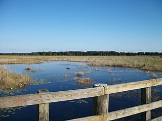
Crews Lake Wilderness Park is located off Shady Hills Road in Pasco County, Florida. The park includes hiking trails, a short paved bike trail, playground, wooden tower, athletic fields, and the 7 1⁄2 in gauge Central Pasco & Gulf Railroad. Rides on the miniature railroad are offered the second Saturday of every month. The lake is the source for the Pithlachascotee River. Jumping Gully Preserve is adjacent to the park.

Starkey Wilderness Preserve is a public recreation and nature conservation area located in Pasco County, Florida. The park includes a system of hiking, bicycling, and equestrian trails, cabins and primitive camping sites, and picnic areas. It is named after Jay B. Starkey, a cattle rancher who bought the property in 1937 and later donated hundreds of acres. The Preserve consists of three tracts: the Jay B. Starkey Wilderness Park, managed by Pasco County, and Serenova Tract and the Anclote River Ranch Tract, managed by Southwest Florida Water Management District. The area includes sections of pine flatwoods, cypress domes, freshwater marshes, stream and lake swamps, sandhill and scrub over a combined 8,500-acre (34 km2) "wetland ecosystem spread throughout approximately 18,000 acres of conservation lands". The park is located in Western Pasco County east of New Port Richey. The park includes the Starkey Trail, an approximately 6.7 mile paved multi-use trail that links up with the Suncoast Trail at its eastern terminus. There are also unimproved trails in the park. An 8-mile mountain bike trail was approved and being developed as of 2013.
Conner Preserve is a natural area in central Pasco County, Florida preserved for water management since 2003. The landscape includes steep sandhill ridges, marshes, cypress sloughs and pine flatwoods and is "part of a wildlife habitat corridor envisioned by Pasco County and the Southwest Florida Water Management District that will eventually connect the Starkey Wilderness Preserve to the Cypress Creek Preserve, making a continuous corridor of several thousands of acres in this region." It is used recreationally for bicycling, horseback riding, hiking, camping, and model airplane flying. The park is located at 22500 on State Road 52 in Land O' Lakes, Florida. It is 2,980 acres (12.1 km2) and open from sunrise to sunset.

Cypress Creek Preserve is a 7,400 acres (3,000 ha) park in Pasco County, Florida at 8720 Pump Station Road in Land O' Lakes, Florida. According to the Southwest Florida Water Management District (SWFWMD) the land was purchased to provide flood protection and as a public water supply. The park includes several trails covering 12 miles (19 km). Habitats include cypress and hardwood forests as well as slash pine, longleaf pine and palmetto in Florida flatwoods. Cypress Creek, a tributary of the Hillsborough River runs through the property. Butterflies, woodpeckers, wild pigs, armadillo, gopher tortoise and several species of bird reside in the park. It is surrounded by a road and grazing lands in an area rapidly populating with suburban housing developments. The park can be accessed along Parkway Boulevard.
Brooker Creek Headwaters Nature Preserve is located in northwest Hillsborough County, Florida and is managed by the Southwest Florida Water Management District. The 1,111-acre (4.50 km2) area is located at 18102 Ramblewood Road in Lutz, Florida and offers hiking opportunities. It protects wetlands and headwaters of the Brooker Creek watershed.
Green Swamp Wilderness Preserve is a 110,000 acre preserve in the four-corner area of Lake County, Pasco County, Polk County and Sumter County, east of Dade City, Florida. It includes a 36-mile section of the Withlacoochee River and offers hiking trails. It is managed by the Southwest Florida Water Management District. It includes various habitats and is home to a wide array of wildlife. The preserve is divided into five areas: 5,067 acre Colt Creek State Park, the 51,149 acre East Tract; the 11,052 acre Hampton Tract; the 4,446 acre Little Withlacoochee Tract; and the 37,350 acre West Tract.
Pasco Palms Preserve is an area of protected lands in the Beacon Square section of New Port Richey in Pasco County, Florida. It is located adjacent to Eagle Point Park to the west of U.S. Highway 19 North at 4466 Strauber Memorial Highway. The 116-acre preserve offers hiking and is open from sunup to sundown. It was acquired in 2009 and includes habitat for bird species, including the white ibis and snowy egret. It fronts on the Gulf of Mexico and includes nature trail with "wetlands, salt marshes, mixed hardwood pine forests, mangrove swamps and tidal flats," according to the Pasco County website Pasco County Environmental Lands Department holds events there, as does Pasco's EcoFest.
Jumping Gully Preserve is an area of protected land in Spring Hill, Florida. The 598 acres (242 ha) are located north of SR 52 and west of U.S. Highway 41 at 18812 Fishburne Drive, northeast of the Crews Lake Wilderness Area. Prescribed burns are used to maintain the property. Access is by scheduled appointment.
Upper Pithlachascotee River Preserve, also referred to as Upper Cotee Preserve, is a 129 acre area of protected land in Pasco County, Florida. It includes 69 acres of bottomland forest by the Pithlachascotee River and the Ryals Branch, a tributary that crosses the site. The park includes a Cypress tree believed to be between 200 and 300 years old, a specimen listed in the Historic Places of Pasco County. It was the first property purchased through the Pasco County's ELAMP program with funding from the "penny for Pasco" sales tax. It includes sandhill habitat, upland mixed forest and freshwater marshes. The Upper Cotee Preserve is located at 17135 Minneola Drive and includes a nature center, boardwalk and hiking trail. The area provides habitat for deer, wild turkey, gopher tortoises, barred owl, red-shouldered hawks, the Florida mouse, gopher frog, little blue heron and snowy egret.
Tierra Del Sol Preserve is a 180 acre area of protected land one mile west of Land O' Lakes Boulevard and two miles south of State Road 52 at 9855 Asbel Road in Land O' Lakes, Florida. It is closed for restoration at present. It was acquired in 2010 to protect a section of the Five Mile Creek wildlife corridor. As of 2013 wetlands in the preserve were being restored and enhanced.
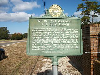
Moon Lake is an unincorporated area in Pasco County, Florida. Moon Lake Road passes through the area. Moon Lake was once home to the Moon Lake Gardens Dude Ranch, built between 1933 and 1937 by the owner of Clearwater, Florida's Fort Harrison Hotel, Ed Haley. The tourist resort included cottages, a casino, and gardens. The community has struggled with a high crime rate and bad reputation in recent years. Moon Lake's elementary school scored an A on state evaluations. It has 75% of its population from lower income homes.
Cypress Creek may refer to:


