States parties
As of 2016, the following states are party to the agreements: [2] [3]
Prior to its dissolution, Czechoslovakia was a party to the agreements. The Czech Republic withdrew from the agreements in 1995 and Slovakia withdrew in 1996.
The DEN/ICE Agreements are a series of multilateral treaties that provide for the joint financing of air traffic control, communications, and meteorological services in Greenland, Iceland, and the Faroe Islands for civil aircraft crossing the North Atlantic Ocean above the 45th parallel north. The agreements were negotiated and are implemented within the International Civil Aviation Organization (ICAO), a specialized agency of the United Nations.
The first joint financing agreement for North Atlantic travel—the Agreement on Joint Financing of Weather Ships on the North Atlantic—was concluded in September 1946. The next year, in April 1947, Canada, France, Iceland, the Netherlands, the United Kingdom, and the United States agreed to jointly finance the continued operation of a LORAN station in Vík, Iceland, that had been established by the British during the Second World War. [1] At Denmark's request, similar agreements were struck in 1949 to allow for joint funding of stations in Greenland and the Faroe Islands. [1]
In 1956, the Agreement on the Joint Financing of Certain Air Navigation Services In Iceland and the Agreement on the Joint Financing of Certain Air Navigation Services In Greenland and the Faroe Islands were concluded in Geneva and were opened to any state that wishes to participate in the funding of aviation services for the North Atlantic. Both agreement entered into force in June 1958. The agreements were updated and amended in 1982 and 2008. The ICAO is the depositary for the agreements.
Under the agreements, Iceland and Denmark contribute five per cent of the operating costs of the aviation services. [1] Since 1974, the operators of aircraft crossing the North Atlantic have been assessed user charges. [1] Any amount that remains to be funded is paid by the states parties to the agreements. Each state party is allocated a percentage of the remaining total which is based on a percentage of North Atlantic crossings that are performed by commercial airlines located in the state. [1]
In 2003, the cost of the arrangements was US$26.7 million; close to 80 per cent of the total funded the services in Iceland, with the remainder going to Greenland and the Faroe Islands. [1]
As of 2016, the following states are party to the agreements: [2] [3]
Prior to its dissolution, Czechoslovakia was a party to the agreements. The Czech Republic withdrew from the agreements in 1995 and Slovakia withdrew in 1996.
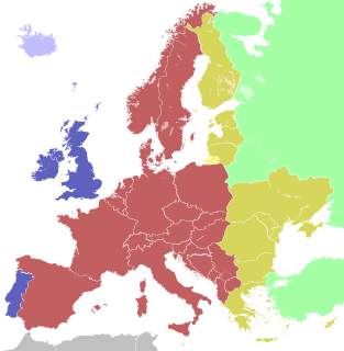
The European Free Trade Association (EFTA) is a regional trade organization and free trade area consisting of four European states: Iceland, Liechtenstein, Norway, and Switzerland. The organization operates in parallel with the European Union (EU), and all four member states participate in the European Single Market and are part of the Schengen Area. They are not, however, party to the European Union Customs Union.
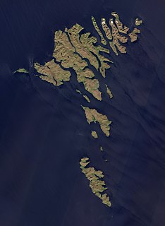
The Faroe Islands are an island group consisting of eighteen islands between the Norwegian Sea and the North Atlantic, about half-way between Iceland and Norway. Its coordinates are 62°N7°W. It is 1,393 square kilometres in area, and includes small lakes and rivers, but no major ones. There are 1,117 kilometres of coastline, and no land boundaries with any other country.
The transportation system in Greenland is very unusual in that Greenland has no railways, no inland waterways, and virtually no roads between towns. Historically the major means of transportation has been by boat around the coast in summer and by dog sled in winter, particularly in the north and east. Nowadays air travel, by helicopter or other aircraft, is the main way of travel.
The defence of Greenland is the responsibility of the Kingdom of Denmark. The government of Greenland does not have control of Greenland's military or foreign affairs. The most important part of Greenland's defensive territory remains the 12 maritime zones. In recent years there has been a significant increase in the presence of new challenges. In the history of Greenland there have been many changes of presence regarding who is in charge of the security of Greenlandic people and its land.
Narsarsuaq is a settlement in the Kujalleq municipality in southern Greenland. It had 123 inhabitants in 2020. There is a thriving tourism industry in and around Narsarsuaq, whose attractions include a great diversity of wildlife, gemstones, tours to glaciers, and an airfield museum.

The ICAOairport code or location indicator is a four-letter code designating aerodromes around the world. These codes, as defined by the International Civil Aviation Organization and published in ICAO Document 7910: Location Indicators, are used by air traffic control and airline operations such as flight planning.

Atlantic Airways is the national airline of the Faroe Islands, operating domestic helicopter services and international passenger services as well as search and rescue responsibilities from its base at Vágar Airport, on the Faroese island of Vágar. Most of its pilots are members of the Faroese Pilot Association.

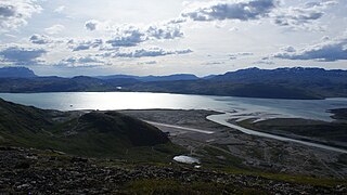
Kangerlussuaq Airport is an airport in Kangerlussuaq, a settlement in the Qeqqata municipality in central-western Greenland. Alongside Narsarsuaq Airport, it is one of only two civilian airports in Greenland large enough to handle large airliners. It is located away from the coast and hence less prone to fog and wind in comparison with other airports in Greenland. Kangerlussuaq Airport is the international hub for Air Greenland. The Kangerlussuaq area has very few inhabitants, so few passengers have their origin or destination here; most passengers change planes.
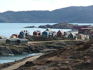
Tasiilaq, formerly Ammassalik and Angmagssalik, is a town in the Sermersooq municipality in southeastern Greenland. With 1,985 inhabitants as of 2020, it is the most populous community on the eastern coast, and the seventh-largest town in Greenland. The Sermilik Station, dedicated to the research of the nearby Mittivakkat Glacier, is located near the town.

Kulusuk Airport is an airport in Kulusuk, a settlement on an island of the same name off the shore of the North Atlantic in the Sermersooq municipality in southeastern Greenland.

The Danish Meteorological Institute is the official Danish meteorological institute, administrated by the Ministry of Energy, Utilities and Climate. The institute makes weather forecasts and observations for Denmark, Greenland, and the Faroe Islands.

Danmarkshavn is a small weather station located in Dove Bay, on the southern shore of the Germania Land Peninsula, in Northeast Greenland National Park, Greenland.
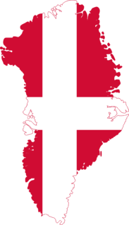
The Danish Realm, officially the Kingdom of Denmark, is a sovereign state located in Europe and North America. It consists of metropolitan Denmark, the kingdom's territory in continental Europe and sometimes called "Denmark proper", and the realm's two autonomous territories: the Faroe Islands and Greenland. The relationship between the three parts of the Kingdom is also known as The unity of the Realm.

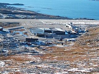
Sondrestrom Air Base, originally Bluie West-8, was a United States Air Force base in central Greenland. The site is located 60 mi (97 km) north of the Arctic Circle and 90 mi (140 km) from the northeast end of Kangerlussuaq Fjord. The base is approximately 11 mi (18 km) west-northwest of Ravneklippen and 80 mi (130 km) east of Sisimiut.

Bluie East Two was a minor United States Army Air Forces airfield at Ikateq in eastern Greenland. It was operational from 1942 to 1947.
DYE Stations were Distant Early Warning Line sites of the DEW Line eastern extension in Arctic North America in Greenland and Iceland. DYE Stations were equipped with the 600 MHz AN/FPS-30 long-range radar within geodesic domes of about 60 feet diameter. Crews were regularly supplied and rotated by C-130 aircraft of the 109th Airlift Wing (NYANG) staging through Sondrestrom Air Base.

The Joint Arctic Command is a direct Level II authority in the Danish Defence. Joint Arctic Command's primary mission in peacetime is to ensure the Unity of the Realm sovereignty by monitoring the area around the Faroe Islands and Greenland. The command also handles tasks such as fisheries inspection, Search and Rescue (SAR), patient transport and other tasks that support the civil society. In short, the Joint Arctic Command handles military tasks, coast guard duties and disaster response - all in one organisation.
Denmark, including the dependencies Faroe Islands and Greenland, uses six time zones.