
In aviation, instrument flight rules (IFR) is one of two sets of regulations governing all aspects of civil aviation aircraft operations; the other is visual flight rules (VFR).
In aviation, visual flight rules (VFR) are a set of regulations under which a pilot operates an aircraft in weather conditions generally clear enough to allow the pilot to see where the aircraft is going. Specifically, the weather must be better than basic VFR weather minima, i.e., in visual meteorological conditions (VMC), as specified in the rules of the relevant aviation authority. The pilot must be able to operate the aircraft with visual reference to the ground, and by visually avoiding obstructions and other aircraft.
The basic principles of air navigation are identical to general navigation, which includes the process of planning, recording, and controlling the movement of a craft from one place to another.

Controlled airspace is airspace of defined dimensions within which air traffic control (ATC) services are provided. The level of control varies with different classes of airspace. Controlled airspace usually imposes higher weather minimums than are applicable in uncontrolled airspace. It is the opposite of uncontrolled airspace.
Airspace is the portion of the atmosphere controlled by a country above its territory, including its territorial waters or, more generally, any specific three-dimensional portion of the atmosphere. It is not the same as outer space which is the expanse or space outside the Earth and aerospace which is the general term for Earth's atmosphere and the outer space within the planet's vicinity.

An air defense identification zone (ADIZ) has existed since February 10, 2003, around the Baltimore-Washington Metropolitan Area to restrict air traffic near Washington, D.C.
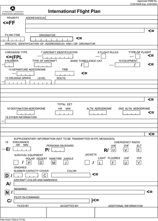
Flight plans are documents filed by a pilot or flight dispatcher with the local Air Navigation Service Provider prior to departure which indicate the plane's planned route or flight path. Flight plan format is specified in ICAO Doc 4444. They generally include basic information such as departure and arrival points, estimated time en route, alternate airports in case of bad weather, type of flight, the pilot's information, number of people on board, and information about the aircraft itself. In most countries, flight plans are required for flights under IFR, but may be optional for flying VFR unless crossing international borders. Flight plans are highly recommended, especially when flying over inhospitable areas such as water, as they provide a way of alerting rescuers if the flight is overdue. In the United States and Canada, when an aircraft is crossing the Air Defense Identification Zone (ADIZ), either an IFR or a special type of VFR flight plan called a DVFR flight plan must be filed. For IFR flights, flight plans are used by air traffic control to initiate tracking and routing services. For VFR flights, their only purpose is to provide needed information should search and rescue operations be required, or for use by air traffic control when flying in a "Special Flight Rules Area."
The world's navigable airspace is divided into three-dimensional segments, each of which is assigned to a specific class. Most nations adhere to the classification specified by the International Civil Aviation Organization (ICAO) and described below, though they might use only some of the classes defined below, and significantly alter the exact rules and requirements. Similarly, individual nations may also designate special use airspace (SUA) with further rules for reasons of national security or safety.

In aviation, instrument meteorological conditions (IMC) are weather conditions that require pilots to fly primarily by reference to flight instruments, and therefore under instrument flight rules (IFR), as opposed to flying by outside visual references under visual flight rules (VFR). Typically, this means flying in cloud or poor weather, where little or nothing can be seen or recognised when looking out of the window. Simulated IMC can be achieved for training purposes by wearing view-limiting devices, which restrict outside vision and force the trainee to rely on instrument indications only.
Special visual flight rules are a set of aviation regulations under which a pilot may operate an aircraft. It is a special case of operating under visual flight rules (VFR).

The Canada Flight Supplement (CFS) is a joint civil/military publication and is a supplement of the Aeronautical Information Publication. It is the nation's official airport directory. It contains information on all registered Canadian and certain Atlantic aerodromes and certified airports.

Allegheny Airlines Flight 853 was a regularly scheduled Allegheny Airlines flight from Boston, Massachusetts, to St. Louis, Missouri, with stops in Baltimore, Maryland, Cincinnati, Ohio, and Indianapolis, Indiana. On September 9, 1969, the aircraft serving the flight, a McDonnell Douglas DC-9, collided in mid-air with a Piper PA-28 light aircraft near Fairland, Indiana. The DC-9 was carrying 78 passengers and 4 crew members, and the Piper was leased to a student pilot on a solo cross-country flight. All 83 occupants of both aircraft were killed in the accident and both aircraft were destroyed.
VFR over-the-top (OTT) refers to flying over top of clouds in visual flight, rather than with reference to instruments. This is usually done for brief amount of time to avoid weather or turbulence.
Leesburg Executive Airport at Godfrey Field is a town-owned public-use airport located three nautical miles south of the central business district of Leesburg, a town in Loudoun County, Virginia.

Special use airspace (SUA) is a type of special airspaces in the United States designated for operations of a nature such that limitations may be imposed on aircraft not participating in those operations. Often these operations are of a military nature. The designation of SUAs identifies for other users the areas where such activity occurs, provides for segregation of that activity from other users, and allows charting to keep airspace users informed of potential hazards.
In United States aviation, a special flight rules area (SFRA) is a region in which the normal regulations of flight do not apply in whole or in part, especially regulations concerning airspace classification, altitude, course, and speed restrictions, and the like.

The Air Defense Identification Zone of North America is an air defense identification zone (ADIZ) that covers the airspace surrounding the United States and Canada – in which the ready identification, location, and control of civil aircraft over land or water is required in the interest of national security. This ADIZ is jointly administered by the civilian air traffic control authorities and the militaries of both nations, under the auspices of the North American Aerospace Defense Command (NORAD). The Federal Aviation Administration (FAA) handles the requests of international aircraft and Transport Canada handles Canadian requests. Any aircraft flying in these zones without authorization may be identified as a threat and treated as an enemy aircraft, potentially leading to interception by fighter aircraft.

Golden West Airlines Flight 261, a de Havilland Canada DHC-6 Twin Otter, collided with a Cessna 150 (N11421), owned by CessnAir Aviation, Inc., near Whittier, California. The accident occurred on January 9, 1975, at approximately 4:07 p.m. PST, while the Sun was just 9 degrees above the western horizon, directly into the eyes of the pilots of GW flight 261.
An air defense identification zone (ADIZ) is a region of airspace in which a country tries to identify, locate, and control aircraft in the interest of national security. It is declared unilaterally and may extend beyond a country's territory to give the country more time to respond to possibly hostile aircraft. The concept of an ADIZ is not defined in any international treaty and is not recognized by any international body.

The East China Sea Air Defense Identification Zone is an air defense identification zone covering most of the East China Sea where the People's Republic of China announced that it was introducing new air traffic restrictions in November 2013. The area consists of the airspace from about, and including, the Japanese controlled Senkaku Islands north to South Korean-claimed Socotra Rock. About half of the area overlaps with a Japanese ADIZ, while also overlapping to a small extent with the South Korean and Taiwanese ADIZ. When introduced the Chinese initiative drew criticism as the ADIZ overlapped with the ADIZ of other countries, imposed requirements on both civilian and military aircraft regardless of destination, and included contested maritime areas