Dalmusternock, East Ayrshire

Last updated
Dalmusternock
Fenwick, East Ayrshire, Scotland
UK grid reference NS455417
Dalmusternock Farm.JPG
Dalmusternock Farm
East Ayrshire UK location map.svg
Red pog.svg
Dalmusternock
Coordinates 55°38′39″N4°27′19″W / 55.6441°N 4.4554°W / 55.6441; -4.4554
Site information
OwnerPrivate
Controlled by Mure family
Open to
the public
No
ConditionOccupied
Site history
Built17th century
Built byMures
In useRemodelled in the 19th century
Materialsstone

Dalmusternock (NS455417) was a dower house built and occupied by William Mure after his marriage and prior to inheriting the family seat of Rowallan Castle. The property is located near Fenwick, in the Barony of Rowallan, lying 3 miles north of Kilmarnock and 18 miles south of Glasgow, Parish of Fenwick, East Ayrshire, Scotland. The estate is recorded as Dalmunsternoch circa 1654; [1] Dalmasternock circa 1747; [2] Dalmusterknok 1775 [3]

Dower house UK term for a large house available to an estate owners widow

On an English, Scottish or Welsh estate, a dower house is usually a moderately large house available for use by the widow of the previous owner of the estate. The widow, often known as the "dowager", usually moves into the dower house from the larger family house on the death of her husband if the heir is married, and upon his marriage if he was single at his succession. The new heir occupies the now vacated principal house.

Sir William Mure of Rowallan (1594–1657) was a Scottish writer and politician, and prominent member of the Clan Muir.

Rowallan Castle

Rowallan Castle is an ancient castle located near Kilmaurs, about 5 kilometres (3.1 mi) north of Kilmarnock, East Ayrshire, Scotland. The castle stands on the banks of the Carmel Water, which may at one time have run much closer to the low eminence upon which the original castle stood, justifying the old name Craig of Rowallan. Elizabeth Mure was mistress and then wife of Robert, High Steward of Scotland, and Guardian of Scotland, who later became King Robert II of Scotland. She may have been born at Rowallan.

Contents

History

The Lands of Dalmusternock

William Aiton's map of 1811 showing Dalmusternock and Rowallan. Map of Dunduff castle & roads.jpg
William Aiton's map of 1811 showing Dalmusternock and Rowallan.

In 1615 the poet Sir William Mure of Rowallan Castle married Anna Dundas, the daughter of the laird of Newliston, an estate located near Edinburgh. William was the son of Elizabeth Montgomerie, sister of the well known poet Alexander Montgomerie of Hessilhead Castle near Beith. In 1643 William Mure was a member of the Scottish parliament through which the Solemn League and Covenant was ratified with England and took part in the English campaign of 1644. He fought and was wounded at the Battle of Marston Moor, shortly after commanding a regiment at Newcastle.

Newliston

Newliston is a country house near Edinburgh, Scotland. It is located 1 mile (1.6 km) south-west of Kirkliston, and 8 miles (13 km) west of the city centre. The house, designed by Robert Adam in the late 18th century, is a category A listed building. The 18th-century gardens, inspired by the French formal style, are included in the Inventory of Gardens and Designed Landscapes in Scotland, the listing of nationally significant gardens. Newliston is within the City of Edinburgh council area and the historic county of West Lothian.

Alexander Montgomerie Scottish courtier and poet

Alexander Montgomerie was a Scottish Jacobean courtier and poet, or makar, born in Ayrshire. He was one of the principal members of the Castalian Band, a circle of poets in the court of James VI in the 1580s which included the king himself. Montgomerie was for a time in favour as one of the king's "favourites". He was a Catholic in a largely Protestant court and his involvement in political controversy led to his expulsion as an outlaw in the mid-1590s.

Hessilhead human settlement in United Kingdom

Hessilhead is in Beith, North Ayrshire, Scotland. Hessilhead used to be called Hazlehead or Hasslehead. The lands were part of the Lordship of Giffen, and the Barony of Hessilhead, within the Baillerie of Cunninghame and the Parish of Beith. The castle was situated at grid reference NS380532.

As a first home or dower house he built Dalmusternock in 1615 for although he was the eldest son he had not as yet inherited the family properties and would not do so until 1639. Dalmusternock is in an attractive location on the Fenwick Water within easy reach of the family seat at Rowallan Castle. The coat of arms of Sir William and his wife are still located above the entrance door. The 1615 date of his marriage is carved on a stone to the right of the doorway with the initials A. D. for his wife Anna Dundas on a stone to the left. [4]

Five sons and six daughters came of this first marriage, namely William who succeeded, Captain Allexander who was killed fighting rebels in Ireland, Major Robert who married Lady Newhall in Fife, John of Fenwickhill and Patrick, who in 1662 was created a baronet of Nova Scotia. Only one daughter, Elizabeth, reached maturity and married Uchter Knox, Laird of Ranfurly. His first wife Anna died comparatively young and Sir William then married Dame Jane Hamilton, Lady Duntreth, having two sons, James and Hugh and two daughters, Jeane and Marion from this union. [5]

Nova Scotia Province of Canada

Nova Scotia is one of Canada's three Maritime Provinces, and one of the four provinces that form Atlantic Canada. Its provincial capital is Halifax. Nova Scotia is the second-smallest of Canada's ten provinces, with an area of 55,284 square kilometres (21,300 sq mi), including Cape Breton and another 3,800 coastal islands. As of 2016, the population was 923,598. Nova Scotia is Canada's second-most-densely populated province, after Prince Edward Island, with 17.4 inhabitants per square kilometre (45/sq mi).

Ranfurly, Renfrewshire village in United Kingdom

Ranfurly is a small settlement on the southern edge of the village of Bridge of Weir, which lies within the Gryffe Valley in the council area and historic county of Renfrewshire in the West-Central Lowlands of Scotland.

In 1616 his father inherited the family estates and in 1639 he in turn inherited at which point he moved to Rowallan Castle and Dalmusternock remained as a small dower house before its final transition to a farmhouse. [6]

Dobie records that it was the property of the Marquis of Hastings and by 1874 it was part of the Barony of Rowallan then held by the Earl of Loudoun. [7] As stated it was used as a dower house by the Mures of nearby Rowallan Castle although it is not recorded as to which members of the family lived there. [8] Three heraldic panels are inserted, one with a date of 1671. It was remodelled as a farmhouse in the 19th century. [9]

Earl of Loudoun

Earl of Loudoun, named after Loudoun in Ayrshire, is a title in the Peerage of Scotland. It was created in 1633 for John Campbell, 2nd Lord Campbell of Loudoun, along with the subsidiary title Lord Tarrinzean and Mauchline. The 1st Earl's wife Margaret was the granddaughter and heiress of Hugh Campbell, who had been created Lord Campbell of Loudoun; he resigned the peerage in favour of his grandson-in-law, who was later created an earl.

A watermill of some sort was located at Dalmusternock in the 19th century as indicated by the lade, sluice and mill pond shown on OS maps of the time. [10] [11] Hugh Robertson was farming 129 acres at Dalmusternock in 1851 showing that the dower house had been remodelled by this time. [12]

Bessie Dunlop of the Lynn

Bessie Dunlop of Lynn near Dalry recalled at her trial for witchcraft that a meeting with her 'familiar' Thomas Reid at a place known as the 'Thorn of Dawmstarnik.' This was probably Dalmusternock as it lies on the Stranraer to Glasgow road via Kilmarnock that would have been a busy thoroughfare which Bessie might well have used. [13] Thomas offered her great rewards if she would deny her Christian faith however Bessie refused and Thomas was very displeased however she said that she would take his advice on lesser matters. [14] Bessie Dunlop was burned at the stake in Edinburgh as a witch in 1576.

Cartographic evidence

The old Rowallan Castle in 1876. Rowallan castle ayrshire.jpg
The old Rowallan Castle in 1876.

Pont's map of circa 1600 shows a small wooded estate surrounded by a fence or pale. [15] Moll's 1725 map shows the Glasgow to Stranraer road running close to Dalmusternock. [16] Roys map of 1747 shows Dalmasternock (sic) lying close to the Glasgow to Stranraer Road and a dwelling known as 'Stepends' which may relate to stepping stones across the Mathernock (later Fenwick) Water. [17] The 1856 OS map shows a long lade running upstream and a sluice that suggests a waterwheel. [18] The 1895 OS records a mill pond in addition to the other noted features. [19]

Micro-history

In 1684 John Kirkland and Thomas Rainie are listed as Covenanters on the fugitives roll as living at Dalmusterlock. [20]

James Miller, son to Mathew Miller and Mary Smith of Dalmusternock was buried in Fenwick cemetery on Tuesday, 1 August 1749. [21] Sara Steill of Dalmusternock was buried on Monday, June 24, 1723. [22]

In March 1851 Hugh Robertson, aged 36, was farming 129 acres at Dalmusternock. [23]

Dalmusternock is a Category B Listed Building.

Related Research Articles

Stewarton town in East Ayrshire, Scotland

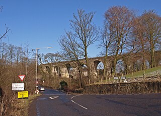
Stewarton is a town in East Ayrshire, Scotland. In comparison to the neighbouring towns of Kilmaurs, Fenwick, Dunlop and Lugton, it is a relatively large town, with a population of over 6,500. It is 300 feet above sea level. The town is served by Stewarton railway station.

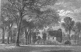
Perceton is a medieval settlement and old country estate in North Ayrshire, Scotland, near the town of Irvine. The ruined church in Perceton is one of the oldest buildings in the Irvine district. The earliest legible gravestone dates from 1698, though older stone coffins will certainly still rest deep within the small hillock on which the chapel and graveyard sit.

Cunninghamhead is a hamlet in North Ayrshire, Scotland. It was the centre of the lands of Cunninghamhead, Perceton and Annick Lodge in Cunninghame. This mainly rural area is noted for its milk and cheese production and the Ayrshire, Cunninghame or Dunlop breed of cattle.

Lugton hamlet in East Ayrshire, Scotland

Lugton is a small village or hamlet in East Ayrshire, Scotland with a population of 80 people. The A736 road runs through on its way from Glasgow, 15 miles (24.1 km) to the north, to Irvine in North Ayrshire. Uplawmoor is the first settlement on this 'Lochlibo Road' to the north and Burnhouse is to the south. The settlement lies on the Lugton Water which forms the boundary between East Ayrshire and East Renfrewshire as well as that of the parishes of Dunlop and Beith.

Kerelaw Castle building in Stevenston, Scotland

Kerelaw Castle is a castle ruin situated on the coast of North Ayrshire, Scotland in the town of Stevenston.

A marriage stone, nuptial stone or lintel stone is usually a stone, rarely wood, lintel carved with the initials, coat of arms, etc. of a newly married couple, usually displaying the date of the marriage. They were very popular until Victorian times, but fell out of general use in the 20th century. Many survive for aesthetic value particularly where well carved or of historic value. Many are part of or in the grounds of a listed building or in conservation areas.

River Irvine river in the United Kingdom

The River Irvine is a river that flows through southwest Scotland. Its watershed is on the Lanarkshire border of Ayrshire at an altitude of 810 feet (250 m) above sea-level, near Loudoun Hill, Drumclog, and 7 miles (11 km) SW by W of Strathaven. It flows 29½ miles westward, dividing the old district of Cunninghame from that of Kyle, until it reaches the sea via Irvine Harbour in the form of the Firth of Clyde, and flows into Irvine Bay by the town of Irvine. It has many tributaries, some of which form parish, district and other boundaries.

Clan Muir

Clan Muir is a Scottish clan that is armigerous. Historically, holders of the surname Muir can be considered septs of Clan Campbell and septs of Clan Gordon in the highlands. The spelling variation More/Moore is a sept of Clan Leslie in Aberdeenshire. Some members of Clan Muir who trace their ancestry to Ayrshire are septs of Clan Boyd. A single family, the Mores of Drumcork, are septs of Clan Grant.

Kilmaurs Castle

Kilmaurs Castle was located on the lands of Jocksthorn Farm near Kilmaurs in East Ayrshire, Scotland. It is described by Timothy Pont in the early 17th century as "Ye castell is ane ancient ftronge building belonging to ye Earls of Glencairne environed with a fair park called Carmell wod from ye vatter of Carmell yat runs by it." Dobie goes on to state that "The old baronial manor place is supposed to have been situated about a mile south-east of Kilmaurs, where some ruins can still be pointed out on the farm of Jock's-thorn, probably the original Villam de Cuninghame - the first possession of the family." The castle is not to be confused with the later Cunninghame family possession known as Kilmaurs Place which Dobie calls "..comparatively modern" in 1876.

Caldwell, East Renfrewshire

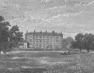
Caldwell is a mansion and old estate with the remains of a castle nearby. These lands lie close to the Lugton Water and the villages of Uplawmoor in East Renfrewshire and Lugton in East Ayrshire.

Busbie Castle village in the United Kingdom

Busbie Castle was situated in what is now known as Knockentiber, a village in East Ayrshire, Parish of Kilmaurs, Scotland. Knockentiber is 2 miles (3.2 km) WNW of Kilmarnock and 1/2 mile NE of Crosshouse. The castle overlooked the Carmel Glen and its Burn, which runs into the River Irvine, a mile or so to the south, after passing through the old Busbie Mill.

Giffordland Barony in North Ayrshire, United Kingdom

Giffordland is in North Ayrshire, Parish of Dalry (Cunninghame) in the former Region of Strathclyde, Scotland.

Craigie Castle

Craigie Castle, in the old Barony of Craigie, is a ruined fortification situated about 4 miles (6.4 km) southeast of Kilmarnock and 1 mile (1.6 km) southeast of Craigie village, in the Civil Parish of Craigie, South Ayrshire, Scotland. The castle is recognised as one of the earliest buildings in the county. It lies about 1.25 miles (2 km) west-south-west of Craigie church. Craigie Castle is protected as a scheduled monument.

Hessilhead Loch lake in the United Kingdom

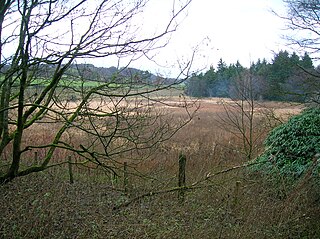
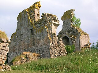
Hessilhead Loch or Hazelhead Loch was situated in a low-lying area near the old Castle of Hessilhead in the Parish of Beith, North Ayrshire, Scotland. The old loch, used in the defence of the castle, was probably infilled when the castle ruins were landscaped in the 19th century.

Polkelly Castle

Polkelly Castle, also Pokelly, was an ancient castle located near Fenwick, at NS 4568 4524, in the medieval free Barony of Polkelly, lying north of Kilmarnock, Parish of Fenwick, East Ayrshire, Scotland. The castle is recorded as Powkelly (c1747), Pockelly (c1775), Pow-Kaillie, Ponekell, Polnekel, Pollockelly, Pollockellie, Pokellie, Pothelly, Pathelly Ha' and Polkelly. The name is given circa 1564 as Powkellie when it was held by the Cunninghams of Cunninghamhead.

Murder of Hugh Montgomerie

The Murder of Hugh Montgomerie, 4th Earl of Eglinton at the Annick Ford in Stewarton, East Ayrshire, Scotland, took place in 1586 as a consequence of a long running feud between the Montgomeries, Earls of Eglinton and the Cunninghames, Earls of Glencairn, families who were competing for power and influence locally and nationally. The significant repercussions of this act were felt throughout the county of Ayrshire and beyond. The spelling 'Montgomerie' is used throughout for both the family and Montgomery for the clan and clan and district names 'Cunninghame' in the same fashion.

Lands of Tour and Kirkland

The Lands of Tour and Kirkland (NS416406) formed a small estate close to the old Kirktoun and St Maurs-Glencairn collegiate church about 1 km south-east of Kilmaurs, East Ayrshire, Parish of Kilmaurs, Scotland. The word 'Tour' in Scots refers to a 'tower' and 'kirk' to a parish church.

References

Notes
Sources
  1. Dobie, James D. (ed Dobie, J.S.) (1876). Cunninghame, Topographized by Timothy Pont 1604–1608, with continuations and illustrative notices. Glasgow : John Tweed.
  2. Scott, Sir Walter (2001). Letters on Demonology and Witchcraft. The Folklore Society & Wordsworth Editions. ISBN   1-84022-511-4.

See also