Dartmouth North Community Centre

Last updated
Dartmouth North Community Centre Dncc.jpg
Dartmouth North Community Centre

Dartmouth North Community Centre is a Community centre in Albro Lake a neighbourhood in the north end of the community of Dartmouth in Nova Scotia's Halifax Regional Municipality. Albro Lake is also known as District 9.

Albro Lake, Nova Scotia Neighbourhood in Halifax Regional Municipality, Nova Scotia, Canada

Albro Lake is a neighbourhood in the north end of the community of Dartmouth in Nova Scotia's Halifax Regional Municipality.

Dartmouth, Nova Scotia Community in Nova Scotia, Canada

Dartmouth is a former city and current community located in the Halifax Regional Municipality of Nova Scotia, Canada. Dartmouth is located on the eastern shore of Halifax Harbour. Dartmouth has been nicknamed the City of Lakes, after the large number of lakes located within its boundaries.

Nova Scotia Province of Canada

Nova Scotia is one of Canada's three Maritime Provinces, and one of the four provinces that form Atlantic Canada. Its provincial capital is Halifax. Nova Scotia is the second-smallest of Canada's ten provinces, with an area of 55,284 square kilometres (21,300 sq mi), including Cape Breton and another 3,800 coastal islands. As of 2016, the population was 923,598. Nova Scotia is Canada's second-most-densely populated province, after Prince Edward Island, with 17.4 inhabitants per square kilometre (45/sq mi).

Contents

The DNCC

The Dartmouth North Community Center was officially opened on March 22, 1996, at its past location on 134 Pinecrest Drive. The Centre is now located at 105 Highfield Park Drive in Dartmouth. The center was created through a cooperative effort between the municipal, provincial, federal governments through the Canada/Nova Scotia Infrastructure Work Program, which allotted $1.7 million to build the facility and created twenty jobs at the time of the centre's initial opening. [1] The center has expanded since its opening and offers a variety of services, programs and resources to the community which includes a C@P site, job search services, seniors activities, and children's and youth activities. There is also a branch of Halifax Regional Library an office of the Halifax Regional Police as well as the Department of Parks and Recreation in the building.

Provinces and territories of Canada Top-level subdivisions of Canada

The provinces and territories of Canada are sub-national divisions within the geographical areas of Canada under the jurisdiction of the Canadian Constitution. In the 1867 Canadian Confederation, three provinces of British North America—New Brunswick, Nova Scotia, and the Province of Canada —were united to form a federated colony, becoming a sovereign nation in the next century. Over its history, Canada's international borders have changed several times, and the country has grown from the original four provinces to the current ten provinces and three territories. Together, the provinces and territories make up the world's second-largest country by area.

The Government of Canada, officially Her Majesty's Government, is the corporation responsible for the federal administration of Canada. In Canadian English, the term can mean either the collective set of institutions or specifically the Queen-in-Council. In both senses, the current construct was established at Confederation through the Constitution Act, 1867—as a federal constitutional monarchy, wherein the Canadian Crown acts as the core, or "the most basic building block", of its Westminster-style parliamentary democracy. The Crown is thus the foundation of the executive, legislative, and judicial branches of the Canadian government. Further elements of governance are outlined in the rest of the Canadian Constitution, which includes written statutes, court rulings, and unwritten conventions developed over centuries.

Halifax Public Libraries public library system in Nova Scotia

Halifax Public Libraries (HPL) is a Canadian public library system serving residents of Halifax, Nova Scotia. It is the largest public library system in Nova Scotia, with over 2.8 million visits to library branches and 172,520 active registered borrowers or 44% of the municipality's population. With roots that trace back to the establishment of the Citizens' Free Library in 1864, the current library system was created in 1996 during municipal amalgamation, and now consists of 14 branches and a collection of almost 1 million items.

History of the community

First occupants of the area were industrial workers as this area was the location for several industrial factories. The industrial factories were set up in the early 19th century by John Albro and his brother Samuel (after whom the community is named). The two brothers established the area as an industrial hub with a nail factory, tannery and barking mill. [2] The Naval Radio Station in Albro Lake is another feature of the community. It served as a naval radio communications station for the Atlantic Coast set up in 1942. The site was developed in order to cope with the North Atlantic U-boat threat in WWII. The site was renamed HMC NRS Albro Lake on July 1, 1956, and remained such until its closure in 1968. [3] Near the end of WWII the area was a residential subdivision until 1961 when it was amalgamated into the city of Dartmouth [4]

John Albro Merchant, political figure

John Albro was a merchant and political figure in Nova Scotia. He represented Halifax Township in the Nova Scotia House of Assembly from 1818 to 1826. He was also a Lieutenant-Colonel of the 4th Regiment of Halifax militia.

Naval Radio Station Albro Lake was a naval radio station operated by the Royal Canadian Navy (RCN).

World War II 1939–1945, between Axis and Allies

World War II, also known as the Second World War, was a global war that lasted from 1939 to 1945. The vast majority of the world's countries—including all the great powers—eventually formed two opposing military alliances: the Allies and the Axis. A state of total war emerged, directly involving more than 100 million people from more than 30 countries. The major participants threw their entire economic, industrial, and scientific capabilities behind the war effort, blurring the distinction between civilian and military resources. World War II was the deadliest conflict in human history, marked by 70 to 85 million fatalities, most of whom were civilians in the Soviet Union and China. It included massacres, the genocide of the Holocaust, strategic bombing, premeditated death from starvation and disease, and the only use of nuclear weapons in war.

Neighbouring schools

Related Research Articles

Halifax, Nova Scotia Municipality in Nova Scotia, Canada

Halifax, officially known as the Halifax Regional Municipality (HRM), is the capital of the Canadian province of Nova Scotia. It had a population of 403,131 in 2016, with 316,701 in the urban area centred on Halifax Harbour. The regional municipality consists of four former municipalities that were amalgamated in 1996: Halifax, Dartmouth, Bedford, and Halifax County.

Bedford, Nova Scotia Urban Community in Nova Scotia, Canada

Bedford is a suburban community of Halifax, Nova Scotia, Canada. It was an independent town from 1980 to 1996. Bedford is on the northwestern end of Bedford Basin, an extension of the Halifax Harbour, which ends just before Nova Scotia Highway 102 and the Bedford Bypass, next to Lower Sackville. Bedford is at the junctions of Trunks 1, 2, and 7.

Spryfield, Nova Scotia

Spryfield is an unincorporated suburban community in Halifax, Nova Scotia, Canada. It was founded about 1770, by Captain William Spry, who purchased land there and established the settlement with the aid of stationed soldiers from the nearby Halifax garrison. In 1783, he sold the property and returned to England. The name "Spryfield" is also sometimes used to refer to the general area of Halifax's South Mainland, which includes a number of communities along the Herring Cove and Purcell's Cove Roads.

Eastern Passage, Nova Scotia Suburban Community in Halifax Regional Municipality, Nova Scotia, Canada

Eastern Passage is an unincorporated suburban community in Halifax Regional Municipality Nova Scotia, Canada.

Shubenacadie Canal Manmade watercourse in Canada

The Shubenacadie Canal is a Canadian canal in central Nova Scotia, linking Halifax Harbour with the Bay of Fundy by way of the Shubenacadie River and Shubenacadie Grand Lake. Begun in 1826, it was not completed until 1861 and was closed in 1871. Currently small craft use the river and lakes, but only one lock is operational. Three of the nine locks have been restored to preserve their unique fusion of British and North American construction techniques. More extensive restoration is planned.

Cole Harbour, Nova Scotia Suburban and Rural Community in Halifax Regional Municipality, Nova Scotia, Canada

Cole Harbour is a former unincorporated village and unincorporated community located in the Halifax Regional Municipality in Nova Scotia, Canada.

The Eastern Shore is a region of the Canadian province of Nova Scotia. It is the Atlantic coast running northeast from Halifax Harbour to the eastern end of the peninsula at the Strait of Canso.

Highfield Park, Nova Scotia Neighborhood in Halifax Regional Municipality, Nova Scotia, Canada

Highfield Park is a neighborhood located in the north end of the community of Dartmouth in Nova Scotia's Halifax Regional Municipality.

Nova Scotia Route 207 highway in Nova Scotia

Route 207 is a collector road in the Canadian province of Nova Scotia. It is located in the Halifax Regional Municipality and connects Dartmouth to Porters Lake on the Eastern Shore.

Woodside, Nova Scotia Locality in Nova Scotia, Canada

Woodside is an unincorporated middle income urban locality of Dartmouth, within the Halifax Regional Municipality, Nova Scotia. The community is divided into North Woodside and South Woodside. Woodside is home to two hospitals: the Dartmouth General Hospital and the Nova Scotia Hospital.

Sheet Harbour, Nova Scotia Rural Community in Nova Scotia, Canada

Sheet Harbour is a rural community on the Eastern Shore of Nova Scotia, Canada. It is located in the eastern reaches of the Halifax Regional Municipality, approximately 117 km (73 mi) northeast of the central urban area of the municipality, concentrated on Downtown Halifax and Dartmouth. The community is located along the Marine Drive scenic route on Trunk 7 at its junctions with Route 224 and Route 374. Surrounding the branched harbour which its name is derived from, the community has a population of about 800 and its respective census tract, containing sizable amounts of land around the community, has a population of 3,478 as of the 2011 Census. Two rivers, West River and East River, flow through the community and into the Northwest and Northeast Arms of the harbour respectively. The coastline of the community is heavily eroded and the region in which the community is located has an abundance of lakes. The region has a humid continental climate, congruent with the majority of Nova Scotia, and the ocean significantly influences the temperature.

Westphal is an unincorporated suburban and rural community located in Dartmouth, Nova Scotia and outside of Dartmouth, Nova Scotia. Some of Westphal is considered part of Dartmouth, Nova Scotia and some of it is considered separate from Dartmouth, Nova Scotia. The area is bound by Port Wallace in the north, Waverley Road in the west, Lake Major Road in the east and Main Street in the south. The area also includes the watershed and water filtration plant for the Halifax Regional Water Commission that supplies drinking water for the residents of Dartmouth and surrounding communities east of Halifax Harbour. It is named after two Westphal brothers who became admirals in the British navy and who hailed from this part of Nova Scotia - George Augustus Westphal and his elder brother Philip. Their surname is of German origin.

Robie Street

Robie Street is a north-south artery, street and provincial road that runs for 7 kilometres within the Halifax Peninsula area of the Halifax Regional Municipality, from Memorial Drive in the North End Halifax, to Gorsebrook Avenue in the South End. The street in most places is 4 lanes wide with a centre median from Gorsebrook Ave to Cunard Street. From Cunard to Almon Streets, it is a 2-lane street.

Naval Radio Section Newport Corner

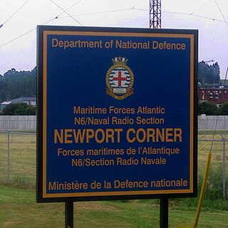
Naval Radio Section Newport Corner is a Canadian Forces naval radio station located in Brooklyn, Nova Scotia. Founded in 1942, it is still in operation today but remotely controlled from CFB Halifax.

Canadian Forces Station Mill Cove is a former Canadian Forces Station and currently a naval radio station located near Hubbards, Nova Scotia. Built in 1967, it is remotely operated by the Canadian Forces from CFB Halifax.

Russell Lake West is a planned residential subdivision and commercial development in the eastern part of the community of Dartmouth in the Halifax Regional Municipality, Nova Scotia. The area began construction in 2006 with the creation of Exit 8 on Highway 111, providing access from the southwest to the area via Mount Hope Avenue, which as of October 2011, Exit 8 also provides direct access into the Woodside Industrial Park. Russell Lake West is located next to the community of Woodside and a park and walking trails provide direct access to and from Woodside.

References

  1. Atlantic Canada Opportunities Agency
  2. Chapman, Harry.The Dartmouthians; Footprints in the Sands of Time, 1750-2005, Dartmouth: Dartmouth Historical Association, 2005, pp.30.
  3. Naval Radio Station (NRS) Albro Lake
  4. Public Achieves of Nova Scotia

Coordinates: 44°41′02.33″N63°35′19.37″W / 44.6839806°N 63.5887139°W / 44.6839806; -63.5887139

Geographic coordinate system Coordinate system

A geographic coordinate system is a coordinate system that enables every location on Earth to be specified by a set of numbers, letters or symbols. The coordinates are often chosen such that one of the numbers represents a vertical position and two or three of the numbers represent a horizontal position; alternatively, a geographic position may be expressed in a combined three-dimensional Cartesian vector. A common choice of coordinates is latitude, longitude and elevation. To specify a location on a plane requires a map projection.