External links
- Depth conversion definition in the Oilfield Glossary
| | This seismology article is a stub. You can help Wikipedia by expanding it. |
Depth conversion is an important step of the seismic reflection method, which converts the acoustic wave travel time to actual depth, based on the acoustic velocity of subsurface medium (sediments, rocks, water).
Depth conversion integrates several sources of information about the subsurface velocity to derive a three-dimensional velocity model:
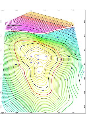
The conversion permits the production of depth and thickness maps that depict subsurface layers that are based on reflection data. These maps are crucial in hydrocarbon exploration because they permit the volumetric evaluation of gas or oil in place. In the example subsurface map presented below, depth increases from red to blue. The highest zone in red is an oilfield at approximately 3000 m below sea level.
| | This seismology article is a stub. You can help Wikipedia by expanding it. |
Petroleum geology is the study of origin, occurrence, movement, accumulation, and exploration of hydrocarbon fuels. It refers to the specific set of geological disciplines that are applied to the search for hydrocarbons.
In petroleum exploration and development, formation evaluation is used to determine the ability of a borehole to produce petroleum. Essentially, it is the process of "recognizing a commercial well when you drill one".

Hydrocarbon exploration is the search by petroleum geologists and geophysicists for deposits of hydrocarbons, particularly petroleum and natural gas, in the Earth's crust using petroleum geology.

Reflection seismology is a method of exploration geophysics that uses the principles of seismology to estimate the properties of the Earth's subsurface from reflected seismic waves. The method requires a controlled seismic source of energy, such as dynamite or Tovex blast, a specialized air gun or a seismic vibrator. Reflection seismology is similar to sonar and echolocation.
Well logging, also known as borehole logging is the practice of making a detailed record of the geologic formations penetrated by a borehole. The log may be based either on visual inspection of samples brought to the surface or on physical measurements made by instruments lowered into the hole. Some types of geophysical well logs can be done during any phase of a well's history: drilling, completing, producing, or abandoning. Well logging is performed in boreholes drilled for the oil and gas, groundwater, mineral and geothermal exploration, as well as part of environmental and geotechnical studies.
The Kansas Geological Survey (KGS), a research and service division of the University of Kansas, is charged by statute with studying and providing information on the geologic resources of Kansas. The KGS has no regulatory authority and does not take positions on natural resource issues.

In geophysics and reflection seismology, amplitude versus offset (AVO) or amplitude variation with offset is the general term for referring to the dependency of the seismic attribute, amplitude, with the distance between the source and receiver. AVO analysis is a technique that geophysicists can execute on seismic data to determine a rock's fluid content, porosity, density or seismic velocity, shear wave information, fluid indicators.
Exploration geophysics is an applied branch of geophysics and economic geology, which uses physical methods at the surface of the Earth, such as seismic, gravitational, magnetic, electrical and electromagnetic, to measure the physical properties of the subsurface, along with the anomalies in those properties. It is most often used to detect or infer the presence and position of economically useful geological deposits, such as ore minerals; fossil fuels and other hydrocarbons; geothermal reservoirs; and groundwater reservoirs. It can also be used to detect the presence of unexploded ordnance.

Magnetotellurics (MT) is an electromagnetic geophysical method for inferring the earth's subsurface electrical conductivity from measurements of natural geomagnetic and geoelectric field variation at the Earth's surface.
Seismic anisotropy is the directional dependence of the velocity of seismic waves in a medium (rock) within the Earth.
Petrophysics is the study of physical and chemical rock properties and their interactions with fluids.
Seismic migration is the process by which seismic events are geometrically re-located in either space or time to the location the event occurred in the subsurface rather than the location that it was recorded at the surface, thereby creating a more accurate image of the subsurface. This process is necessary to overcome the limitations of geophysical methods imposed by areas of complex geology, such as: faults, salt bodies, folding, etc.
In geophysics, seismic inversion is the process of transforming seismic reflection data into a quantitative rock-property description of a reservoir. Seismic inversion may be pre- or post-stack, deterministic, random or geostatistical; it typically includes other reservoir measurements such as well logs and cores.
Heavy oil production is a developing technology for extracting heavy oil in industrial quantities. Estimated reserves of heavy oil are over 6 trillion barrels, three times that of conventional oil and gas.
A synthetic seismogram is the result of forward modelling the seismic response of an input earth model, which is defined in terms of 1D, 2D or 3D variations in physical properties. In hydrocarbon exploration this is used to provide a 'tie' between changes in rock properties in a borehole and seismic reflection data at the same location. It can also be used either to test possible interpretation models for 2D and 3D seismic data or to model the response of the predicted geology as an aid to planning a seismic reflection survey. In the processing of wide-angle reflection and refraction (WARR) data, synthetic seismograms are used to further constrain the results of seismic tomography. In earthquake seismology, synthetic seismograms are used either to match the predicted effects of a particular earthquake source fault model with observed seismometer records or to help constrain the Earth's velocity structure. Synthetic seismograms are generated using specialized geophysical software.
In the oil and gas industry, reservoir modeling involves the construction of a computer model of a petroleum reservoir, for the purposes of improving estimation of reserves and making decisions regarding the development of the field, predicting future production, placing additional wells and evaluating alternative reservoir management scenarios.

Geothermal exploration is the exploration of the subsurface in search of viable active geothermal regions with the goal of building a geothermal power plant, where hot fluids drive turbines to create electricity. Exploration methods include a broad range of disciplines including geology, geophysics, geochemistry and engineering.
Bottom simulating reflectors (BSRs) are, on seismic reflection profiles, shallow seismic reflection events, characterized by their reflection geometry similar to seafloor bathymetry. . They have, however, the opposite reflection polarity to the seabed reflection, and frequently intersect the primary reflections.
An underwater survey is a survey performed in an underwater environment or conducted remotely on an underwater object or region. Survey can have several meanings. The word originates in Medieval Latin with meanings of looking over and detailed study of a subject. One meaning is the accurate measurement of a geographical region, usually with the intention of plotting the positions of features as a scale map of the region. This meaning is often used in scientific contexts, and also in civil engineering and mineral extraction. Another meaning, often used in a civil, structural, or marine engineering context, is the inspection of a structure or vessel to compare actual condition with the specified nominal condition, usually with the purpose of reporting on the actual condition and compliance with, or deviations from, the nominal condition, for quality control, damage assessment, valuation, insurance, maintenance, and similar purposes. In other contexts it can mean inspection of a region to establish presence and distribution of specified content, such as living organisms, either to establish a baseline, or to compare with a baseline.
Seismic wide-angle reflection and refraction is a technique used in geophysical investigations of Earth's crust and upper mantle. It allows the development of a detailed model of seismic velocities beneath Earth's surface well beyond the reach of exploration boreholes. The velocities can then be used, often in combination with the interpretation of standard seismic reflection data and gravity data, to interpret the geology of the subsurface.