
The Bruce Trail is a hiking trail in southern Ontario, Canada, from the Niagara River to the tip of Tobermory, Ontario. The main trail is more than 890 km (550 mi) long and there are over 400 km (250 mi) of associated side trails. The trail mostly follows the edge of the Niagara Escarpment, one of the nineteen UNESCO World Biosphere Reserves in Canada. The land the trail traverses is owned by the Government of Ontario, local municipalities, local conservation authorities, private landowners, and the Bruce Trail Conservancy (BTC). The Bruce Trail is the oldest and longest marked hiking trail in Canada. Its name is linked to the Bruce Peninsula and Bruce County, through which the trail runs. The trail is named after the county, which was named after James Bruce, 8th Earl of Elgin who was Governor General of the Province of Canada from 1847 to 1854.
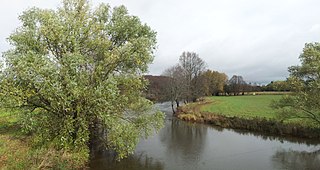
The Bighead River is a river in Grey County in southern Ontario, Canada, that flows from the Niagara Escarpment between the communities along Ontario Highway 10 of Arnott and Holland Centre in the township of Chatsworth to empty into Nottawasaga Bay, an inlet of Georgian Bay on Lake Huron, at Meaford.

Stoney Creek is a community in the city of Hamilton in the Canadian province of Ontario. It was officially a city from 1984 to 2001, when it was amalgamated with the rest of the cities of the Regional Municipality of Hamilton–Wentworth.
Devil's Punch Bowl may refer to:

Hilton Falls Conservation Area located in Campbellville, Ontario on the Niagara Escarpment is a conservation area known for its ten-metre waterfall, hiking trails and small glacial pothole. It constitutes 645 hectares and offers mountain biking as well as cross-country skiing. It is owned and operated by Conservation Halton. The Bruce Trail runs through the area.

Short Hills Provincial Park is a provincial park located in the centre of the Niagara Peninsula, bordering the city of St. Catharines and the town of Pelham in the Niagara Region in southern Ontario, Canada. It occupies an area of 660 hectares. It also borders the new vineyard sub-appellation called the Short Hills Bench.
The Hamilton Conservation Authority maintains the greenspace, trails, parks and some attractions in the Hamilton, Ontario, Canada.
Albion Falls is a 19 m (62 ft) classical/cascade waterfall flowing down the Niagara Escarpment in Red Hill Valley, in Hamilton, Ontario, Canada. With cascade falls the downpour is staggered into a series of steps causing water to "cascade". The top of the falls are located on Mountain Brow Blvd. The lower-end of the falls can be found at the south-end of King's Forest Park in lower Hamilton by following the Red Hill Creek south towards the Niagara Escarpment.

Jordan is a community located on the eastern edge of the Town of Lincoln, in the Niagara Region. Jordan is bordered by the Twenty Mile Creek and Vineland to the west, Lake Ontario to the north, St. Catharines to the east, and Pelham to the south. Lying roughly 100 km from Toronto and 65 km from Buffalo by road, Jordan is located along a major transportation corridor between Canada and the United States. In January 2014, Jordan was brought to international attention when Al-Qaeda-directed terrorists were arrested for plotting to derail a passenger train traveling from Toronto to New York on a rail-bridge crossing the Jordan Harbour.
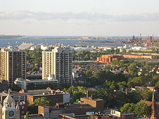
Hamilton is located on the western end of the Niagara Peninsula and wraps around the westernmost part of the Lake Ontario. Most of the city including the downtown section lies along the south shore. Situated in the geographic centre of the Golden Horseshoe, it lies roughly midway between Toronto and Buffalo. The two major physical features are Hamilton Harbour marking the northern limit of the city and the Niagara Escarpment running through the middle of the city across its entire breadth, bisecting the city into 'upper' and 'lower' parts.

Centennial Parkway is an arterial road in southeastern Hamilton, Ontario, Canada. It is best known as the western terminus of the former King's Highway 20, now maintained by the City of Hamilton. It starts off as Upper Centennial Parkway, a mountain-access road in the City right before the Canadian Pacific Railway line at the backend of Battlefield Park, and is a two-way street throughout that extends north over the Queen Elizabeth Way and ends at Beach Boulevard/Van Wagners Beach Road in front of Confederation Park.
King's Forest Park is a park in Hamilton, Ontario. It was commissioned as part of the City Beautiful movement, spearheaded in Hamilton by the Hamilton Parks Board with the leadership of Thomas McQuesten.

The Eramosa Karst is a provincially significant Earth Science Area of Natural and Scientific Interest in Ontario, Canada, located in Stoney Creek, a constituent community of the City of Hamilton, and immediately south of the Niagara Escarpment.

Spencer Gorge/Webster's Falls Conservation Area is located on the Niagara Escarpment in Dundas, Ontario, a constituent community of Hamilton, Ontario, and is owned and operated by the Hamilton Conservation Authority. It has views over Hamilton and a two major waterfalls that are accessible via a system of trails. The natural features found in the area are considered to be provincially significant. A shuttle service runs from Christie Lake Conservation Area to Spencer Gorge/Webster Falls Conservation Area, for visitors to access this conservation area on weekends and holidays.
Twelve Mile Creek is a waterway located on the Niagara Peninsula in the Regional Municipality of Niagara in Southern Ontario, Canada. Its headwaters are located in the town of Pelham, encompassing some of the most unspoiled and natural areas of Niagara area. The creek's lower reaches flow through urban areas of Thorold and St. Catharines and has been heavily altered by human activity for almost two centuries. The creek was first known as "Ashquasing" by the Mississaugas Indigenous people, the name meaning "that which lies at the end" in the Anishinaabe language.
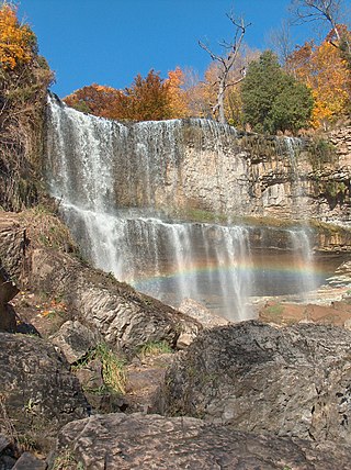
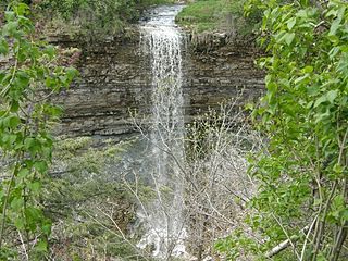
Webster's Falls, noted for its panoramas, is a 22-metre-high (72 ft) classical curtain/ plunge waterfall found in the Spencer Gorge/Webster's Falls Conservation Area in Hamilton, Ontario, Canada. The water flows down Spencer Creek. In the past the falls have been known by various names such as Dr. Hamilton's Falls, Spencer Falls, Hart Falls, Fisher Falls and Flamborough Falls.
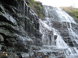
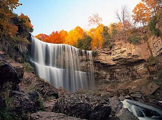
Borer's Falls is a 15-metre-high (49 ft) ribbon-style waterfall found in the Borer's Falls Conservation Area in Dundas, Hamilton, Ontario, Canada. Its source is Borer's Creek. A very picturesque waterfall featured on many Hamilton waterfall postcards over the years. Named after the Borer family who ran a sawmill for over a century. This mill was the lifeblood of the village of Rock Chapel. Also known as Rock Chapel Falls. The area is a hiker's haven and also an ice-climbing destination in the winter when the weather is cold enough to freeze the Falls.

Dundas Valley Conservation Area is located on the Niagara Escarpment in Dundas, Ontario, a constituent community of Hamilton, Ontario, and is owned and operated by the Hamilton Conservation Authority. Its 40-kilometre trail system provides a connection to the Bruce Trail. The area contains a trailhead of the Hamilton-Brantford-Cambridge Trails, Canada's first fully developed interurban multi-use trail system, which is a part of the Trans Canada Trail.

Battlefield House near King Street East and Centennial Parkway in Stoney Creek, Hamilton, Ontario, Canada is a living history museum and site of the historic Battle of Stoney Creek on June 6, 1813, which was fought during the War of 1812. It was built in 1796. The house and 15.5 acres (6.3 ha) of parkland, were the property of the Women's Wentworth Historical Society, (1899-1962), and given by this society to the Niagara Parks Commission on January 19, 1962. The park was designated a National Historic Site in 1960.


