Related Research Articles

York County is the southwesternmost county in the U.S. state of Maine, along the state of New Hampshire's eastern border. It is divided from Strafford County, New Hampshire, by the Salmon Falls River, and the connected tidal estuary—the Piscataqua River. York County was permanently established in 1639. It is the state's oldest county and one of the oldest in the United States. Several of Maine's earliest colonial settlements are found in the county. As of the 2020 census, its population was 211,972, making it Maine's second-most populous county. Its county seat is Alfred. York County is part of the Portland–South Portland, Maine Metropolitan Statistical Area.

Castine is a town in Hancock County in eastern Maine. The population was 1,320 at the 2020 census. Castine is the home of Maine Maritime Academy, a four-year institution that graduates officers and engineers for the United States Merchant Marine and marine related industries. Approximately 1000 students are enrolled. During the French colonial period, Castine was the southern tip of Acadia and served as the regional capital between 1670 and 1674.

Woolwich is a town in Sagadahoc County, Maine, United States. The population was 3,068 at the 2020 census. It is part of the Portland–South Portland–Biddeford, Maine metropolitan statistical area. Woolwich is a suburb of the city of Bath located on the opposite shore of Merrymeeting Bay.
Perkins Township is an unorganized territory in Sagadahoc County, Maine, United States. Originally incorporated as the town of Perkins, it was later abandoned, and has been uninhabited since the 1940s. The township comprises Swan Island, Little Swan Island and some tidal flats—all within the Kennebec River between the towns of Richmond and Dresden. The Swan Island Historic District comprises most of the township, with 8 buildings, 5 structures and 1,500 acres (610 ha). Some of the buildings date to the 1750s. The district was added to the National Register of Historic Places in 1995. The entire township is now protected as the Steve Powell Wildlife Management Area, and is under the jurisdiction of the Maine Department of Inland Fisheries and Wildlife. Camping, hunting, fishing, and wildlife viewing are permitted between May and October; reservations are required.
Winslow is a town and census-designated place in Kennebec County, Maine, United States, along the Kennebec River across from Waterville. The population was 7,948 at the 2020 census.

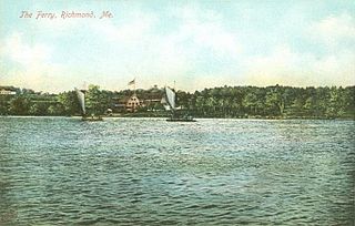
Richmond is a town in Sagadahoc County, Maine, United States. The population was 3,522 at the 2020 census. It is part of the Portland–South Portland–Biddeford, Maine metropolitan statistical area, situated at the head of Merrymeeting Bay.
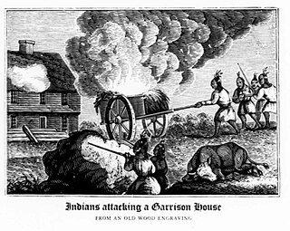
King Philip's War was an armed conflict in 1675–1676 between indigenous inhabitants of New England and New England colonists and their indigenous allies. The war is named for Metacom, the Wampanoag chief who adopted the name Philip because of the friendly relations between his father Massasoit and the Mayflower Pilgrims. The war continued in the most northern reaches of New England until the signing of the Treaty of Casco Bay on April 12, 1678.

The Province of Maine refers to any of the various English colonies established in the 17th century along the northeast coast of North America, within portions of the present-day U.S. states of Maine, New Hampshire, and Vermont, and the Canadian provinces of Quebec and New Brunswick. It existed through a series of land patents made by the kings of England during this era, and included New Somersetshire, Lygonia, and Falmouth. The province was incorporated into the Massachusetts Bay Colony during the 1650s, beginning with the formation of York County, Massachusetts, which extended from the Piscataqua River to just east of the mouth of the Presumpscot River in Casco Bay. Eventually, its territory grew to encompass nearly all of present-day Maine.

The Kennebec River is a 170-mile-long (270 km) river within the U.S. state of Maine. It rises in Moosehead Lake in west-central Maine. The East and West Outlets join at Indian Pond and the river flows southward. Harris Station Dam, the largest hydroelectric dam in the state, was constructed near that confluence. The river is joined at The Forks by its tributary the Dead River, also called the West Branch.
The District of Maine was the governmental designation for what is now the U.S. state of Maine from October 25, 1780 to March 15, 1820, when it was admitted to the Union as the 23rd state. The district was a part of the Commonwealth of Massachusetts and before American independence had been part of the British province of Massachusetts Bay.
Cornwall County was a county of the former Province of New York, established on September 5, 1665 from 25,100 square miles (65,000 km2) of land that had been granted to the Duke of York in modern Maine. As established, the grant ran all the way from the St. Lawrence River to the Atlantic Ocean, between the Kennebec and St. Croix rivers, and produced what today is most of Aroostook, Piscataquis, Washington, Hancock, Penobscot, Waldo, Knox, Lincoln, Kennebec, Somerset, and Sagadahoc Counties.

Norridgewock was the name of both an Indigenous village and a band of the Abenaki Native Americans/First Nations, an Eastern Algonquian tribe of the United States and Canada. The French of New France called the village Kennebec. The tribe occupied an area in the interior of Maine. During colonial times, this area was territory disputed between British and French colonists, and was set along the claimed western border of Acadia, the western bank of the Kennebec River.

Dummer's War (1722–1725) is also known as Father Rale's War, Lovewell's War, Greylock's War, the Three Years War, the Wabanaki-New England War, or the Fourth Anglo-Abenaki War. It was a series of battles between the New England Colonies and the Wabanaki Confederacy, who were allied with New France. The eastern theater of the war was located primarily along the border between New England and Acadia in Maine, as well as in Nova Scotia; the western theater was located in northern Massachusetts and Vermont at the border between Canada and New England. During this time, Maine and Vermont were part of Massachusetts.

The Territory of Sagadahock, also called the Sagadahoc Colony and New Castle, was an English colonial territory which included the eastern part of what was later colonial Maine and was more sparsely settled than the western region. The area included was east of the Kennebec River.
The Treaty of Casco (1678) was a treaty that brought to a close the war between the Indigenous Dawnland nations and the English settlers. There are no surviving copies of the treaty or its proceedings, so historians use a summary by Jeremy Belknap in his 1784 History of New Hampshire.
The history of the area comprising the U.S. state of Maine spans thousands of years, measured from the earliest human settlement, or approximately two hundred, measured from the advent of U.S. statehood in 1820. The present article will concentrate on the period of European contact and after.

Colonial Pemaquid State Historic Site is a publicly owned historic property operated by the state of Maine near Pemaquid Beach in Bristol, Maine. The site includes the reconstructed Fort William Henry, archaeological remains of 17th- and 18th-century village buildings and fortifications, and a museum with artifacts found on the site including musket balls, coins, pottery, and early hardware.
The First Abenaki War was fought along the New England/Acadia border primarily in present-day Maine. Richard Waldron and Charles Frost led the forces in the northern region, while Jean-Vincent d'Abbadie de Saint-Castin worked with the tribes that would make up the Wabanaki Confederacy. The natives engaged in annual campaigns against the English settlements in 1675, 1676, and 1677. Waldron sent forces so far north that he attacked the Mi'kmaq in Acadia.

The Maine Kennebec Bridge is a bridge that crosses the Kennebec River between Richmond and Dresden, Maine. It was built in 2014 to replace the 84-year-old Richmond-Dresden Bridge, a swing bridge that had previously acted as the only method of crossing the river in that area. The Maine Kennebec Bridge is significantly taller than the old bridge, and was designed for at least 75 feet of clearance during high tide, allowing boats to pass without the need for a swing-span design.
References
- Williamson, History of Maine
Coordinates: 44°06′14.3″N69°23′10.8″W / 44.103972°N 69.386333°W
| | This Massachusetts state location article is a stub. You can help Wikipedia by expanding it. |
| | This article relating to the history of the United States is a stub. You can help Wikipedia by expanding it. |