Related Research Articles

Enterprise resource planning (ERP) is the integrated management of main business processes, often in real time and mediated by software and technology. ERP is usually referred to as a category of business management software—typically a suite of integrated applications—that an organization can use to collect, store, manage and interpret data from many business activities. ERP systems can be local-based or cloud-based. Cloud-based applications have grown in recent years due to the increased efficiencies arising from information being readily available from any location with Internet access.

In urban planning, zoning is a method in which a municipality or other tier of government divides land into "zones", each of which has a set of regulations for new development that differs from other zones. Zones may be defined for a single use, they may combine several compatible activities by use, or in the case of form-based zoning, the differing regulations may govern the density, size and shape of allowed buildings whatever their use. The planning rules for each zone determine whether planning permission for a given development may be granted. Zoning may specify a variety of outright and conditional uses of land. It may indicate the size and dimensions of lots that land may be subdivided into, or the form and scale of buildings. These guidelines are set in order to guide urban growth and development.

Postal codes used in the United Kingdom, British Overseas Territories and Crown dependencies are known as postcodes. They are alphanumeric and were adopted nationally between 11 October 1959 and 1974, having been devised by the General Post Office.
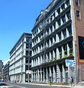
SoHo, often referred to as SoHo, is a neighborhood in Lower Manhattan, New York City. Since the 1970s, the neighborhood has been the location of many artists' lofts and art galleries, and has also been known for its variety of shops ranging from trendy upscale boutiques to national and international chain store locations. The area's history is an archetypal example of inner-city regeneration and gentrification, encompassing socioeconomic, cultural, political, and architectural developments.

A neighbourhood or neighborhood is a geographically localized community within a larger city, town, suburb or rural area, sometimes consisting of a single street and the buildings lining it. Neighbourhoods are often social communities with considerable face-to-face interaction among members. Researchers have not agreed on an exact definition, but the following may serve as a starting point: "Neighbourhood is generally defined spatially as a specific geographic area and functionally as a set of social networks. Neighbourhoods, then, are the spatial units in which face-to-face social interactions occur—the personal settings and situations where residents seek to realise common values, socialise youth, and maintain effective social control."

In general, a rural area or a countryside is a geographic area that is located outside towns and cities. Typical rural areas have a low population density and small settlements. Agricultural areas and areas with forestry are typically described as rural, as well as other areas lacking substantial development. Different countries have varying definitions of rural for statistical and administrative purposes.
Land use planning or Land-use regulation is the process of regulating the use of land by a central authority. Usually, this is done to promote more desirable social and environmental outcomes as well as a more efficient use of resources. More specifically, the goals of modern land use planning often include environmental conservation, restraint of urban sprawl, minimization of transport costs, prevention of land use conflicts, and a reduction in exposure to pollutants. In the pursuit of these goals, planners assume that regulating the use of land will change the patterns of human behavior, and that these changes are beneficial. The first assumption, that regulating land use changes the patterns of human behavior is widely accepted. However, the second assumption - that these changes are beneficial - is contested, and depends on the location and regulations being discussed.
A telephone numbering plan is a type of numbering scheme used in telecommunication to assign telephone numbers to subscriber telephones or other telephony endpoints. Telephone numbers are the addresses of participants in a telephone network, reachable by a system of destination code routing. Telephone numbering plans are defined in each of the administrative regions of the public switched telephone network (PSTN) and in private telephone networks.

Redevelopment is any new construction on a site that has pre-existing uses. It represents a process of land development uses to revitalize the physical, economic and social fabric of urban space.
Town and country planning in the United Kingdom is the part of English land law which concerns land use planning. Its goal is to ensure sustainable economic development and a better environment. Each country of the United Kingdom has its own planning system that is responsible for town and country planning, which outside of England is devolved to the Northern Ireland Assembly, the Scottish Parliament and the Senedd.

A town centre is the commercial or geographical centre or core area of a town. Town centres are traditionally associated with shopping or retail. They are also the centre of communications with major public transport hubs such as train or bus stations. Public buildings including town halls, museums and libraries are often found in town centres.
Points per game, often abbreviated PPG, is the average number of points scored by a player per game played in a sport, over the course of a series of games, a whole season, or a career. It is calculated by dividing the total number of points by number of games. The terminology is often used in basketball and ice hockey. For description of sports points see points for ice hockey or points for basketball. In games divided into fixed time periods, especially those in which a player may exit and re-enter the game multiple or an unlimited number of times, a player may receive the same credit for participation in a game regardless of how long they were actually on the field or court. For this reason, the points-per-game statistic may understate the contribution of players who are highly effective but used only in certain specific "pinch" or "clutch" scenarios, such that a points-per-unit-time figure may better represent their effectiveness within the context in which a coach or manager plays them. Although the points-per-game statistic has the advantage of factoring in the breadth of scenarios in which the player is effective, in that a player effective in many different scenarios will play more minutes per game and therefore contribute more to the team's overall performance, it still fails to distinguish between an ineffective player, an effective "pinch"/"clutch" offensive player, and a player assuming a primarily defensive role in a position whose title does not necessarily make the nature of their role obvious.

Mixed use is a type of urban development, urban design, urban planning and/or a zoning classification that blends multiple uses, such as residential, commercial, cultural, institutional, or entertainment, into one space, where those functions are to some degree physically and functionally integrated, and that provides pedestrian connections. Mixed-use development may be applied to a single building, a block or neighborhood, or in zoning policy across an entire city or other administrative unit. These projects may be completed by a private developer, (quasi-)governmental agency, or a combination thereof. A mixed-use development may be a new construction, reuse of an existing building or brownfield site, or a combination.
The streets and highways of Washington, D.C., form the core of the surface transportation infrastructure in Washington, D.C., the federal capital of the United States. Given that it is a planned city, the city's streets follow a distinctive layout and addressing scheme. There are 1,500 miles (2,400 km) of public roads in the city, of which 1,392 miles (2,240 km) are owned and maintained by city government.
Parents Involved in Community Schools v. Seattle School District No. 1, 551 U.S. 701 (2007), also known as the PICS case, is a United States Supreme Court case which found it unconstitutional for a school district to use race as a factor in assigning students to schools in order to bring its racial composition in line with the composition of the district as a whole, unless it was remedying a prior history of de jure segregation. Chief Justice Roberts wrote in his plurality opinion that "The way to stop discrimination on the basis of race is to stop discriminating on the basis of race."

Lands administrative divisions of Australia are the cadastral divisions of Australia for the purposes of identification of land to ensure security of land ownership. Most states term these divisions as counties, parishes, hundreds, and other terms. The eastern states of Queensland, New South Wales, Victoria, and Tasmania were divided into counties and parishes in the 19th century, although the Tasmanian counties were renamed land districts in the 20th century. Parts of South Australia (south-east) and Western Australia (south-west) were similarly divided into counties, and there were also five counties in a small part of the Northern Territory. However South Australia has subdivisions of hundreds instead of parishes, along with the Northern Territory, which was part of South Australia when the hundreds were proclaimed. There were also formerly hundreds in Tasmania. There have been at least 600 counties, 544 hundreds and at least 15,692 parishes in Australia, but there are none of these units for most of the sparsely inhabited central and western parts of the country.

A pandal in India and neighbouring countries, is a fabricated structure, either temporary or permanent, that is used at many places such as either outside a building or in an open area such as along a public road or in front of a house. This canopy or big tent is often used in a religious or other events that gathers people together, such as a wedding, fair, exhibition or festival.
Buikslotermeer is a neighborhood and a polder of Amsterdam, Netherlands. The Buikslotermeer is a reclaimed lake, now largely located within the city of Amsterdam-Noord. Nowadays, the name 'Buikslotermeer' is used to refer to the entire Buikslotermeerpolder of the similarly named neighborhood, located in the south-east of the polder.

Motueka Aerodrome is the airport serving Motueka, New Zealand, and is owned and managed by Tasman District Council.
The 2014 Hart District Council election took place on 22 May 2014 to elect members of Hart District Council in England. This was on the same day as other local elections, as well as the 2014 European Parliament elections. The election saw new boundaries, the first revision since 2002.
References
- ↑ "A Guide to Using the District Plan" (PDF). Auckland Council District Plan Operative North Shore Section 2002.
| | This government of New Zealand–related article is a stub. You can help Wikipedia by expanding it. |
| | This article relating to law in New Zealand is a stub. You can help Wikipedia by expanding it. |