
This is a list of properties and districts listed on the National Register of Historic Places in Rhode Island. As of May 29, 2015, there are more than 750 listed sites in Rhode Island. All 5 of the counties in Rhode Island have listings on the National Register.

The Eleazer Arnold House is a historic house built for Eleazer Arnold in about 1693, and located at 487 Great Road, Lincoln, Rhode Island in the Great Road Historic District. It is now a National Historic Landmark owned by Historic New England, and open to the public on weekends.
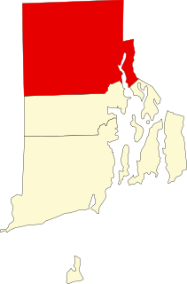
This is a list of the National Register of Historic Places listings in Providence County, Rhode Island.

Carolina is a village that straddles the border of the towns of Charlestown and Richmond on the Pawcatuck River in Washington County, Rhode Island. Rhode Island Route 112 passes through the village. Carolina is identified as a census-designated place for reporting of data from the 2010 census.

This is a list of the National Register of Historic Places listings in Providence, Rhode Island.
Clayville Historic District is an 81-acre (33 ha) historic district in Foster and Scituate, Rhode Island. The district encompasses the heart of the village of Clayville, a small 19th-century mill village. It is centered on the junction of Plainfield Pike, Field Hill Road, and Victory Highway near the Clayville Mill pond, and is roughly bisected by the town line between Foster and Scituate. The mill pond is impounded by a c. 1847 dam, which powered mills whose ruins and waterways lie downstream. The village is mainly residential, with vernacular 19th-century construction predominating. Notable buildings include the Clayville Christian Union Church, built 1867-71 with Greek Revival styling, and the c. 1845 Clayville Schoolhouse.
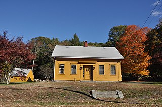
The District 6 Schoolhouse is an historic school building located at 347 Willett Avenue in East Providence, Rhode Island. It is a single-story wood frame structure, with a pair of entry doors and a low-pitch gable roof. The interior has been extensively altered to meet its modern usage as a meeting space. The school was built between 1864 and 1874, and is the oldest surviving school building in the city.
The Moosup Valley Historic District is a rural, agricultural historic district in western Foster, Rhode Island. The focal center of the area is a small village where Moosup Valley Road crosses the Moosup River, and where the Moosup Valley Christian Church is located. The largest concentration of buildings in the district lie along a roughly one-mile stretch of Moosup Valley Road west of Rhode Island Route 14, with properties extending along some of the winding roads that extend from that road. The district encompasses most of the headwaters of the Moosup River. The major public buildings are the church, a vernacular Greek Revival structure built in 1864-65, and the Grange hall, built in 1926. There is also a one-room schoolhouse which was built in 1811, and later used as a library and community center.

The Pullen Corner School is an historic schoolhouse at the corner of Angell and Whipple Roads in Lincoln, Rhode Island. It is a small wood frame structure with a gable roof, set on a granite foundation. It is a single bay wide and two deep, with the interior divided between a small vestibule area and the single classroom. The property also includes a woodshed and privy. The schoolhouse was built c. 1840, and was one of the first schoolhouses built by the town.

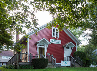
The Brick Schoolhouse is a historic colonial meeting house and school at 24 Meeting Street in the College Hill neighborhood of Providence, Rhode Island.

The Historic Village of the Narragansetts in Charlestown is an historic district in Charlestown, Rhode Island encompassing what were for nearly two centuries the reservation lands of the Narragansett people. The district covers 5,600 acres (23 km2) and is bounded by Route 112 on the east, U.S. Route 1 on the south, King's Factory Road on the west, and Route 91 on the north. These lands served as the Narragansett reservation between 1709 and 1880, when the tribe sold the land to the state and was formally detribalized. Because of this long period of Native occupation, the area is archaeologically important, containing both historic and prehistoric artifacts. The Narragansetts have since received federal recognition.

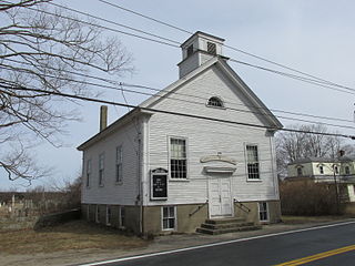
The Shannock Historic District is a historic mill village located along the Pawcatuck River in the towns of Richmond and Charlestown, Rhode Island. The postal code for Shannock is 02875. The village extends along Old Shannock Road, Railroad Street, and Shannock Village Road between two crossings of the Pawcatuck, which forms the border between the two towns. It lies mainly in Richmond, but extends along the road running southwest and southeast from the two crossings. Two mill complexes are the visual focal points of the village: the Carmichael plant on the west, and the Columbia Narrow Fabrics Company complex near the village center. The buildings in the village are predominantly residential worker housing set close to the road, which were built in the second half of the 19th century. There are two imposing Greek Revival houses, both built c. 1850, and one Late Victorian house, all of which belonged to mill owners. The area was listed on the National Register of Historic Places in 1983.
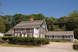
The Joseph Stanton House is a historic house at 5153 Old Post Road in Charlestown, Rhode Island. The main house is a 2-½ story wood frame structure built some time before 1739 by Joseph Stanton II, and it is where his son Joseph Stanton, Jr. was born. The exterior has a relatively plain finish except for its front door surround, a 19th-century Greek Revival alteration with sidelight windows and pilasters supporting an entablature. A 1930s addition to the rear of the house provides additional space for modern restaurant facilities. The house belonged to Stanton, Jr. until 1811, one of Rhode Island's first United States Senators. He sold it to Edward Wilcox who began operating a tavern on the premises. An obelisk stands nearby memorializing Stanton.
The Usquepaug Road Historic District is a historic district near the village of Usquepaug in South Kingstown, Rhode Island. It consists of a collection of properties, mostly on the south side of Usequepaug Road between the Usquepaug Cemetery and Dugway Bridge Road. Although the area began as a rural, agricultural area, it developed into a modest rural village, with a church, school, and cluster of vernacular rural houses. The schoolhouse was destroyed in the New England Hurricane of 1938.

The Read School is a historic schoolhouse at 1670 Flat River Road in Coventry, Rhode Island, USA. Built c. 1831, it is one of the oldest, and the best-preserved, of Coventry's 19th-century schoolhouses. It is a rectangular wood-frame structure measuring 18 feet (5.5 m) by 24 feet (7.3 m), with a gable roof. The south side, its main facade, has a pair of doors under a ten-light transom window and a shallow entry cover. Above this is a round window, a detail echoed on the north side. It served the town as a school until 1951, and was then used for storage. It is now leased by the town to the Coventry Historical Society, who conduct tours and hold meetings there.
The Union Church is an historic church and local history museum owned by the Portsmouth Historical Society at 870 East Main Road in Portsmouth, Rhode Island. One exhibit room is dedicated to Julia Ward Howe and includes a collection of furniture from her summer home in Portsmouth and a display about her life.

The South Main Street Historic District is a historic district in Coventry, Rhode Island. It extends along South Main Street from its crossing of the South Branch of the Pawtuxet River in the north, to just below Wood Street in the south, and includes a few properties on immediately adjacent streets. The area is almost entire residential, and was developed in the 19th century, providing housing for middle-class workers not directly affiliated with the mills that lined the river. About half the houses were built before 1850, and exhibit either Federal or Greek Revival styling, while most of the remaining houses were built before 1920. The principal non-residential structures are a VFW hall, which began as a mid-19th century residential structure associated with Rhode Island's prominent Whipple family, the Stillwater Company mill at the northern end of the district (1914), and the three-room Cady Street Schoolhouse (1844).

The Charlestown Main Street Historic District encompasses the historic heart of Charlestown, New Hampshire. It is located along Main Street, roughly between Lower Landing Road and Bridge Street, and encapsulates more than two hundred years of the town's history. The district was listed on the National Register of Historic Places in 1987.
This is a list of Registered Historic Places in Charlestown, Rhode Island.
This is a list of Registered Historic Places in Cranston, Rhode Island.


