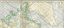
Former district of the Canadian Northwest Territories
This article is about the Canadian regional district. For the territory of the United States that existed between 1784 and 1788, see State of Franklin. For other uses, see Franklin (disambiguation).
English navigators Martin Frobisher and Henry Hudson were the first Europeans known to have visited the area (although Viking sailors, coming from Greenland, may have made occasional landings and hunting treks on Baffin Island in the 11th and 12th centuries). The area was transferred from British colonial authority to the Dominion of Canada in 1894 and named after Sir John Franklin in the following year; however, the northernmost islands were claimed by Norway until the year 1930.
Along with the District of Keewatin and the District of Mackenzie, it was one of the three districts of the old Northwest Territories before the formation of Nunavut in 1999, at which point the district ceased to exist, although as an administrative district of the NWT it had ceased to function several years prior to the splitting off of Nunavut. The area of the former District of Franklin was divided between the remaining portion of the Northwest Territories and Nunavut. In the process, Victoria Island was divided with approximately two-thirds of its area falling in Nunavut, and several other islands were also divided between the two territories.
Balkwill, H. R. Geology of Amund Ringnes, Cornwall, and Haig-Thomas Islands, District of Franklin. Ottawa, Ont., Canada: Geological Survey of Canada, 1983. ISBN0-660-10855-0
Balkwill, H. R., W. S. Hopkins, and J. H. Wall. Geology of Lougheed Island and Nearby Small Islands, District of Franklin (Parts of 69C, 79D). Ottawa, Canada: Minister of Supply and Services Canada, 1982. ISBN0-660-10856-9
Geological Survey of Canada, R. L. Christie, H. P. Trettin, and U. Mayr. Lady Franklin Bay, District of Franklin, Northwest Territories. Open file (Geological Survey of Canada), 2136. 1984.
Dyke, Arthur S., John T. Andrews, and Gifford H. Miller. Quaternary Geology of Cumberland Peninsula, Baffin Island, District of Franklin. Ottawa, Canada: Geological Survey of Canada, 1982. ISBN0-660-11182-9
Geological Survey of Canada, A. F. Embry, H. P. Trettin, and U. Mayr. Tanquary Fiord, District of Franklin, Northwest Territories. Open file (Geological Survey of Canada), 2135. 1988.
Related Research Articles
Baffin Island, in the Canadian territory of Nunavut, is the largest island in Canada and the fifth-largest island in the world. Its area is 507,451 km2 (195,928 sq mi) with a population density of 0.03/km²; the population was 13,039 according to the 2021 Canadian census; and it is located at 68°N70°W. It also contains the city of Iqaluit, which is the capital of Nunavut.
Victoria Island is a large island in the Arctic Archipelago that straddles the boundary between Nunavut and the Northwest Territories of Canada. It is the eighth-largest island in the world, and at 217,291 km2 (83,897 sq mi) in area, it is Canada's second-largest island. It is nearly double the size of Newfoundland (111,390 km2 [43,010 sq mi]), and is slightly larger than the island of Great Britain (209,331 km2 [80,823 sq mi]) but smaller than Honshu (225,800 km2 [87,200 sq mi]). The western third of the island lies in the Inuvik Region of the Northwest Territories; the remainder is part of Nunavut's Kitikmeot Region. The population of 2,168 is divided among two settlements, the larger of which is in Nunavut and the other of which is in the Northwest Territories.
Frobisher Bay is an inlet of the Davis Strait in the Qikiqtaaluk Region of Nunavut, Canada. It is located in the southeastern corner of Baffin Island. Its length is about 230 km (140 mi) and its width varies from about 40 km (25 mi) at its outlet into the Labrador Sea to roughly 20 km (12 mi) towards its inner end.
Melville Island is an uninhabited member of the Queen Elizabeth Islands of the Arctic Archipelago. With an area of 42,149 km2 (16,274 sq mi), It is the 33rd largest island in the world and Canada's eighth largest island.
Somerset Island is a large, uninhabited island of the Arctic Archipelago, that is part of the Canadian territory of Nunavut. The island is separated from Cornwallis Island and Devon Island to the north by the Parry Channel, from Baffin Island to the east by Prince Regent Inlet, from the Boothia Peninsula to the south by Bellot Strait, and from Prince of Wales Island to the west by Peel Sound. It has an area of 24,786 km2 (9,570 sq mi), making it the 46th largest island in the world and Canada's twelfth largest island.
The vastness of Canada's Northwest Territories meant that for much of its history it was divided into several districts for ease of administration. The number and size of these territorial districts varied as other provinces and territories of Canada were created and expanded. The districts of the Northwest Territories were abolished in 1999 with the creation of the Nunavut territory and the contraction of the Northwest Territories to its current size.
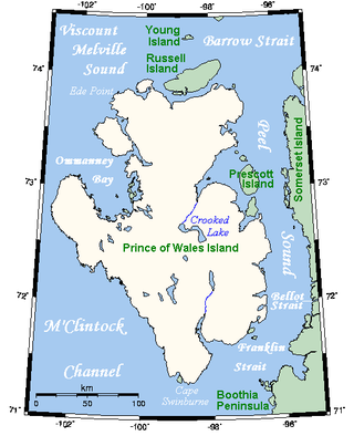
Prince of Wales Island is an Arctic island in Nunavut, Canada. One of the larger members of the Arctic Archipelago, it lies between Victoria Island and Somerset Island and is south of the Queen Elizabeth Islands.
Amund Ringnes Island is an uninhabited island and one of the Sverdrup Islands and Queen Elizabeth Islands in the Qikiqtaaluk Region, Nunavut, Canada. It is located in the Arctic Ocean, between 78 and 79 degrees of latitude. It lies east of Ellef Ringnes Island, west of Axel Heiberg Island. Hassel Sound separates Amund Ringnes Island from Ellef Ringnes Island. Hendriksen Strait is to the south, as is Cornwall Island. Norwegian Bay is to the east, as is Haig-Thomas Island. To the north lies Peary Channel.
Bylot Island lies off the northern end of Baffin Island in Nunavut Territory, Canada. Eclipse Sound to the southeast and Navy Board Inlet to the southwest separate it from Baffin Island. Parry Channel lies to its northwest. At 11,067 km2 (4,273 sq mi) it is ranked 71st largest island in the world and Canada's 17th largest island. The island measures 180 km (110 mi) east to west and 110 km (68 mi) north to south and is one of the largest uninhabited islands in the world. While there are no permanent settlements on this Canadian Arctic island, Inuit from Pond Inlet and elsewhere regularly travel to Bylot Island. An Inuit seasonal hunting camp is located southwest of Cape Graham Moore.
The District of Keewatin was a territory of Canada and later an administrative district of the Northwest Territories. It was created in 1876 by the Keewatin Act, and originally it covered a large area west of Hudson Bay. In 1905, it became a part of the Northwest Territories and in 1912, its southern parts were adjoined to the provinces of Manitoba and Ontario, leaving the remainder, now called the Keewatin Region, with a population of a few thousand people. On April 1, 1999, the Keewatin Region was formally dissolved, as Nunavut was created from eastern parts of the Northwest Territories, including all of Keewatin.
Melville Peninsula is a large peninsula in the Canadian Arctic north of Hudson Bay. To the east is Foxe Basin and to the west the Gulf of Boothia. To the north the Fury and Hecla Strait separates it from Baffin Island. To the south Repulse Bay and Frozen Strait separate it from Southampton Island at the north end of Hudson Bay. On the southwest it is connected to the mainland by the Rae Isthmus, named after the Arctic explorer John Rae.
Boothia Peninsula is a large peninsula in Nunavut's northern Canadian Arctic, south of Somerset Island. The northern part, Murchison Promontory, is the northernmost point of mainland Canada.
Foxe Basin is a shallow oceanic basin north of Hudson Bay, in Nunavut, Canada, located between Baffin Island and the Melville Peninsula. For most of the year, it is blocked by sea ice and drift ice made up of multiple ice floes.
Auyuittuq National Park is a national park located on Baffin Island's Cumberland Peninsula, in the Qikiqtaaluk Region of Nunavut, the largest political subdivision of Canada. The park was initially known as Baffin Island National Park when it was established in 1972, but the name was changed in 1976 to its current name to better reflect the region and its history. It features many terrains of Arctic wilderness, such as fjords, glaciers, and ice fields. Although Auyuittuq was established in 1972 as a national park reserve, it was upgraded to a full national park in 2000.
Cumberland Peninsula is a peninsula in the southeastern part of Baffin Island in Nunavut, Canada. It is located between 64°56' and 67°57' north latitude, and 61°56' to 68° west longitude. The Arctic Circle crosses the peninsula, with the Labrador Sea to the southeast, and the Davis Strait to the east, which lies between the peninsula and Greenland. The Cumberland Sound lies to the southwest, separating the Cumberland Peninsula from the Hall Peninsula, which is also part of Baffin Island.
Fury and Hecla Strait is a narrow Arctic seawater channel located in the Qikiqtaaluk Region of Nunavut, Canada.
King Christian Island is an uninhabited member of the Arctic Archipelago in the Sverdrup Islands, a part of the Queen Elizabeth Islands archipelago, in the Qikiqtaaluk Region of Nunavut, Canada. It lies in the Arctic Ocean, 13.5 km (8.4 mi) from the southwestern coast of Ellef Ringnes Island, separated by the Danish Strait.
Prince Alfred Bay is a waterway in Qikiqtaaluk Region, Nunavut, Canada. It lies off the western coast of Devon Island, forming a border of the Grinnell Peninsula, in the eastern high Arctic. Like Pioneer Bay to the south, it is an arm of Wellington Channel.
The Devon Island Formation is a geologic formation in the Canadian Arctic. It preserves fossils dating back to the late Silurian and Devonian periods.
The Eurekan orogeny was a Phanerozoic mountain building event that affected the eastern portion of the Arctic Archipelago and, to a lesser extent, northern Greenland. Deformation initiated in the Late Cretaceous, during which time the Sverdrup Basin began to fragment and fold in response to the counterclockwise rotation of Greenland, caused by seafloor spreading in the Canadian Arctic Rift System. Isostatic uplift was most pronounced in the Grantland Mountains and Victoria and Albert Mountains on Ellesmere Island and in the Princess Margaret Range on Axel Heiberg Island, as evidenced by the current physiography. Compression in a broad zone on Ellesmere Island resulted in the formation of the Eurekan Fold Belt.
This page is based on this Wikipedia article Text is available under the CC BY-SA 4.0 license; additional terms may apply. Images, videos and audio are available under their respective licenses.