
Càrn Eige, sometimes spelt Càrn Eighe, is a mountain in the north of Scotland. At an elevation of 1,183 metres (3,881 ft) above sea level, it is the highest mountain in northern Scotland, the twelfth-highest summit above sea level in the British Isles, and, in terms of relative height, it is the second-tallest mountain in the British Isles after Ben Nevis. The highpoint of the historic county of Ross and Cromarty, it is the twin summit of the massif, being mirrored by the 1,181-metre (3,875 ft) Mam Sodhail, to the south on the same ridge.
Dudley Coutts Marjoribanks, 1st Baron Tweedmouth, also known as the Laird of Guisachan and Glenaffric,, was a Scottish businessman and a Liberal politician who sat in the House of Commons from 1853 until 1880, when he was elevated to the peerage as Baron Tweedmouth.
The Northwest Highlands are located in the northern third of Scotland that is separated from the Grampian Mountains by the Great Glen. The region comprises Wester Ross, Assynt, Sutherland and part of Caithness. The Caledonian Canal, which extends from Loch Linnhe in the south-west, via Loch Ness to the Moray Firth in the north-east splits this area from the rest of the country. The city of Inverness and the town of Fort William serve as gateways to the region from the south.

Sgùrr nan Ceathreamhnan is a Scottish mountain that is situated in the remote and lonely mountainous country between Glen Affric and Glen Elchaig, some 30 kilometres east of Kyle of Lochalsh in the Highland region. With a height of 1151 metres (3776 feet) it is ranked as the third highest mountain north of the Great Glen and is regarded as one of the finest hills in the whole of the United Kingdom. It is different from the other neighbouring Affric Hills, characterised by sweeping flanks and long slender ridges, which emerge from the central summit crest in the manner of the spokes of a wheel.

A' Chràlaig is a mountain in the Scottish Highlands, north of Loch Cluanie and south of Glen Affric. It is the highest peak along Glen Shiel and can be easily climbed from the Cluanie Inn on the A87. The eastern slopes of the mountain, are owned by the Forestry Commission and are part of the Kintail National Scenic Area.

Ciste Dhubh is a mountain in the Scottish Highlands between Glen Shiel and Glen Affric. It is far from any centres of population, with Kyle of Lochalsh being almost 30 kilometres (19 mi) away to the west-northwest.
Glen Strathfarrar is a glen in the Highland region of Scotland, near Loch Ness. Glen Strathfarrar is named for the River Farrar, which runs through the glen, and which derives from the Pictish var, and was known to the Romans as Varrar. The full name is a curious 'Gaelicisation' of the Gaelic: as a strath is an elongated glen, a title of 'Glen Strath' is tautological, and it is therefore likely that an English-only speaker, ignorant of the meaning of 'Strath' when transcribing the map of the location, recorded that this was the 'Glen of Strathfarrar'.

Glenmoriston or Glen Moriston is a river glen in the Scottish Highlands, that runs from Loch Ness, at the village of Invermoriston, westwards to Loch Cluanie, where it meets with Glen Shiel. The A887 and A87 roads pass through Glenmoriston.

Ben Tee is a Scottish mountain situated in the Lochaber area of the Highland council area, some 15 kilometres north of Spean Bridge. It is rated as one of the best of Scotland’s smaller mountains with Hamish Brown saying:

Garbh Uisge is a river of approximately 7 km in the Trossachs of Scotland just north-west Callander. It is the outflow of Loch Lubnaig and joins with Eas Gobhain west of Callander to form the River Teith. The name of the river, Garbh Uisge, is Gaelic for "Rough Water", reflecting the nature of the river. The river is often informally called the River Leny due to the Falls of Leny, where the river crosses the Highland Boundary Fault, and because it flows through the Pass of Leny.

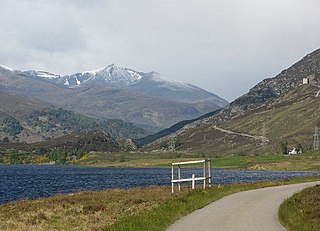
Glen Cannich is a long glen in the Northwest Highlands of Scotland and through which runs the River Cannich. Emerging from the reservoir of Loch Mullardoch, the river flows east to merge with the River Affric at the village of Cannich, their combined waters forming the River Glass.

Avich Falls near Dalavich in Argyll and Bute is a waterfall in Scotland.
Dog Falls, Glen Roy is a waterfall of Scotland.

Victoria Falls is a waterfall on the southern side of Loch Maree in Wester Ross in the north-west of Scotland. It is on the Abhainn Garbhaig, a short river that flows from Loch Garbhaig to Loch Maree. The falls are within Slattadale Forest, owned by the Forestry Commission.

Plodda Falls is a waterfall, situated 5 km south-west of the village of Tomich, near Glen Affric, in the Highlands of Scotland. The falls are 46 m high, and are on the Allt na Bodachan, near where it flows into the Abhainn Deabhag, which in turn joins with the River Affric to form the River Glass.

Glenurquhart or Glen Urquhart is a glen running to the west of the village of Drumnadrochit in the Highland council area of Scotland.
Dog Falls is the name of several waterfalls:
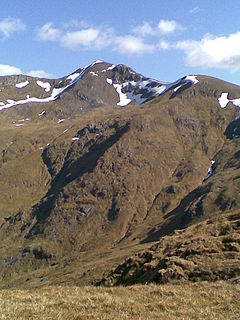
Mullach Fraoch-choire is a 1,102-metre (3,615 ft) mountain – a Munro – in the Northwest Highlands of Scotland on a ridge extending north for 8 kilometres (5.0 mi) between Loch Cluanie in Glenmoriston and upper Glen Affric. It is within the Glen Affric National Scenic Area and Glen Affric National Nature Reserve.


