
Douglas Head (Manx: Kione Ghoolish) is a rocky point on the Isle of Man overlooking Douglas Bay and harbour. Views extend to include Snaefell Mountain and Laxey.
Douglas Head (Manx: Kione Ghoolish) is a rocky point on the Isle of Man overlooking Douglas Bay and harbour. Views extend to include Snaefell Mountain and Laxey.

Until 1870, the headland was owned by The Nunnery Estate when Sir John Goldie-Taubman gave part of it to 'the people of Douglas' by donating it to Douglas Town Council. The headland was a popular area during the Victorian tourism period with access available via South Quay or by using the three steam ferries of Douglas Harbour Ferry Service.


Douglas Head is home to three memorials:

St Mary's Isle is a partially submerged reef in Douglas Bay on the Isle of Man. Prior to 1832 the rock was the property of the Quane family until John Quane, Attorney General of the Isle of Man, presented the rock to Sir William Hillary, in his capacity as President of the Isle of Man District of the Royal National Lifeboat Institution to build the Tower of Refuge. Since then the custody of St Mary's Isle has been held by each president of the local lifeboat association.

Douglas is the capital city and largest settlement of the Isle of Man, with a population of 26,677 (2021) and an area of 4.1 square miles (10.5 km2). It is located at the mouth of the River Douglas, and on a sweeping bay of two miles. The River Douglas forms part of the city's harbour and main commercial port.

Castletown is a town in the Isle of Man, geographically within the historical parish of Malew but administered separately. Lying at the south of the island, it was the Manx capital until 1869. The centre of town is dominated by Castle Rushen, a well-preserved medieval castle, originally built for a Viking king.

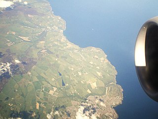
Laxey is a village on the east coast of the Isle of Man. Its name derives from the Old Norse Laxa meaning 'Salmon River'. Its key distinguishing features are its three working vintage railways and the largest working waterwheel in the world. It is also the location of King Orry's Grave.
Onchan is a large village in the parish of Onchan on the Isle of Man. It is at the north end of Douglas Bay. Administratively a district, it has the second largest population of settlements on the island, after Douglas, with which it forms a conurbation.

Peel is a seaside town and small fishing port in the Isle of Man, in the historic parish of German but administered separately. Peel is the third largest town in the Island after Douglas and Ramsey but the fourth largest settlement, as Onchan has the second largest population but is classified as a village.

Port Erin is a seaside village in the south-west of the Isle of Man, in the historic parish of Rushen. It was previously a seaside resort before the decline of the tourist trade. Administratively it is designated as a village district, with its own board of commissioners. The district covers around 1 square mile, and is adjacent to: Port St Mary to the south-east; the main part of Arbory and Rushen parish district to the north and east; the sea to the west; and an exclave of Arbory and Rushen parish district to the south. Following recent residential expansion, the settlement is now contiguous with that of Port St Mary, and on 18 July 2018 Tynwald authorised a public enquiry into the proposed expansion of the district boundary to include some of this expansion.
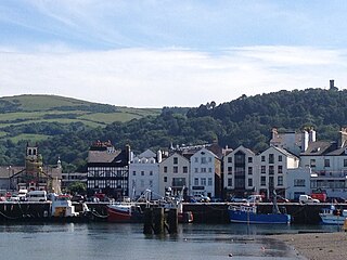
Ramsey is a coastal town in the north of the Isle of Man. It is the second largest town on the Island after Douglas. Its population is 8,288 according to the 2021 Census. It has one of the biggest harbours on the Island, and has a prominent derelict pier, called the Queen's Pier. It was formerly one of the main points of communication with Scotland. Ramsey has also been a route for several invasions by the Vikings and Scots.

Ardrossan is a town on the North Ayrshire coast in southwestern Scotland. The town has a population of 10,670 and forms part of a conurbation with Saltcoats and Stevenston known as the 'Three Towns'. Ardrossan is located on the east shore of the Firth of Clyde.
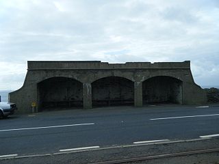
Port Soderick Railway Station is the first station on the Port Erin line of the Isle of Man Railway and is located near the settlement of the same name on the Isle of Man. It forms part of the sole remaining section of the railway which once served a 46-mile network across the island. The station was built primarily to serve the popular coastal resort which is a short walk from the station via one of the Manx National Glens. Although largely derelict today, this resort was once a hugely popular destination for tourists
The Foxdale Railway was a 3 ft narrow gauge branch line which ran from St. John's to Foxdale in the Isle of Man. The line ran 2+1⁄4 miles (3.6 km) from an end-on junction with the Manx Northern Railway west of St. John's, then passed to the north of the Isle of Man Railway station before curving south and crossing the IMR's line from Douglas via an overbridge to the east of the station. The line had a fairly constant incline through Waterfall(s) Halt, the only intermediate station, to the terminus in Upper Foxdale. The tracks extended beyond Foxdale into the mine workings area.

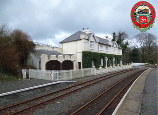
Ramsey Station was a station on the Manx Northern Railway, later owned and operated by the Isle of Man Railway; it served the town of Ramsey in the Isle of Man, and was the terminus of a line that ran between St. John's and this station, which was the railway's headquarters. The station opened to traffic on 23 September 1879.

Douglas Southern Electric Tramway was a standard gauge tramway between the top of Douglas Head on the Isle of Man and the nearby resort of Port Soderick.

Douglas Head Amphitheatre is a structure on the promontory of Douglas Head in the Isle of Man.
Howstrake Camp halt is a stop on the Manx Electric Railway on the Isle of Man located at the line's first summit on the climb from the terminus, before descending into the nearby valley.
Port Jack Halt is the name of the first official stopping place on the Manx Electric Railway on the Isle of Man and is situated a short distance from the terminus.

Quarterbridge is situated soon after the 1 mile-marker measured from the TT Grandstand, part of the Snaefell Mountain Course used for the Isle of Man TT races, at the junction of the primary A1 Douglas to Peel road, A2 Douglas to Ramsey road and the A5 Douglas to Port Erin road which forms the boundary between the parishes of Braddan and Onchan in the Isle of Man.

Douglas Harbour is located near Douglas Head at the southern end of Douglas, the capital of the Isle of Man. It is the island's main commercial shipping port. The Port of Douglas was the first in the world to be equipped with radar.
The Isle of Man Sea Terminal is the arrival and departure point for all passenger and car ferries operating to and from the Isle of Man, and is located in Douglas, the island's capital. It is one of the two main gateways to the Isle of Man, the other one being the Isle of Man Airport. It is operated by and is the main hub for the Isle of Man Steam Packet Company, which runs year-round sailings to Heysham, and seasonal sailings to Liverpool, Belfast and Dublin in the summer and Birkenhead at weekends in the winter.

Heysham Port in Heysham, Lancashire, England, ships mainly roll-on/roll-off freight, with one passenger service run by the Isle of Man Steam Packet Company, which operates a twice daily sailing to Isle of Man. There are three freight routes run by Seatruck Ferries and Stena Line which all sail to Ireland daily. Heysham Port railway station links it to Lancaster via Morecambe. Adjacent to the dock site is Heysham nuclear power station.