The East Branch Piscataqua River is a 10.2-mile-long (16.4 km) river in Maine. It is a tributary of the Piscataqua River, which flows to the Presumpscot River and ultimately to Casco Bay.

"Herbie" was an American elm tree located in Yarmouth, Maine, United States. It stood by present-day East Main Street, at its intersection with Yankee Drive, for 217 years. At 110 feet in height, it was, between 1997 and the date of its felling, the oldest and largest of its kind in New England. The tree, which partially stood in the front yard of a private residence, also had a 20-foot circumference and a 93-foot crown spread. It was so-named when children witnessed some of its diseased limbs being sawn off. "What are you going to do to Herbie? Don't cut Herbie!" they cried, and the name stuck.
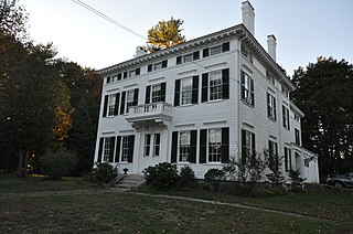
The Captain Reuben Merrill House is an historic house at 233 West Main Street in Yarmouth, Maine. Built in 1858, it is one of the town's largest and most elaborate 19th-century houses, and is one of three known surviving works of Portland architect Thomas J. Sparrow. It was placed on the National Register of Historic Places in 1974. It is now home to Maine Preservation, a statewide architectural preservation organization.

Yarmouth is a town in Cumberland County, Maine, United States, twelve miles north of the state's largest city, Portland. When originally settled in 1636, as North Yarmouth, it was part of the Massachusetts Bay Colony, and remained part of its subsequent incarnations for 213 years. In 1849, twenty-nine years after Maine's admittance to the Union as the twenty-third state, it was incorporated as the Town of Yarmouth.
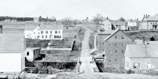
The historical buildings and structures of Yarmouth, Maine, represent a variety of building styles and usages, largely based on its past as home to almost sixty mills over a period of roughly 250 years. These mills include that of grain, lumber, pulp and cotton. Additionally, almost three hundred vessels were launched by Yarmouth's shipyards in the century between 1790 and 1890, and the homes of master shipwrights and ship captains can still be found throughout the town.

Sparhawk Mill is a former cotton mill on Bridge Street in Yarmouth, Maine, United States. Built in 1840 and made of brick, it is home today to The Garrison restaurant and several other businesses. It stands, just east of the town's Second Falls, on the site of several previous mill buildings, the earliest of which was a wooden mill dating to 1817.

Forest Paper Company was a pulp and paper mill on the Royal River in Yarmouth, Maine, United States, which was in business between 1874 and 1923. It was the first of its kind in New England. In 1909, it was the largest such mill in the world, employing 275 people. It produced 80 tons of poplar pulp each day.

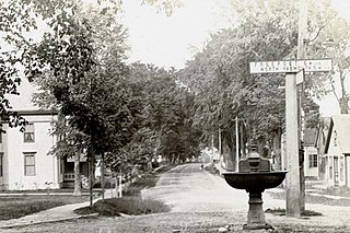
Main Street is a historic street in Yarmouth, Maine, United States. It is part of the 18-mile-long (29 km) State Route 115 (SR 115), the eastern terminus of which is in Yarmouth at the intersection of Marina Road and Lafayette Street (SR 88), at Yarmouth Harbor in the Lower Falls area. Its western end is a merging with Walnut Hill Road in North Yarmouth, at which point SR 115 continues west.
Henry Hutchins (1819–1889) was an American merchant shipwright during a prolific period at Yarmouth Harbor in Maine. His shipyard was one of the four major ones during the town's peak years, between 1850 and 1875.
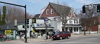
Andy's Handy Store, colloquially known as Handy Andy's, is a historic building in Yarmouth, Maine, United States. Located at 367 Main Street, at its junction with Elm Street in the town's Upper Village, part of the building dates to 1891. It has been the home to over thirty businesses. As of early 2022, Thoroughfare occupies the entire building.
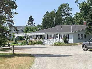
Homewood Inn is a former inn that was in business in Yarmouth, Maine, from 1912 to 1992. Although the buildings are still standing, they are now used as private residential units.
Nathaniel Foster was a noted 18th- and 19th-century American potter and merchant.

Brick Store is the colloquial name given to a historic three-unit building in Yarmouth, Maine, United States. Located at 357 Main Street, near its junction with Elm Street in the town's Upper Village, the building was completed in 1862. It has been the home to several business.

Yarmouth Marina is a natural harbor and estuary of Casco Bay, and is located adjacent to the town of Yarmouth, Maine, United States. It is situated on the Royal River, around 0.5 miles (0.80 km) southeast of the town center, in an area known as Lower Falls. Today it functions solely as a marina.
Bridge Street is a historic street in Yarmouth, Maine, United States. It runs for about 0.36 miles (0.58 km) from Willow Street in the north to the town's Main Street, State Route 115, in the south. The street's elevation is around 75 feet (23 m) at each end, while its middle section, at its crossing of the Royal River, is around 13 feet (4.0 m), a drop of around 62 feet (19 m).
Elm Street is a prominent street in Yarmouth, Maine, United States. It runs for about 2.7 miles (4.3 km) from North Road in the north to Portland Street in the south. The street's addresses are split between "West Elm Street" and "East Elm Street", the transition occurring at Main Street in the Upper Village. Several of its buildings are homes dating to the late 18th and early 19th centuries.

Portland Street is a historic street in Yarmouth, Maine, United States. It runs for about 1.25 miles (2.01 km) from the town's Main Street, State Route 115, in the north to its merge with Middle Road in the south. It is so named because it leads to Portland, the state's largest city, after linking up with State Route 9 in Falmouth, Maine.
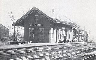
Yarmouth Junction station was a passenger rail station in Yarmouth, Maine, United States. It stood to the west of East Elm Street at Depot Road, at the junction of the former Grand Trunk Railway and the Maine Central Railroad, around 0.9 miles (1.4 km) north of the town's Railroad Square, where today's 1906-built Grand Trunk station stands. The Amtrak Downeaster utilizes the former Maine Central Railroad line, which passes to the northwest of town. The Yarmouth Junction station building is now gone, but the junction itself is still active.
Gilman Road is a prominent street in Yarmouth, Maine, United States. It runs for about 1.7 miles (2.7 km) from Lafayette Street in the northwest to the Ellis C. Snodgrass Memorial Bridge at White's Cove in the southeast. At the bridge, which connects the Yarmouth mainland to Cousins Island, the road becomes Cousins Road.
David Cleaves was an American potter in 19th-century Yarmouth, Maine. Cleaves Brook and Cleaves Street in that town are now named for him.

