Downlands Countryside Management Project

Last updated
The walks in the London Loop are within the project London Loop sign.JPG
The walks in the London Loop are within the project

The Downlands Countryside Management Project established in 1988 [1] is a partnership between six [2] London and Surrey local authorities set up to manage an area of countryside of 130 km² across the south of Outer London.

London Capital of the United Kingdom

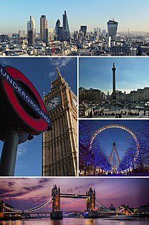
London is the capital and largest city of both England and the United Kingdom. Standing on the River Thames in the south-east of England, at the head of its 50-mile (80 km) estuary leading to the North Sea, London has been a major settlement for two millennia. Londinium was founded by the Romans. The City of London, London's ancient core − an area of just 1.12 square miles (2.9 km2) and colloquially known as the Square Mile − retains boundaries that follow closely its medieval limits. The City of Westminster is also an Inner London borough holding city status. Greater London is governed by the Mayor of London and the London Assembly.

Surrey County of England

Surrey is a subdivision of the English region of South East England in the United Kingdom. A historic and ceremonial county, Surrey is also one of the home counties. The county borders Kent to the east, East and West Sussex to the south, Hampshire to the west, Berkshire to the northwest, and Greater London to the northeast.

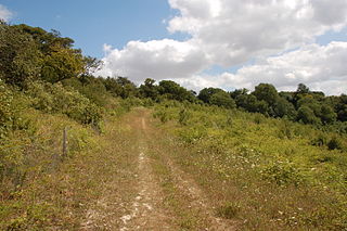
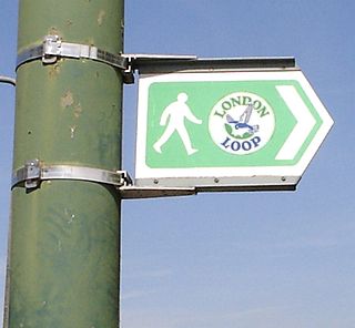
The main aims are the management of the rare chalk downland within the area; the development of an extensive network of trails (including the London Loop); and the improvements to signposting; rights of way; woodland and pond management.

Chalk A soft, white, porous sedimentary rock made of calcium carbonate

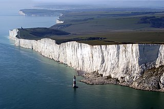
Chalk is a soft, white, porous, sedimentary carbonate rock, a form of limestone composed of the mineral calcite. Calcite is an ionic salt called calcium carbonate or CaCO3. It forms under reasonably deep marine conditions from the gradual accumulation of minute calcite shells (coccoliths) shed from micro-organisms called coccolithophores. Flint (a type of chert) is very common as bands parallel to the bedding or as nodules embedded in chalk. It is probably derived from sponge spicules or other siliceous organisms as water is expelled upwards during compaction. Flint is often deposited around larger fossils such as Echinoidea which may be silicified (i.e. replaced molecule by molecule by flint).

Downland An area of open chalk hills

A downland is an area of open chalk hills. This term is especially used to describe the chalk countryside in southern England. Areas of downland are often referred to as downs, deriving from a Celtic word for "hills".

Right-of-way (transportation) right to make a "way" (as in a type of easement) over a piece of land

A right-of-way (ROW) is a right to make a way over a piece of land, usually to and from another piece of land. A right of way is a type of easement granted or reserved over the land for transportation purposes, such as a highway, public footpath, rail transport, canal, as well as electrical transmission lines, oil and gas pipelines. A right-of-way can be used to build a bike trail. A right-of-way is reserved for the purposes of maintenance or expansion of existing services with the right-of-way. In the case of an easement, it may revert to its original owners if the facility is abandoned.

The Project is supported by the boroughs of Sutton and Croydon; and by Surrey County Council; the City of London Corporation; the Surrey districts of Reigate and Banstead and Tandridge; and the Countryside Agency. An additional partner is Natural Britain. [3]

London Borough of Sutton London borough in United Kingdom

The London Borough of Sutton is a London borough in South London, England and forms part of Outer London. It covers an area of 43 km2 (17 sq mi) and is the 80th largest local authority in England by population. It is one of the southernmost boroughs of London. It is south of the London Borough of Merton, west of the London Borough of Croydon and east of the Royal Borough of Kingston Upon Thames. The local authority is Sutton London Borough Council. Its principal town is the eponymous Sutton.

London Borough of Croydon London borough in United Kingdom

The London Borough of Croydon is a London borough in south London, England and is part of Outer London. It covers an area of 87 km2 (33.6 sq mi) and is the largest London borough by population. It is the southernmost borough of London. At its centre is the historic town of Croydon from which the borough takes its name. Croydon is mentioned in Domesday Book, and from a small market town has expanded into one of the most populous areas on the fringe of London. Croydon is the civic centre of the borough. The borough is now one of London's leading business, financial and cultural centres, and its influence in entertainment and the arts contribute to its status as a major metropolitan centre.

City of London Corporation municipal corporation of City of London

The City of London Corporation, officially and legally the Mayor and Commonalty and Citizens of the City of London, is the municipal governing body of the City of London, the historic centre of London and the location of much of the United Kingdom's financial sector.

Related Research Articles

North Downs Way

The North Downs Way National Trail is a long-distance path in southern England, opened in 1978. It runs from Farnham to Dover, past Guildford, Dorking, Merstham, Otford and Rochester, along the Surrey Hills Area of Outstanding Natural Beauty (AONB) and Kent Downs AONB.

A23 road major road in the United Kingdom

The A23 road is a major road in the United Kingdom between London and Brighton, East Sussex, England. It is managed by Transport for London for the section inside the Greater London boundary, Surrey County Council and West Sussex County Council for the section shadowed by the M23 motorway, the Highways Agency between the M23 and Patcham, and by Brighton and Hove Council from the A27 to the centre of Brighton.

Croydon town in South London, England

Croydon is a large town in south London, England, 9.5 miles (15.3 km) south of Charing Cross. The principal settlement in the London Borough of Croydon, it is one of the largest commercial districts outside Central London, with an extensive shopping district and night-time economy.

London Outer Orbital Path signed walk along public footpaths

The London Outer Orbital Path — more usually the "London LOOP" — is a 150-mile (242 km) signed walk along public footpaths, and through parks, woods and fields around the edge of Outer London, England, described as "the M25 for walkers". The walk begins at Erith on the south bank of the River Thames and passes clockwise through Crayford, Petts Wood, Coulsdon, Banstead, Ewell, Kingston upon Thames, Uxbridge, Elstree, Cockfosters, Chingford, Chigwell, Grange Hill and Upminster Bridge before ending at Purfleet, almost directly across the Thames from its starting point. Between these settlements the route passes through green buffers and some of the highest points in Greater London.

Sanderstead area of London

Sanderstead is a village and medieval-founded church parish in the London Borough of Croydon. It takes in Purley Downs and the Sanderstead Plantation, a large wooded park that includes the animated second-highest point in London. The area sits above a dry valley at the edge of the built-up area of Greater London. Cementing its secular identity from the late 19th century until abolition in 1965 it had a civil parish council. The community had a smaller farming-centred economy until the mid 19th century.

East Surrey (UK Parliament constituency) Parliamentary constituency in the United Kingdom

East Surrey is a constituency represented in the House of Commons of the UK Parliament since 2010 by Sam Gyimah of the Conservative Party. Its record is that of a Conservative safe seat based on time and opposition. It has elected a Conservative Party MP on an absolute majority since the seat's establishment, in 1918, and its greatest share of the vote for any opposition candidate was 33.75% in February 1974.

Croydon South (UK Parliament constituency) Parliamentary constituency in the United Kingdom (1974 onwards)

Croydon South is a United Kingdom parliamentary constituency created in 1974 represented in the House of Commons of the Parliament since 2015 by Chris Philp, a Conservative.

County Borough of Croydon

The County Borough of Croydon was a local government district in and around the town of Croydon in north east Surrey, England from 1889 to 1965. Since 1965 the district has been part of the London Borough of Croydon within Greater London.

Coulsdon and Purley Urban District former local government district in Surrey, UK

Coulsdon and Purley Urban District was a local government district in northeast Surrey from 1915 to 1965. The local authority was Coulsdon and Purley Urban District Council. The former area of the district is now mostly part of the London Borough of Croydon in Greater London, with parts in the Tandridge District and the Borough of Reigate and Banstead in Surrey.

Penge Urban District

Penge was a civil parish and a local government district located to the southeast of London, England. It included the settlements of Penge, Anerley and part of Crystal Palace. It was part of the London postal district, Metropolitan Police District and, from 1933, the London Passenger Transport Area. In 1965 the urban district was abolished by the London Government Act 1963 and it became part of Greater London, being combined with other districts to form the London Borough of Bromley.

Parks and open spaces in the London Borough of Croydon

The London Borough of Croydon has over 120 parks and open spaces within its boundaries, ranging from the 200 acre (80ha) Selsdon Wood Nature Reserve to many recreation grounds and sports fields scattered throughout the Borough. Croydon covers an area of 86.52 km², the 256th largest district in England. Croydon's physical features consist of many hills and rivers that are spread out across the borough and into the North Downs, Surrey and the rest of South London. Some of the open spaces in Croydon form part of the well-known London LOOP walks where the first section was opened on 3 May 1996 with a ceremony on Farthing Downs in Coulsdon. As a borough in Outer London it also contains some open countryside in the form of country parks. Croydon Council is associated with several other boroughs who are taking part in the Downlands Countryside Management Project. These boroughs are Sutton; and by Surrey County Council; the City of London Corporation; the Surrey districts of Reigate and Banstead and Tandridge; and the Countryside Agency. An additional partner is Natural Britain.

Croydon London Borough Council elections

Elections for the Council in the London Borough of Croydon are held every four years to elect 70 councillors. At the last elections, which were held in May 2014, 30 Conservative councillors and 40 Labour councillors, providing a Labour majority of ten seats.

Municipal Borough of Beddington and Wallington

Beddington and Wallington was, from 1915 to 1965, a local government district in north east Surrey, England. It formed part of the London suburbs, lying within the Metropolitan Police District and the London Passenger Transport Area. In 1965 it was abolished on the creation of Greater London.

Economy of the London Borough of Croydon

Croydon, located in Greater London, England, has a diverse economy with the service and retail sectors now dominating over the town's historical market status. It is today served well by its extensive rail network centering on East and West Croydon stations, from where London Overground, First Capital Connect and Southern operate to most parts of Greater London, Surrey, Sussex, Hampshire and the East of England. With the A23, M23 and M25 orbital motorway intersecting Croydon to the South East, it is the principal gateway of the motorway network from the East Sussex area of the South Coast. London Gatwick Airport is located to the direct south of the town and has scheduled flights to destinations within Europe, North America and Asia, although has tough competition from the even bigger London Heathrow Airport to the west but has managed to stay the UK's second busiest airport. The town has since 2000 had a tram network which has been highly successful, carrying more than 24 million passengers a year. The network has four lines with destinations including New Addington to Wimbledon, Beckenham to West Croydon, Elmers End to Therapia Lane, and Elmers End to West Croydon. Croydon is one of only five London boroughs not to have any form of London Underground services.

Devils Jumps, Treyford Group of barrows in England

The Devil's Jumps are a group of five large bell barrows situated on the South Downs 1.2 kilometres (0.75 mi) south-east of Treyford in the county of West Sussex in southern England. The Devil's Jumps site is listed as a Scheduled Ancient Monument and as a Local Nature Reserve. Most barrows along the South Downs have been damaged by agriculture and treasure hunters but the Devil's Jumps are considered to be the best preserved Bronze Age barrow group in Sussex. The barrows are laid out in a line running approximately south-east to north-west. The five barrows vary in diameter from 26 to 34 metres and stand up to 4.8 metres (16 ft) high. Two smaller barrows were situated close to the five main mounds. Traces remain of a sixth barrow. The Devil's Jumps have been dated to the Bronze Age and they are believed to be between three and four thousand years old. The Devil's Jumps were explored in the 19th century, when bones were found in two of the mounds, although some of the barrows contained no cremated remains at all. The main line of five barrows is aligned with sunset on Midsummer Day.

Coat of arms of the London Borough of Croydon

The coat of arms of the London Borough of Croydon is the official heraldic arms of the London Borough of Croydon, granted on 10 December 1965.

Eastbourne Downland Estate

The Eastbourne Downland, Eastbourne Downs or Eastbourne Downland Estate, is an area of land at the easternmost end of the South Downs National Park in East Sussex, England. It was bought by the public, following threats to the beauty spots of Beachy Head and the surrounding farmland, which led to a public campaign and Act of Parliament in 1926. It is currently owned and managed, on behalf of the public, by Eastbourne Borough Council.

References

  1. Surrey County Council
  2. Croydon LA [ permanent dead link ]
  3. "Downland project partners". Archived from the original on 2007-09-30. Retrieved 2007-07-27.