Dragon Swamp

Last updated

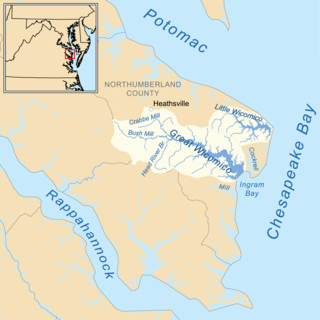
Dragon Swamp, [1] also known as Dragon Run , [2] is a 36.7-mile-long (59.1 km) [3] stream in the U.S. state of Virginia, flowing through King and Queen, Essex, Middlesex, and Gloucester counties. It is the main freshwater tributary of the Piankatank River.

The Dragon Run watershed in the U.S. state of Virginia encompasses 140 square miles (360 km2) and is home to many flora and fauna species. The brackish water stream, labeled on topographic maps as Dragon Swamp, is fed by underground springs, surface runoff, and numerous feeding swamps. In a study of 232 rivers and streams in the Chesapeake Bay, the Nature Conservancy and the Chesapeake Bay Foundation found the Dragon Run to rank second in terms of ecological significance. Efforts are being made to preserve the Dragon Run, including Governor Tim Kaine’s large purchase of land in order to maintain and protect the watershed’s original state.

U.S. state constituent political entity of the United States

In the United States, a state is a constituent political entity, of which there are currently 50. Bound together in a political union, each state holds governmental jurisdiction over a separate and defined geographic territory and shares its sovereignty with the federal government. Due to this shared sovereignty, Americans are citizens both of the federal republic and of the state in which they reside. State citizenship and residency are flexible, and no government approval is required to move between states, except for persons restricted by certain types of court orders. Four states use the term commonwealth rather than state in their full official names.

Virginia State of the United States of America

Virginia, officially the Commonwealth of Virginia, is a state in the Southeastern and Mid-Atlantic regions of the United States located between the Atlantic Coast and the Appalachian Mountains. Virginia is nicknamed the "Old Dominion" due to its status as the first English colonial possession established in mainland North America and "Mother of Presidents" because eight U.S. presidents were born there, more than any other state. The geography and climate of the Commonwealth are shaped by the Blue Ridge Mountains and the Chesapeake Bay, which provide habitat for much of its flora and fauna. The capital of the Commonwealth is Richmond; Virginia Beach is the most populous city, and Fairfax County is the most populous political subdivision. The Commonwealth's estimated population as of 2018 is over 8.5 million.

See also

Related Research Articles

Middlesex County, Virginia County in the United States

Middlesex County is a county located on the Middle Peninsula in the U.S. state of Virginia. As of the 2010 census, the population was 10,959. Its county seat is Saluda.

York River (Virginia) river in Virginia, United States

The York River is a navigable estuary, approximately 34 miles (55 km) long, in eastern Virginia in the United States. It ranges in width from 1 mile (1.6 km) at its head to 2.5 miles (4.0 km) near its mouth on the west side of Chesapeake Bay. Its watershed drains an area of the coastal plain of Virginia north and east of Richmond.

Little Schuylkill River river in the United States of America

The Little Schuylkill River is a 30.6-mile-long (49.2 km) tributary of the Schuylkill River in northeast Pennsylvania in the United States.

The Gasper River is a 38.6-mile-long (62.1 km) river in southwestern Kentucky, United States. It flows northeasterly into the Barren River. It is a rural river; the only town near it is Hadley in Warren County. It begins in northeast Logan County, and the river also flows through Warren and Logan counties. Tributaries include Belcher, Salt Lick, Brush, Clear Fork, Westbrook, and Rock House creeks.

Dragon Run State Forest is a Virginia state forest located in King and Queen County. 1,811 acres (7.33 km2) in size, it protects the Dragon Run Swamp while allowing for forest management. Hunting is permitted on the forest grounds.

The Piankatank River is a 24.4-mile-long (39.3 km) river in the U.S. state of Virginia. Located on the Middle Peninsula, between the Rappahannock and York rivers, it was the site of numerous actions during the American Civil War.

Buffalo Creek is a 21.1-mile-long (34.0 km) tributary of the Appomattox River in the U.S. state of Virginia. Flowing entirely through Prince Edward County, it joins the Appomattox River at Farmville.

Buffalo Creek is a 16.0-mile-long (25.7 km) tributary of the Maury River in Rockbridge County in the U.S. state of Virginia. It is part of the James River watershed.

Buffalo River (Virginia)

The Buffalo River is a 31.5-mile-long (50.7 km) tributary of the Tye River in the U.S. state of Virginia. It is part of the James River watershed.

The Eastern Branch Elizabeth River is a 9.0-mile-long (14.5 km) tidal river in the Hampton Roads area of the U.S. state of Virginia. The river flows from east to west, starting in Virginia Beach. At its crossing by Interstate 64 it becomes the boundary between Virginia Beach and the city of Norfolk, and farther west it is the boundary between Norfolk and the city of Chesapeake. For its final 3 miles (5 km) it is entirely within the city of Norfolk.

Flat Creek is a 34.0-mile-long (54.7 km) tributary of the Appomattox River in the U.S. state of Virginia. It rises just east of the town of Burkeville in Nottoway County and flows north into Amelia County, then northeast to join the Appomattox River 28 miles (45 km) northwest of Petersburg.

Knotts Creek is a 3.0-mile-long (4.8 km) tidal inlet on the south shore of the Nansemond River in the city of Suffolk, Virginia, in the United States.

The Little Calfpasture River is a 23.7-mile-long (38.1 km) tributary of the Maury River in the U.S. state of Virginia. It is part of the James River watershed.

The Little Piney River is a 7.6-mile-long (12.2 km) tributary of the Piney River in Amherst County in the U.S. state of Virginia. Via the Piney and Tye rivers, it is part of the James River watershed.

Little Wicomico River river in the United States of America

The Little Wicomico River is a 9-mile-long (14 km) river in the United States state of Virginia. The river, mostly tidal, flows into Chesapeake Bay at the junction of the south shore of the Potomac River, which is also the Maryland-Virginia boundary, with Chesapeake Bay.

Machipongo River river in Virginia, United States

The Machipongo River is a 16.5-mile-long (26.6 km) river in Accomack County on the Eastern Shore of the U.S. state of Virginia.

The North River is a 7.6-mile-long (12.2 km) tidal river in the U.S. state of Virginia. It is an arm of Mobjack Bay, itself part of Chesapeake Bay. The North River forms the boundary between Mathews and Gloucester counties.

The Severn River is a 2-mile-long (3 km) tidal river in the United States state of Virginia. It is a tributary of Mobjack Bay, which is an arm of Chesapeake Bay.

Cedar Run is a 37.5-mile-long (60.4 km) tributary of the Occoquan River in the U.S. state of Virginia.

References

  1. U.S. Geological Survey Geographic Names Information System: Dragon Swamp
  2. "Dragon Run / Piankatank River." Virginia Department of Game and Inland Fisheries. 2009. Web. 02 Nov. 2009. <http://www.dgif.virginia.gov/fishing/waterbodies/display.asp?id=168>.
  3. U.S. Geological Survey. National Hydrography Dataset high-resolution flowline data. The National Map Archived 2012-04-05 at WebCite , accessed April 1, 2011
International Standard Book Number Unique numeric book identifier

The International Standard Book Number (ISBN) is a numeric commercial book identifier which is intended to be unique. Publishers purchase ISBNs from an affiliate of the International ISBN Agency.

Coordinates: 37°34′04″N76°34′30″W / 37.56778°N 76.57500°W / 37.56778; -76.57500

Geographic coordinate system Coordinate system

A geographic coordinate system is a coordinate system that enables every location on Earth to be specified by a set of numbers, letters or symbols. The coordinates are often chosen such that one of the numbers represents a vertical position and two or three of the numbers represent a horizontal position; alternatively, a geographic position may be expressed in a combined three-dimensional Cartesian vector. A common choice of coordinates is latitude, longitude and elevation. To specify a location on a plane requires a map projection.