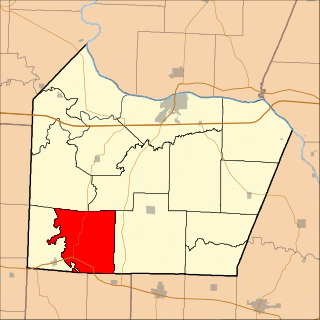
Dry Creek Township is an inactive township in Maries County, in the U.S. state of Missouri. [1]
A civil township is a widely used unit of local government in the United States that is subordinate to a county. The term town is used in New England, New York, and Wisconsin to refer to the equivalent of the civil township in these states. Specific responsibilities and the degree of autonomy vary based on each state. Civil townships are distinct from survey townships, but in states that have both, the boundaries often coincide and may completely geographically subdivide a county. The U.S. Census Bureau classifies civil townships as minor civil divisions. Currently, there are 20 states with civil townships.
Maries County is a county located in the U.S. state of Missouri. As of the 2010 census, the population was 9,176. Its county seat is Vienna. The county was organized March 2, 1855 and named for the Maries River and Little Maries River. 'Maries' is derived from the French marais, which means marsh, lake or pond.
In the United States, a state is a constituent political entity, of which there are currently 50. Bound together in a political union, each state holds governmental jurisdiction over a separate and defined geographic territory and shares its sovereignty with the federal government. Due to this shared sovereignty, Americans are citizens both of the federal republic and of the state in which they reside. State citizenship and residency are flexible, and no government approval is required to move between states, except for persons restricted by certain types of court orders.
Dry Creek Township took its name from a creek of the same name within its borders. [2]
Clear Creek Township is one of fourteen townships in Cooper County, Missouri, USA. As of the 2000 census, its population was 439.
Lamine Township is one of 14 townships in Cooper County, in the U.S. state of Missouri. As of the 2000 census, its population was 289.
Lebanon Township is one of fourteen townships in Cooper County, Missouri, USA. As of the 2000 census, its population was 333.
Dry Fork is a stream in Callaway County in the U.S. state of Missouri. It is a tributary of Cedar Creek.
Auglaize Township is an inactive township in Laclede County, in the U.S. state of Missouri.
Boone Township is an inactive township in Maries County, in the U.S. state of Missouri.
Miller Township is an inactive township in Maries County, in the U.S. state of Missouri.
Spring Creek Township is an inactive township in Maries County, in the U.S. state of Missouri.
Glaze Township is an inactive township in Miller County, in the U.S. state of Missouri.
Saline Township is an inactive township in Miller County, in the U.S. state of Missouri.
Burris Fork Township is an inactive township in Moniteau County, in the U.S. state of Missouri.
Buffalo Township is a township in Morgan County, in the U.S. state of Missouri.
Haw Creek Township is a township in Morgan County, in the U.S. state of Missouri.
Mill Creek Township is a township in Morgan County, in the U.S. state of Missouri.
Moreau Township is a township in Morgan County, in the U.S. state of Missouri.
Big Creek Township is an inactive township in Ozark County, in the U.S. state of Missouri.
Lick Creek Township is an inactive township in Ozark County, in the U.S. state of Missouri.
Spring Creek Township is an inactive township in Ozark County, in the U.S. state of Missouri.
Silver Creek Township is an inactive township in Randolph County, in the U.S. state of Missouri.
Boone Township is a township in Texas County, in the U.S. state of Missouri.
Coordinates: 38°03′25″N92°00′01″W / 38.0569°N 92.0003°W
A geographic coordinate system is a coordinate system that enables every location on Earth to be specified by a set of numbers, letters or symbols. The coordinates are often chosen such that one of the numbers represents a vertical position and two or three of the numbers represent a horizontal position; alternatively, a geographic position may be expressed in a combined three-dimensional Cartesian vector. A common choice of coordinates is latitude, longitude and elevation. To specify a location on a plane requires a map projection.
This Maries County, Missouri state location article is a stub. You can help Wikipedia by expanding it. |