
Quantico is a town in Prince William County, Virginia, United States. The population was 480 at the 2010 census. Quantico is approximately 35 miles southwest of Washington, D.C., bordered by the Potomac River to the east and the Quantico Creek to the north. The word Quantico is a corruption of the name of a Doeg village recorded by English colonists as Pamacocack.

Dumfries is a market town and former royal burgh in Dumfries and Galloway, Scotland, near the mouth of the River Nith on the Solway Firth, 25 miles (40 km) from the Anglo-Scottish border. Dumfries is the county town of the historic county of Dumfriesshire.

Dumfries, officially the Town of Dumfries, is a town in Prince William County, Virginia. The population was 4,961 at the 2010 United States Census.

Triangle is a census-designated place (CDP) in Prince William County, Virginia, United States. The population was 8,188 at the 2010 census. It is bounded to the south by the Marine Corps Base Quantico, which surrounds the town of Quantico.
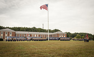
Marine Corps Base Quantico is a United States Marine Corps installation located near Triangle, Virginia, covering nearly 55,148 acres of southern Prince William County, Virginia, northern Stafford County, and southeastern Fauquier County. Used primarily for training purposes, MCB Quantico is known as the "Crossroads of the Marine Corps".

Quantico National Cemetery is a national cemetery in Triangle, Virginia for veterans who served in the United States Armed Forces. Adjacent to and originally part of Marine Corps Base Quantico, it was established as a national cemetery in 1983 with an area of 725 acres (293 ha).
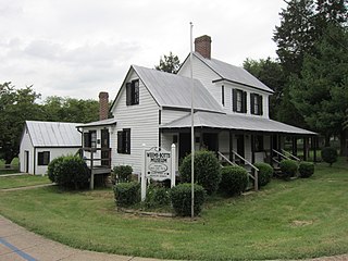
Weems–Botts House Museum is a small historic museum in Dumfries, Virginia, United States. The museum includes the landmark Weems–Botts House on the corner of Duke Street and Cameron Street and the Weems–Botts Museum Annex, which houses the Lee Lansing Research Library and Archive, located at 3944 Cameron Street. Both buildings are located in Merchant Park. The park's bandstand commemorates William Grayson, one of Prince William County's most respected citizens and one of Virginia's first senators. The museum tour showcases the history of Dumfries, Virginia's oldest chartered town, and people associated with the house, including Mason Locke "Parson" Weems, and attorney Benjamin Botts.

Prince William Forest Park is a National Park Service (NPS) site in the U.S. state of Virginia within Prince William County, located adjacent to the Marine Corps Base Quantico near the town of Dumfries. Established as Chopawamsic Recreational Demonstration Area in 1936, the park is the largest protected natural area in the Washington, D.C. metropolitan region at over 13,000 acres (5,300 ha).

Quantico Creek is a 13.7-mile-long (22.0 km) partially tidal tributary of the Potomac River in eastern Prince William County, Virginia. Quantico Creek rises southeast of Independent Hill, flows through Prince William Forest Park and Dumfries and empties into the Potomac at Possum Point.
Captain George Graham, a Virginia planter, lawyer, soldier and politician became an early federal government bureaucrat. He served twice as acting United States Secretary of War, including during the transition between the administrations of Presidents James Madison and James Monroe (1816-1817), as well as Commissioner of the United States General Land Office (1823-1830) under Presidents John Quincy Adams and Andrew Jackson.
Kopp is an extinct unincorporated community located in Prince William County, Virginia. The town began in 1885 and consisted, at one time, of a country store, school, post office, and Bellehaven Baptist Church, and was the home to about 100 local farming families. The town ceased to exist in 1942 when the federal government added about 50,000 acres to Marine Corps Base Quantico. The land upon which the residents of Kopp lived was purchased in what came to be known locally as "The Taking". It was located near the current town of Independent Hill on the western portion of the Marine Corps Base. No town buildings remain standing, and the church was demolished in about 1945, but the Marine Corps Base has been required to maintain the cemetery on the church grounds.
Joplin is an unincorporated community and former town in Prince William County, Virginia. The town was located on land taken to form Chopawamsic Recreational Demonstration Area and is now part of Prince William Forest Park, a National Park Service property located adjacent to Marine Corps Base Quantico. The remains of the town, now just a collection of homes, lies on a stretch of Va. 619, Joplin Road, about 3 miles west of Dumfries.

St. Bartholomew's Episcopal Church, also known as Green Hill Church, is a historic Episcopal church located near Quantico in Wicomico County, Maryland.

Dunscore is a small village which lies 9 miles (14 km) northwest of Dumfries on the B729, in Dumfriesshire, in the District Council Region of Dumfries and Galloway, southwest Scotland.

State Route 619 in Prince William County, Virginia is a secondary state highway. SR 619 provides a cross-county connector as well as a major artery for commuters. SR 619 is known by four names: Linton Hall Road, Bristow Road, Joplin Road, and Fuller Heights Road. There are also two short concurrencies: one with SR 234 Old in Independent Hill, and one with Fuller Military Road on the border of Marine Corps Base Quantico.

Cherry Hill is a census-designated place (CDP) in Prince William County, Virginia, United States. The population was 16,000 according to the 2010 Census. As of the 2020 census, it was estimated to be 23,683. The CDP is made up of the Cherry Hill peninsula, to the northeast of the town of Dumfries.

Hoddom is a small settlement and civil parish in Dumfries and Galloway, Scotland, dating back to the 8th century.
Kirkinner is a village in the Machars, in the historical county of Wigtownshire in Dumfries and Galloway, Scotland. About 3 miles (4.8 km) southwest of Wigtown, it is bounded on the east by the bay of Wigtown, along which it extends for about three miles, and on the north by the river Bladnoch.

Lavender Hill Cemetery is a cemetery in Cedar Road, Enfield, London, administered by the London Borough of Enfield. The cemetery opened in 1872 and has two facing chapels inside the entrance, one for Anglicans and another for non-conformists. The gates to the cemetery featured in all but the final episode of British sitcom On the Buses as the terminus of Stan and Jack's bus route: 'Cemetery Gates'.

Hollybrook Cemetery is a cemetery in Bassett, Southampton, England, containing around 53,000 graves as of August 2012 and still open to new burials as of March 2016. It is one of the main cemeteries in Southampton.


