
Haida Gwaii is an archipelago located between 55–125 km (34–78 mi) off the northern Pacific coast of Canada. The islands are separated from the mainland to the east by the shallow Hecate Strait. Queen Charlotte Sound lies to the south, with Vancouver Island beyond. To the north, the disputed Dixon Entrance separates Haida Gwaii from the Alexander Archipelago in the U.S. state of Alaska.

Gwaii Haanas National Park Reserve, National Marine Conservation Area, and Haida Heritage Site, usually referred to simply as Gwaii Haanas, is located in southernmost Haida Gwaii, 130 kilometres off the mainland of British Columbia, Canada. Gwaii Haanas protects an archipelago of 138 islands, the largest being Moresby Island and the southernmost being Kunghit Island. "Gwaii Haanas" means "Islands of Beauty" in X̱aayda kíl, the language of the Haida people.
Seton Portage Historic Provincial Park is a historic provincial park located in the community of Seton Portage, British Columbia, Canada. It was established on March 29, 1972 to commemorate the location of the first railway in the province of British Columbia.

Tantalus Provincial Park is a provincial park located in the Tantalus Range overlooking Squamish Valley in British Columbia, Canada. It was established on December 19, 1998 to protect a large area of pristine alpine wilderness.

BC Parks is an agency of the British Columbia Ministry of Environment and Climate Change Strategy that manages all of the, as of 2020, 1,035 provincial parks and other conservation and historical properties of various title designations within the province's Parks oversaw of the British Columbia Parks and Protected Areas System. The Lieutenant Governor-in-Council created the agency on March 1, 1911, through the Strathcona Park Act. The agency is charged with a dual role of preserving the ecological and historical integrity of the places entrusted to its management, while also making them available and accessible for public use and enjoyment.

Daajing Giids, known as Queen Charlotte City from 1891–2022, is a village municipality in the Haida Gwaii archipelago in the province of British Columbia, Canada. It is located on the southern end of Graham Island at Skidegate Inlet and is a member municipality of the North Coast Regional District.
Moresby Island is a large island that forms part of the Haida Gwaii archipelago in British Columbia, Canada, located at 52°45′00″N131°50′00″W. It is separated by the narrow Skidegate Channel from the other principal island of the group to the north, Graham Island.

Lyell Island, known also in the Haida language as Athlii Gwaii, is a large island in the Haida Gwaii archipelago on the North Coast of British Columbia, Canada. The island is a part of the Gwaii Haanas National Park Reserve and Haida Heritage Site.

Naikoon Provincial Park is a provincial park on northeastern Graham Island in the Haida Gwaii archipelago, British Columbia, Canada. It is the ancestral home of the Gwak'rala'chala people, one of the many tribes that form the native group Haida. While it is a popular destination for adventurous campers, it is also very secluded, being over 16 km (9.9 mi) away from Masset.

Anthony Island is an island located in the southern part of Haida Gwaii, off the North Coast of British Columbia, Canada, to the west of Kunghit Island, the archipelago's southernmost. Anthony Island is noted for being the location of the ruins of SkungWai or SG̱ang Gwaay Llnaagay, commonly called Ninstints after the reigning mid-19th Century chief there. SG̱ang Gwaay Llnagaay was a major village of the Kunghit Haida people.
SG̱ang Gwaay Llnagaay, commonly known by its English name Ninstints, is a village site of the Haida people and part of the Gwaii Haanas National Park Reserve and Haida Heritage Site on Haida Gwaii on the North Coast of British Columbia, Canada.
Hotspring Island, originally named in English as Volcanic Island and known in the Haida language as G̱andll K'in Gwaayaay ("Hot-Water-Island"), is a small island near the southeast coast of Lyell Island in the Haida Gwaii archipelago of the North Coast of British Columbia, Canada. The island's names derive from a hot spring located on its southwestern end, the temperature of which has been measured at 162 °F (72 °C). The island is part of Gwaii Haanas National Park Reserve and Haida Heritage Site and is supervised by the Haida Gwaii Watchmen.
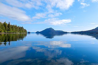
Gwaii Haanas National Marine Conservation Area Reserve and Haida Heritage Site is a National Marine Conservation Area of Canada. It is located off the coast of the southernmost Haida Gwaii, 130 kilometres off the mainland of British Columbia. It is immediately adjacent to Gwaii Haanas National Park Reserve and Haida Heritage Site. The level of protection differs from that of the National Park Reserve, however, allowing sustainable use of some natural resources in the area. Gwaii Haanas National Marine Conservation Area Reserve, which covers 3,400 square kilometres, is "a primary feeding habitat" of the humpback whale protected by Canada's Species at Risk Act (SARA).

Hlk'yah G̱awG̱a, also known as Windy Bay, is located on Athlii Gwaii in southern Haida Gwaii, British Columbia. The site was historically the location of a Haida village named Hlk'yah Llnagaay, meaning Peregrine Falcon Town in English. In the 1980s, Hlk'yah G̱awG̱a was the focus of a series of lawsuits and protests opposing clearcut logging on the island. These demonstrations were the impetus for the signing of the Gwaii Haanas Agreement of 1993 and the creation of the Gwaii Haanas National Park Reserve, National Marine Conservation Area Reserve, and Haida Heritage Site.

Tanu is a traditional Haida village site located on Tanu Island, Haida Gwaii, opposite of Kung'a Island in Laskeek Bay, within the Gwaii Haanas National Park Reserve and Haida Heritage Site.
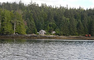
Rose Harbour is an unincorporated settlement on the north coast of Kunghit Island, on the south shore of the Houston Stewart Channel, in Haida Gwaii. It is within the bounds of Gwaii Haanas National Park Reserve and Haida Heritage Site. It is the only privately-owned property within Gwaii Haanas.

The Burdwood Group Conservancy is a conservancy located in the Broughton Archipelago in Mount Waddington Regional District, British Columbia. It was established by BC Parks on 13 March 2009 to protect a unique cluster of forested islands and islets situated at the entrance to Tribune Channel.
Neʼāhʼ Conservancy is a conservancy located in the Stikine Region of British Columbia, Canada. The conservancy was established on 31 March 2013 through a cooperative resource management and land use planning agreement between BC Parks and the Kaska Dena First Nations.
Gladys Lake Ecological Reserve is an ecological reserve located in the Eaglenest Range of the Spatsizi Plateau in north-central British Columbia, Canada. It was established in 1975 under the Ecological Reserves Act to facilitate scientific research of the region's alpine-subalpine ecosystems while discouraging outdoor recreation use. The reserve protects 44,098 hectares of pristine wilderness and is the largest ecological reserve in British Columbia.
