
El Dorado County, officially the County of El Dorado, is a county in the U.S. state of California. As of the 2020 census, the population was 191,185. The county seat is Placerville.
Sawtooth Range, Sawtooth Ridge, and Sawtooth Mountains may refer to:

The Desolation Wilderness is a 63,960-acre (258.8 km2) federally protected wilderness area in the Eldorado National Forest and Lake Tahoe Basin Management Unit, in El Dorado County, California. The crest of the Sierra Nevada runs through it, just west of Lake Tahoe.

The Granite Chief Wilderness is a 19,048 acre (77 km2) federally designated wilderness area of the Tahoe National Forest. Created by the California Wilderness Act of 1984, it is located in the Sierra Nevada mountains west of Lake Tahoe in the U.S. state of California. It is managed by the U.S. Forest Service Tahoe National Forest. Elevations range from 4,800 feet (1,500 m) to 9,019 feet (2,749 m) at the summit of Granite Chief.

The Lake Tahoe Basin Management Unit is a United States national forest that manages and protects public land surrounding Lake Tahoe and the Lake Tahoe Basin. Straddling the state borders of California and Nevada in the Sierra Nevada, the LTBMU encompasses 154,851 acres (626 km²) of National Forest system lands, ranging in altitude above sea level from 6,225 feet at lake level to 10,881 feet at Freel Peak. The U.S. Forest Service established the LTBMU in 1973. The name of the Lake Tahoe Basin Management Unit reflects a unique sort of National Forest, as unique as the resources of the Tahoe Basin.

Horsetail Falls is a waterfall in the Sierra Nevada mountain range, to the west of Lake Tahoe in the Desolation Wilderness of El Dorado County, California, United States. It falls in stages for nearly 500ft. It can be reached by hiking north out of the Twin Bridges trailhead on U.S. Route 50. There is a forest service parking area designated to the area.
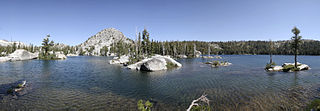
Lake Aloha is a large shallow backcountry reservoir located at an elevation of 8,116 feet in the Sierra Nevada Range, west of Lake Tahoe in El Dorado County, in eastern California.
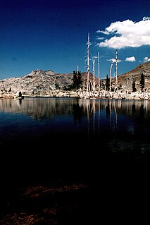
The Lake of the Woods is a backcountry glacial lake in the Desolation Wilderness of the Eldorado National Forest, southwest of Lake Tahoe, in El Dorado County, California. It lies just southeast of Lake Aloha.

The Glen Alpine Springs trailhead or Glen Alpine trailhead is located off Highway 89 a few miles north of South Lake Tahoe, California, at Fallen Leaf Lake just to the west of Lake Tahoe. The road to the trailhead is not plowed in winter.
The Twin Bridges trailhead or Pyramid Creek trailhead is located off U.S. Route 50 a couple miles east of Strawberry, California, west of Echo Pass.
The Lyons trailhead or Lyons Creek trailhead is located on Wrights Lake Road off Highway 50 about halfway to Wrights Lake.

Mount Tallac is a mountain peak southwest of Lake Tahoe, in El Dorado County, California. The peak lies within the Desolation Wilderness in the Eldorado National Forest. It is quite visible from State Routes 89 and 28, and U.S. Route 50. A "cross of snow" is clearly visible on the mountain's face during the winter, spring, and early summer months.

Eagle Lake is a backcountry lake in the Sierra Nevada mountain range, to the west of Lake Tahoe in the Desolation Wilderness. It can be reached by hiking west out of the Eagle Lake trailhead on HWY 89 at Emerald Bay State Park.
The South Warner Wilderness is a federally designated wilderness area 12 miles (19 km) east of Alturas, California, United States. It encompasses more than 70,000 acres (283 km2) of the Warner Mountains. It is within the Modoc National Forest and managed by the US Forest Service. Elevations range from 5,000 feet (1,500 m) to 9,895 feet at Eagle Peak.
Little Norway is a populated place in El Dorado County, California. It is located 14 kilometres (9 mi) west of Meyers, at an elevation of 2233m. The ZIP code is 95721.
The South Sierra Wilderness is a federally designated wilderness area in the Southern Sierra Nevada, in eastern California. It is located 65 miles (105 km) northeast of Bakersfield, and is southwest of Owens Lake and Olancha.
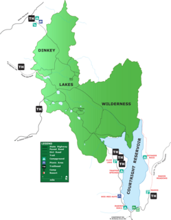
The Dinkey Lakes Wilderness is a federally designated wilderness area located 45 miles (72 km) northeast of Fresno, in the state of California, United States. It comprises 30,000 acres (12,141 ha) within the Sierra National Forest and was added to the National Wilderness Preservation System by the California Wilderness Act of 1984.
The Lower Sagehen Creek Hiking Trail follows Sagehen Creek, a tributary of the Truckee River on the east slope of the central Sierra Nevada in the western United States. The stream lies north of Lake Tahoe and the town of Truckee, California, and near the California/Nevada border.

The Tahoe–Yosemite Trail (TYT) is a long-distance trail in the Sierra Nevada mountain range of California. The trail courses 186 miles (299 km) from Meeks Bay at Lake Tahoe to Tuolumne Meadows in Yosemite National Park. The trail is a foot and equestrian path that passes through the Desolation, Mokelumne, Carson-Iceberg, Emigrant, and Yosemite Wilderness Areas and the Meiss Country (Dardanelles) Roadless Area.

Cascade Lake (California) is a glacier formed lake located in El Dorado County, California approximately 1 kilometre (0.62 mi) from Lake Tahoe. Cascade Lake is the second largest tributary lake feeding into Lake Tahoe. Its depth is 170 feet (52 m), 1 mile (1.6 km) long and 0.5 miles (0.80 km) wide. The lake is also within three to four miles from its neighboring lake, Fallen Leaf Lake (California), and Emerald Bay.

