Eagle River (Michigan)

Last updated
Eagle River

Eagle River Michigan.jpg

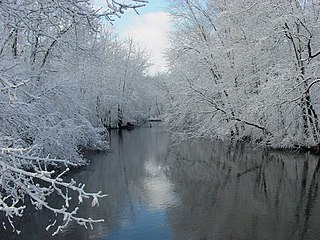
The Eagle River near its mouth in the community of Eagle River
Country United States
Physical characteristics
Main source at the confluence of its East and West Forks
47°23′21″N88°16′42″W / 47.38917°N 88.27833°W / 47.38917; -88.27833 [1]
River mouth in Eagle River, Michigan, at Lake Superior
47°24′54″N88°17′57″W / 47.41500°N 88.29917°W / 47.41500; -88.29917 Coordinates: 47°24′54″N88°17′57″W / 47.41500°N 88.29917°W / 47.41500; -88.29917 [1]
Eagle River Falls.jpg
Near minimum flow
Eagle River Falls High Flow.JPG
Near peak flow
Falls of the Eagle River in Eagle River

The Eagle River is a 2.6-mile-long (4.2 km) [2] stream on the Keweenaw Peninsula of the U.S. state of Michigan. The river flows into Lake Superior in the community of Eagle River. Most of the river lies within Houghton Township.

Stream A body of surface water flowing down a channel

A stream is a body of water with surface water flowing within the bed and banks of a channel. The stream encompasses surface and groundwater fluxes that respond to geological, geomorphological, hydrological and biotic controls.

Keweenaw Peninsula northernmost portion of Michigans Upper Peninsula

The Keweenaw Peninsula is the northernmost part of Michigan's Upper Peninsula. It projects into Lake Superior and was the site of the first copper boom in the United States. As of the 2000 census, its population was roughly 43,200. Its major industries are now logging and tourism, as well as jobs related to Michigan Technological University and Finlandia University.

U.S. state constituent political entity of the United States

In the United States, a state is a constituent political entity, of which there are currently 50. Bound together in a political union, each state holds governmental jurisdiction over a separate and defined geographic territory and shares its sovereignty with the federal government. Due to this shared sovereignty, Americans are citizens both of the federal republic and of the state in which they reside. State citizenship and residency are flexible, and no government approval is required to move between states, except for persons restricted by certain types of court orders. Four states use the term commonwealth rather than state in their full official names.

The main branch of the river is formed at the confluence of its East Branch [3] and its West Branch [4] at the community of Phoenix, about two miles southeast of its mouth, and parallels M-26 from Phoenix into Eagle River. [5]

Phoenix, Michigan Unincorporated community in Michigan, United States

Phoenix is an unincorporated community in Keweenaw County, Michigan, United States. Phoenix lies at the junction of M-26 and US 41, about two miles south of Eagle River, Michigan, near the shores of Lake Superior.

M-26 (Michigan highway) highway in Michigan, United States

M-26 is a 96.355-mile-long (155.068 km) state trunkline highway in the U.S. state of Michigan, running from two miles (3.2 km) east of Rockland to its junction with US Highway 41 (US 41) in Copper Harbor. It generally runs southwest-to-northeast in the western half or Michigan's Upper Peninsula. The northernmost segment, which closely parallels the shore of Lake Superior on the west side of the Keweenaw Peninsula, is highly scenic.

The east and west branches each run along the south side of the Cliff Range to meet in Phoenix and flow through a gap in the Cliff Range. The west branch rises about three miles southwest of Phoenix in northeastern Allouez Township. Cliff Drive runs alongside the river, and is joined by U.S. Highway 41 and M-26 about a mile and a quarter southeast of Phoenix. The only significant tributary on the west branch is Brodie Creek, which rises a bit further inland from the Cliff Range and enters the west branch just outside Phoenix.

Allouez Township, Michigan Civil township in Michigan, United States

Allouez Township is a civil township of Keweenaw County in the U.S. state of Michigan. As of the 2000 census, the township population was 1,584.

US Highway 41 (US 41) is a part of the United States Numbered Highway System that runs from Miami, Florida, to the Upper Peninsula of the US state of Michigan. In Michigan, it is a state trunkline highway that enters the state via the Interstate Bridge between Marinette, Wisconsin, and Menominee, Michigan. The 278.769 miles (448.635 km) of US 41 that lie within Michigan serve as a major conduit. Most of the highway is listed on the National Highway System. Various sections are rural two-lane highway, urbanized four-lane divided expressway and the Copper Country Trail National Scenic Byway. The northernmost community along the highway is Copper Harbor at the tip of the Keweenaw Peninsula. The trunkline ends at a cul-de-sac east of Fort Wilkins State Park after serving the Central Upper Peninsula and Copper Country regions of Michigan.

The east branch rises out of Beaver Pond about five miles east of Phoenix. It flows west along the south side of the Cliff Range, paralleled by US 41. The only significant tributary of the east branch is Buffalo Creek, which enters about three miles east of Phoenix.

See also

Related Research Articles

Au Sable River (Michigan) river in Michigan

The Au Sable River in Michigan, United States runs approximately 138 miles (222 km) through the northern Lower Peninsula, through the towns of Grayling and Mio, and enters Lake Huron at Au Sable. It is considered one of the best brown trout fisheries east of the Rockies and has been designated a blue ribbon trout stream by the Michigan Department of Natural Resources. In French, au sable literally means "at the sand." A 1795 map calls it the Beauais River.

Clarence Township, Michigan Township in Michigan, United States

Clarence Township is a civil township located in northeast Calhoun County in the U.S. state of Michigan. It is part of the Battle Creek, Michigan Metropolitan Statistical Area. The population was 1,985 at the 2010 census. The township was originally named Pinkney Township.

Paw Paw River river in Michigan

The Paw Paw River is located in the U.S. state of Michigan in the southwest portion of the lower peninsula. It is formed by the confluence of the north and south branches at 42°15′17″N85°55′36″W in Waverly Township in the northeast of Van Buren County. It flows approximately 61.8 miles (99.5 km) through Van Buren County and Berrien County until joining the St. Joseph River just above its mouth on Lake Michigan at Benton Harbor.

St. Joseph River (Maumee River tributary) tributary of the Maumee River in Ohio and Indiana

The St. Joseph River is an 86.1-mile-long (138.6 km) tributary of the Maumee River in northwestern Ohio and northeastern Indiana in the United States, with headwater tributaries rising in southern Michigan. It drains a primarily rural farming region in the watershed of Lake Erie.

Ottawa River (Lake Erie) river in Ohio and Michigan, United States

The Ottawa River, also known as Ottawa Creek, is a short river, approximately 20 miles (32 km) long, in northwest Ohio and southeast Michigan in the United States. It drains an area on the Ohio-Michigan border along the eastern and northern fringes of the city of Toledo, goes through Ottawa Hills, and empties directly into Lake Erie. It is one of two rivers in northwestern Ohio that share the same name, along with the Ottawa River that is a tributary of the Auglaize River. The upper 4 miles (6 km) of the river in Michigan north of Sylvania, Ohio is called North Tenmile Creek on federal maps, while another branch rising in Fulton County, Ohio, is called Tenmile Creek.

Bear River (Michigan) small clear slow moving river in the U.S. state of Michigan

Bear River is a small clear slow-moving river in the U.S. state of Michigan. 14.7 miles (23.7 km) long, it is the largest tributary of Little Traverse Bay in the northwest of the lower peninsula. Traverse Bay is on Lake Michigan. The river is formed as the outflow of Walloon Lake on the boundary between Charlevoix County and Emmet County, draining from the southeast end of the lake at 45°15′40″N84°56′01″W near the community of Walloon Lake in Melrose Township. M-75 has its northern terminus in a junction with US 131 nearby.

Pine River (Michigan) Wikimedia disambiguation page

Pine River may refer to any of the following streams in the U.S. state of Michigan:

  1. Pine River. The main branch forms with the confluence of the East and West Branches of the Pine River at 44°29′38″N83°23′16″W in Alcona County. The South Branch joins approximately 1.5 miles (2.4 km) to the south and flows into Iosco County, where it empties into Van Etten Lake at 44°29′38″N83°23′16″W northwest of Oscoda.
  2. Pine River. The main branch is formed by the confluence of the North and Middle Branches northeast of Standish and flows into the Saginaw Bay of Lake Huron at 43°58′32″N83°51′16″W. The South Branch Pine River joins the main stream at 43°59′08″N83°53′17″W.
  3. Pine River is a short waterway, which along with Round Lake, connects Lake Charlevoix with Lake Michigan at Charlevoix.
  4. Pine River rises in Chippewa County and flows south through Mackinac County into the St. Martin Bay of Lake Huron at 46°03′09″N84°39′22″W The North Pine River, also known as the North Branch Pine River, joins at 46°12′20″N84°36′17″W. Another tributary, Hemlock Creek, is also known as Pine River.
  5. Pine River, also known as the South Branch Manistee River, rises in southeast Wexford County, flows southwest across northwest Osceola County, then west and north through the northeast corner of Lake County and back into southwest Wexford County, emptying into the Tippy Dam Pond on the Manistee River at 44°13′37″N85°54′27″W. The main stream is formed from the confluence of the East Branch Pine River with the North Branch Pine River at 44°06′02″N85°31′40″W. Another tributary, the Spaulding Creek, is also known as the Little Pine River
  6. Pine River, in Marquette County, is a very short stream draining Pine Lake into Lake Superior at 46°53′27″N87°52′13″W, north of the Huron Mountains.
  7. Pine River rises in from Pine Lake in eastern Mecosta County, flows mostly south and east through Isabella County, then south along eastern edge of Montcalm County, then east and north through Gratiot County and Midland County, emptying into the Chippewa River at 43°36′06″N84°17′33″W, just about two miles before it joins the Tittabawassee River near Midland. The South Branch Pine River joins the main stream at 43°30′37″N85°00′02″W Another tributary, Miller Creek, is also sometimes known as Pine River or the West Branch Pine River. The North Branch Pine River joins the main stream at 43°26′03″N84°50′18″W.
  8. Pine River empties into the St. Clair River at 42°49′13″N82°29′08″W on the south side of St. Clair. The South Branch Pine River joins the main stream at 42°58′11″N82°37′10″W. Another tributary, Quakenbush Drain, is also sometimes known as Pine River.
  9. Pine Creek empties into Lake Superior and is also known as the Pine River.
Cass River (Michigan) river in the United States of America

The Cass River is a 61.5-mile-long (99.0 km) river in the Thumb region of the U.S. state of Michigan. It drains large portions of Sanilac and Tuscola counties and smaller portions of Genesee, Huron, Lapeer, and Saginaw counties.

Black River is an 11.0-mile-long (17.7 km) river on the Upper Peninsula of the U.S. state of Michigan. The river flows into Lake Michigan at 46°05′37″N85°20′30″W, approximately 5 miles (8 km) east of Naubinway.

Dowagiac River river in the United States of America

The Dowagiac River is a southwesterly flowing 30.9-mile-long (49.7 km) stream in the Lower Peninsula of the U.S. state of Michigan. It is tributary to the St. Joseph River which flows, in turn, into eastern Lake Michigan.

Cedar River (Gladwin County, Michigan) river in Clare and Gladwin counties, Michigan, United States

The Cedar River is a 29.0-mile-long (46.7 km) river in the U.S. state of Michigan, flowing through Clare County and Gladwin County.

Cedar River is an 11.6-mile-long (18.7 km) stream in Antrim County in the U.S. state of Michigan and is part of the Elk River Chain of Lakes Watershed, a tributary of Lake Michigan.

Coldwater River is a 29.5-mile-long (47.5 km) stream in the U.S. state of Michigan. Located in Branch County, the river rises in Ovid Township at 41°50′14″N84°59′13″W as the outflow of Coldwater Lake. Flowing north and west, it is joined by the outflow from the Lake of the Woods and continues north for several miles. West of the city of Coldwater, it flows through a series of lakes: South Lake, Messenger Lake, Cemetery Lake, North Lake, Randall Lake, Morrison Lake, Craig Lake, and Hodunk Pond. It then continues to the northwest and empties into the St. Joseph River in the village of Union City at 42°03′58″N85°07′48″W.

Coldwater River (Western Michigan)

The Coldwater River is a 19.4-mile-long (31.2 km) stream in the U.S. state of Michigan. Located in western Michigan, the river is a part of the Grand River drainage basin.

Galien River river in the United States of America

The Galien River is a 30.0-mile-long (48.3 km) stream in the southwest region of the U.S. state of Michigan. The river begins at the outlet of Dayton Lake and flows in a predominantly westerly direction until it enters southeastern Lake Michigan at New Buffalo. The South Branch Galien River rises just north of the border with Indiana, at the confluence of Spring Creek and the Galena River, the latter rising in LaPorte County, Indiana.

Cedar Creek may refer to several small streams in the U.S. state of Michigan:

The Mitchigan River is a 14.9-mile-long (24.0 km) stream in the Upper Peninsula of the U.S. state of Michigan. It flows into the Fence River at 46°17′27″N88°09′58″W in northeast Iron County in Mansfield Township. The Fence River is a tributary of the Michigamme River, which is itself a tributary the Menominee River, flowing to Lake Michigan. The Mitchigan River has its source in the southeast corner of Baraga County at 46°24′58″N88°08′05″W. It flows mostly southward along the boundary between Iron and Marquette counties, crossing briefly into western Marquette County.

Saganing River river in the United States of America

The Saganing River, also known as Saganing Creek, is a 10.0-mile-long (16.1 km) stream in the U.S. state of Michigan.

Sturgeon River (Cheboygan County, Michigan) river in the U.S. state of Michigan, flowing mostly northward through Otsego and Cheboygan counties

Sturgeon River is a 40.8-mile-long (65.7 km) river in the U.S. state of Michigan, flowing mostly northward through Otsego and Cheboygan counties.

The Baldwin River is a 25.2-mile-long (40.6 km) stream in the U.S. state of Michigan.

References