
Sgurr na Lapaich is a mountain in the Northwest Highlands of Scotland, situated north of Loch Mullardoch in the high ground that separates Glen Cannich and Glen Strathfarrar. The mountain reaches a height of 1,150 metres, and is the fourth highest mountain north of the Great Glen. There is no higher ground to the north of it in Great Britain.
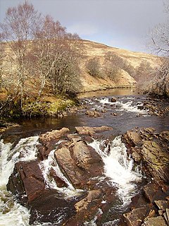
The River Cassley in Sutherland, in northern Scotland, joins the River Oykel to form the Kyle of Sutherland at Invercassley. The Kyle is subsequently joined by the River Shin and River Carron before it becomes the Dornoch Firth and enters the North Sea. The main road bridge over the river is at Rosehall, halfway between the mouth and the impressive Achness Waterfall or Cassley Falls.
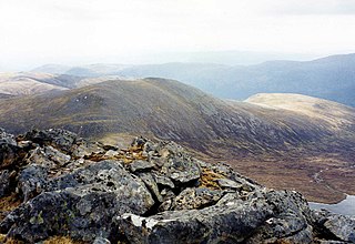
Càrn nan Gobhar is a Scottish mountain situated on the northern side of Loch Mullardoch in the upper part of Glen Cannich. It stands some 50 kilometres west-southwest of the city of Inverness in a remote group of four Munros informally known as “The Mullardochs” which form the high ground between Loch Mullardoch and Loch Monar.

Glen Cannich is a long glen in the Northwest Highlands of Scotland and through which runs the River Cannich. Emerging from the reservoir of Loch Mullardoch, the river flows east to merge with the River Affric at the village of Cannich, their combined waters forming the River Glass.
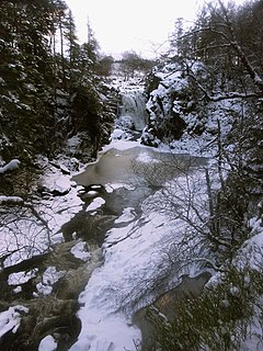
Achness Falls, also known as the Achness Waterfall or Cassley Falls, is a waterfall located on the River Cassley in Sutherland, Scotland, near Rosehall and Invercassley. Its name is derived from the Scottish Gaelic Ach-an-eas, the "field of the waterfall".

Bearreraig Waterfall is a waterfall of Scotland.

Corrimony Falls is a waterfall on the River Enrick, near Corrimony in Glenurquhart, in the Highland council area of Scotland. It is a local tourist attraction in the spring and summer.

Dog Falls is a series of waterfalls on the River Affric, in Glen Affric in the Highlands of Scotland. The falls are within the Glen Affric National Nature Reserve, managed by Forestry Commission Scotland. There are several way-marked paths to the falls.
Eas an Dubhaidh is a waterfall of Scotland.
Eas an Fhithich is a waterfall of Scotland. It is located one mile west of the village of Cannich, at the southern end of Strathglass, in the Highlands of Scotland, about 26 miles (42 km) west of the city of Inverness.

Plodda Falls is a waterfall, situated 5 km south-west of the village of Tomich, near Glen Affric, in the Highlands of Scotland. The falls are 46 m high, and are on the Allt na Bodachan, near where it flows into the Abhainn Deabhag, which in turn joins with the River Affric to form the River Glass.

Rogie Falls are a series of waterfalls on the Black Water, a river in Ross-shire in the Highlands of Scotland. The falls are about 2 km north-west of the village of Contin, next to the A835 road. They are a popular tourist attraction, with several forest walks.

Eas Mòr is a waterfall on the Duirinish peninsula of the island of Skye in Scotland. It lies on the Allt Mhicheil, a tributary of the Dibidal River below Healabhal Bheag. The area is uninhabited and there is a second fall where the Dibidal River flows into the sea at Geodha Mòr north of MacLeod's Maidens.
Eas Mor, River Torridon is a waterfall of Scotland.
Falls of Divach is a waterfall of Scotland. Pronounced 'Jeevach', the Divach Burn falls 100 feet to the River Coiltie, which continues its course through Lewiston village, the "Cover", then into Urquhart Bay, half way along the northern shore of Loch Ness.

Falls of Orrin is a waterfall on the River Orrin, in the Highlands of Scotland.
Falls of Pattack is a waterfall in the Scottish Highlands' Cairngorm National Park. The falls are on the River Pattack, about 2 km south of the A86 road between Kinloch Laggan and Feagour.
The River Glass is a river in the Scottish Highlands which flows northeastwards down Strathglass. It begins at the confluence of the River Affric and the Abhainn Deabhag, near the village of Tomich. It is joined by the River Cannich near the village of Cannich, then flows as far as a confluence with the River Farrar near Struy, from which point the merged waters are known as the River Beauly.

Loch Mullardoch is a major reservoir in Glen Cannich in the Northwest Highlands of Scotland. It was created by the damming in 1951 of the River Cannich just upstream of Mullardoch House, as part of the Affric-Beauly hydro-electric power scheme. A car park at the southern end of the dam is the terminus of the public road up Glen Cannich. The reservoir extends for about 14 km westwards up the glen to the point where the Abhainn a Choilich and Abhainn Sithidh burns drop down from the West Benula deer forest.

Inverness Museum and Art Gallery is a museum and gallery on Castle Wynd in Inverness in the Highlands of Scotland. Admission is free. The collection and facilities are managed by High Life Highland on behalf of Highland Council.

