East Sanday Coast

Last updated
East Sanday Coast
Location Orkney, Scotland
Coordinates 59°16′00″N2°31′00″W / 59.266667°N 2.516667°W / 59.266667; -2.516667 Coordinates: 59°16′00″N2°31′00″W / 59.266667°N 2.516667°W / 59.266667; -2.516667
Area15.15 km2 (5.85 sq mi) [1]
Established1997
Governing body Joint Nature Conservation Committee

The East Sanday Coast is a protected wetland area on and around the island of Sanday, the third-largest of the Orkney islands off the north coast of Scotland. With a total protected area of 1,515 hectares, the 55 kilometre stretch of coast includes rocky and sandy sections, sand dunes, machair habitats, intertidal flats, and saltmarsh. It has been protected as a Ramsar Site since 1997. [1]

Sanday, Orkney island in the north of the Orkney Islands, Scotland

Sanday is one of the inhabited islands of Orkney that lies off the north coast of mainland Scotland. With an area of 50.43 square kilometres (19.5 sq mi), it is the third largest of the Orkney Islands. The main centres of population are Lady Village and Kettletoft. Sanday can be reached by Orkney Ferries or by plane from Kirkwall on the Orkney Mainland.

Orkney archipelago in northern Scotland

Orkney, also known as the Orkney Islands, is an archipelago in the Northern Isles of Scotland, situated off the north coast of the isle of Great Britain. Orkney is 16 kilometres (10 mi) north of the coast of Caithness and comprises approximately 70 islands, of which 20 are inhabited. The largest island, Mainland, is often referred to as "the Mainland", and has an area of 523 square kilometres (202 sq mi), making it the sixth-largest Scottish island and the tenth-largest island in the British Isles. The largest settlement and administrative centre is Kirkwall.

Scotland country in Northwest Europe, part of the United Kingdom

Scotland is a country that is part of the United Kingdom. It covers the northern third of the island of Great Britain, with a border with England to the southeast, and is surrounded by the Atlantic Ocean to the north and west, the North Sea to the northeast, the Irish Sea to the south, and more than 790 islands, including the Northern Isles and the Hebrides.

The area supports a large number of over-wintering waders and waterbirds, including internationally important populations of purple sandpiper and ruddy turnstone. It is also important for breeding populations of great black-backed gulls and common seals. [2]

Purple sandpiper species of bird

The purple sandpiper is a small shorebird. The genus name is from Ancient Greek kalidris or skalidris, a term used by Aristotle for some grey-coloured waterside birds. The specific maritima is from Latin and means "of the sea", from mare, "sea".

Ruddy turnstone species of bird

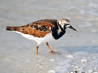
The ruddy turnstone is a small wading bird, one of two species of turnstone in the genus Arenaria. The scientific name is from Latin. The genus name arenaria derives from arenarius, "inhabiting sand, from arena, "sand". The specific interpres means "messenger"; when visiting Gotland in 1741, Linnaeus thought that the Swedish word Tolk "interpreter" applied to this species, but in the local dialect the word means "legs" and is used for the redshank.

Great black-backed gull species of bird

The great black-backed gull, mistakenly called greater black-backed gull by some, is the largest member of the gull family. It breeds on the European and North American coasts and islands of the North Atlantic and is fairly sedentary, though some move farther south or inland to large lakes or reservoirs. The adult great black-backed gull has a white head, neck and underparts, dark grey wings and back, pink legs and yellow bill.

As well as the East Sanday Coast being recognised as a wetland of international importance under the Ramsar Convention, [1] the whole of the island of Sanday has been designated a Special Area of Conservation. [3]

Ramsar Convention international treaty for the conservation and sustainable utilization of wetlands

The Ramsar Convention on Wetlands of International Importance especially as Waterfowl Habitat is an international treaty for the conservation and sustainable use of wetlands. It is also known as the Convention on Wetlands. It is named after the city of Ramsar in Iran, where the Convention was signed in 1971.

A Special Area of Conservation (SAC) is defined in the European Union's Habitats Directive (92/43/EEC), also known as the Directive on the Conservation of Natural Habitats and of Wild Fauna and Flora. They are to protect the 220 habitats and approximately 1000 species listed in annex I and II of the directive which are considered to be of European interest following criteria given in the directive. They must be chosen from the Sites of Community Importance by the State Members and designated SAC by an act assuring the conservation measures of the natural habitat.

Related Research Articles

A Ramsar site is a wetland site designated to be of international importance under the Ramsar Convention.

Roebuck Bay Western Australia

Roebuck Bay is a bay on the coast of the Kimberley region of Western Australia. Its entrance is bounded in the north by the town of Broome, and in the south by Bush Point and Sandy Point. It is named after HMS Roebuck, the ship captained by William Dampier when he explored the coast of north-western Australia in 1699. The Broome Bird Observatory lies on the northern coast of the bay.

Elizabeth and Middleton Reefs Marine National Park Reserve geographical object

Elizabeth and Middleton Reefs Marine National Park Reserve is a former Marine protected area consisting of waters around Elizabeth and Middleton Reefs located at the south-eastern end of the Coral Sea Islands, an Australian territory in the Coral Sea and the north-western Tasman Sea. It was incorporated into the new Lord Howe Commonwealth Marine Reserve in December 2012. The two reefs also form a Ramsar site, having been listed as Ramsar Site 1223, on 21 October 2002, under the Ramsar Convention as a wetland of international importance.

Great Sandy Strait

The Great Sandy Strait is a strait in the Australian state of Queensland of 70 kilometres (43 mi) length which separates mainland Queensland from the World Heritage listed Fraser Island.

Deben Estuary

Deben Estuary is a 981.1 hectare biological Site of Special Scientific Interest (SSSI) covering the River Deben and its banks 12 kilometres from its mouth north of Felixstowe to Woodbridge in Suffolk. It is a Ramsar internationally important wetland site and a Special Protection Area under the European Union Directive on the Conservation of Wild Birds. It is also in the Suffolk Coast and Heaths Area of Outstanding Natural Beauty. It partly overlaps two geological SSSIs, Ferry Cliff, Sutton and Ramsholt Cliff.

Colne Estuary biological and geological Site of Special Scientific Interest near Brightlingsea in Essex

Colne Estuary is a 2915 hectare biological and geological Site of Special Scientific Interest near Brightlingsea in Essex. It is also a Nature Conservation Review site, a National Nature Reserve, a Ramsar wetland site of international importance, a Special Protection Area, a Special Area of Conservation, and a Geological Conservation Review site. Three areas in the site are managed by the Essex Wildlife Trust, Colne Point, Fingringhoe Wick and Howlands Marsh.

Poda Protected Area lake in Bulgaria

The nature conservation site Poda was declared a protected area in 1989 by the Bulgarian Ministry of Water and Environment. It was the first protected area in Bulgaria that is completely managed and maintained by a non-governmental organization, the Bulgarian Society for the Protection of Birds(BSPB). BSPB prepares and implements activities adopted by the Council of Minister's Management Plan, but receives its funding completely from entrance fees, souvenirs sold, and donations. Through this arrangement, it aims to be a sustainable model for nature conservation, environmental education, and eco-tourism.

Central Asian Flyway organization

The Central Asian Flyway (CAF), Central Asian-Indian Flyway, or Central Asian-South Asian Flyway is a flyway covering a large continental area of Eurasia between the Arctic Ocean and the Indian Ocean and the associated island chains. The CAF comprises several important migration routes of waterbirds, most of which extend from the northernmost breeding grounds in Siberia to the southernmost non-breeding wintering grounds in West Asia, India, the Maldives and the British Indian Ocean Territory.

Coral Sea Reserves Ramsar Site

The Coral Sea Reserves Ramsar Site comprises the 17,292 km2 of oceanic island and reef habitats within the former Coringa-Herald National Nature Reserve and the former Lihou Reef National Nature Reserve in the Australian Coral Sea Islands Territory.

Hunter Estuary Wetlands

The Hunter Estuary Wetlands comprise a group of associated wetlands at and near the mouth of the Hunter River in the city of Newcastle, New South Wales, Australia. Some 30 km2 of the wetlands has been recognised as being of international importance by designation under the Ramsar Convention. It was listed on 21 February 1984 as Ramsar site 287. A larger area of the wetlands has been identified by BirdLife International as an Important Bird Area (IBA). The wetlands are recognised as the most important area in New South Wales for waders, or shorebirds.

Simpsons Saltings Suffolk Wildlife Trust nature reserve

Simpson's Saltings is a 25 hectare nature reserve on the Suffolk coast east of Hollesley. It is managed by the Suffolk Wildlife Trust. It is in the Suffolk Coast and Heaths Area of Outstanding Natural Beauty, and part of the Alde-Ore Estuary Site of Special Scientific Interest, Ramsar internationally important wetland site, Special Area of Conservation, Special Protection Area under the European Union Directive on the Conservation of Wild Birds, and Grade I Nature Conservation Review site,

Jiwani Coastal Wetland A wetland located in Balochistan, Pakistan, near the town of Jiwani

The Jiwani Coastal Wetland is a wetland located in Balochistan, Pakistan, near the town of Jiwani. The site is one of the 19 Ramsar sites in Pakistan and was inducted in 2001.

Berthas Beach Important Bird Area

Bertha's Beach Important Bird Area comprises 3300 ha of coastal wetlands at the entrance to Choiseul Sound, on the east coast of East Falkland, in the Falkland Islands. It lies about 8 km south-east of Mount Pleasant Airport and 40 km south-west of Stanley. It has been identified by BirdLife International as an Important Bird Area (IBA) because of its significancer for a variety of migratory waders and other waterbirds. Overlapping it is the 4000 ha Bertha's Beach Ramsar site, recognising it as a wetland of international importance.

Logan Lagoon is a 2172 ha wetland Conservation Area on Flinders Island, the largest of the Furneaux Group at the eastern end of Bass Strait, which is part of the Australian state of Tasmania.

Orwell Estuary

Orwell Estuary is a 1,335.7 hectare biological Site of Special Scientific Interest which stretches along the River Orwell and its banks between Felixstowe and Ipswich in Suffolk. It is part of the Stour and Orwell Estuaries Ramsar site internationally important wetland site and Special Protection Area under the European Union Directive on the Conservation of Wild Birds. It is also in the Suffolk Coast and Heaths Area of Outstanding Natural Beauty.

Bridgend Flats is an area of mudflats and saltmarsh near the village of Bridgend on the island of Islay off the west coast of Scotland. Covering an area of 331 hectares, it is situated around the outflow of the River Sorn into Loch Indaal.

Caithness and Sutherland Peatlands Peatland in nothern Scotland

The Caithness and Sutherland Peatlands is a large area of blanket bog and peatland, covering a number of disconnected regions across the historic counties of Caithness and Sutherland in the far north of Scotland, across an area known as the Flow Country. With a total area of 143,503 hectares, it is one of the largest recognised conservation sites in the UK, and is the largest Ramsar Site in Scotland.

Caithness Lochs Series of lochs in northern Scotland

Caithness Lochs is a protected wetland area in the historic county of Caithness in the far north of Scotland. With a total area of 1,379 hectares, it covers six freshwater lochs and a complex area of fen and swamp, and has been protected as a Ramsar Site since 1998.

The Kintyre Goose Roosts are a group of five oligotrophic hill lochs on the Kintyre peninsula in Argyll and Bute, western Scotland. With a total area of 312 hectares, they have been protected as a Ramsar Site since 1998.

References

  1. 1 2 3 "East Sanday Coast". Ramsar Sites Information Service. Retrieved 18 February 2019.
  2. "East Sanday Coast 13013 RIS 2005" (PDF). Ramsar Sites Information Service. Retrieved 18 February 2019.
  3. "Sanday - Special Area of Conservation - SAC - Habitats Directive". Joint Nature Conservation Committee . Retrieved 18 February 2019.