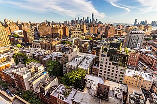
Greenwich Village, or simply The Village, is a neighborhood on the west side of Lower Manhattan in New York City, bounded by 14th Street to the north, Broadway to the east, Houston Street to the south, and the Hudson River to the west. Greenwich Village also contains several subsections, including the West Village west of Seventh Avenue and the Meatpacking District in the northwest corner of Greenwich Village.

Alphabet City is a neighborhood located within the East Village in the New York City borough of Manhattan. Its name comes from Avenues A, B, C, and D, the only avenues in Manhattan to have single-letter names. It is bounded by Houston Street to the south and 14th Street to the north, and extends roughly from Avenue A to the East River. Some famous landmarks include Tompkins Square Park, the Nuyorican Poets Cafe and the Charlie Parker Residence.

The East Village is a neighborhood on the East Side of Lower Manhattan in New York City, United States. It is roughly defined as the area east of the Bowery and Third Avenue, between 14th Street on the north and Houston Street on the south. The East Village contains three subsections: Alphabet City, in reference to the single-letter-named avenues that are located to the east of First Avenue; Little Ukraine, near Second Avenue and 6th and 7th Streets; and the Bowery, located around the street of the same name.

Fifth Avenue is a major and prominent thoroughfare in the borough of Manhattan in New York City, New York, United States. It stretches north from Washington Square Park in Greenwich Village to West 143rd Street in Harlem. It is one of the most expensive shopping streets in the world.

The Pyramid Club was a nightclub in the East Village of Manhattan, New York City. After opening in 1979, the Pyramid helped define the East Village drag, gay, punk and art scenes of the 1980s. The club was located at 101 Avenue A in Manhattan.
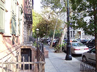
The West Village is a neighborhood in the western section of the larger Greenwich Village neighborhood of Lower Manhattan, New York City. The West Village is bounded by the Hudson River to the west and 14th Street to the north. The eastern boundary is variously cited as Greenwich Avenue, Seventh Avenue, or Sixth Avenue, while the southern boundary is either Houston Street or Christopher Street.

George Frederick Pelham was an American architect and the son of George Brown Pelham, who was also an architect.

Lafayette Street is a major north–south street in New York City's Lower Manhattan. It originates at the intersection of Reade Street and Centre Street, one block north of Chambers Street. The one-way street then successively runs through Chinatown, Little Italy, NoLIta, and NoHo and finally, between East 9th and East 10th Streets, merges with Fourth Avenue. A buffered bike lane runs outside the left traffic lane. North of Spring Street, Lafayette Street is northbound (uptown)-only; south of Spring Street, Lafayette is southbound (downtown)-only.


The Angel Orensanz Center is an art and performance space at 172 Norfolk Street, between Stanton Street and East Houston Street, on the Lower East Side of Manhattan in New York City. It was originally built as a synagogue, running through a succession of congregations and continues to be used as one occasionally. It was erected in 1849, making it the oldest surviving synagogue building in New York City, and the fourth-oldest surviving synagogue building in the United States. It was the largest synagogue in the United States at the time of its construction and is one of the few built in Gothic Revival style.


Village Preservation is a non-profit organization which advocates for the preservation of architecture and culture in several neighborhoods of Lower Manhattan, New York. Since it began in 1980, it has engaged in efforts to attain landmark status for a variety of sites like the Stonewall Inn and Webster Hall. The organization and its Executive Director, Andrew Berman, have been described as influential in New York real estate, while some of its activities to prevent development and to support restrictive zoning have attracted criticism.

The South Village is a largely residential area that is part of the larger Greenwich Village in Lower Manhattan, New York City, directly below Washington Square Park. Known for its immigrant heritage and bohemian history, the architecture of the South Village is primarily tenement-style apartment buildings, indicative of the area's history as an enclave for Italian-American immigrants and working-class residents of New York.

German Evangelical Lutheran Church of St. Mark is a historic church and synagogue building at 323 East 6th Street between First and Second Avenues in the East Village neighborhood of Manhattan, New York City. The Renaissance Revival style church was built in 1847 by the Evangelical Lutheran Church of St. Matthew which first rented it to St. Mark's and subsequently sold it to them in 1857. By the end of the nineteenth century the congregation was in decline as congregants were moving elsewhere. Much of the church membership was killed in the 1904 General Slocum disaster, most of the victims being women and children, and the congregation never recovered.

The Yiddish Theatre District, also called the Jewish Rialto and the Yiddish Realto, was the center of New York City's Yiddish theatre scene in the early 20th century. It was located primarily on Second Avenue, though it extended to Avenue B, between Houston Street and East 14th Street in the East Village in Manhattan. The District hosted performances in Yiddish of Jewish, Shakespearean, classic, and original plays, comedies, operettas, and dramas, as well as vaudeville, burlesque, and musical shows.

Alexander Saeltzer was a German-American architect active in New York City in the 1850s and 1860s. His work includes the Anshe Chesed Synagogue, Academy of Music, Theatre Francais, the Duncan, Sherman & Company building and the South Wing of the Romanesque revival structure at 425 Lafayette Street built between 1853 and 1881 as the Astor Library.
Charles Street is a street in the West Village neighborhood of Manhattan in New York City. It runs east to west from Greenwich Avenue to West Street. The street was named after Charles Christopher Amos, who owned the parcel the street passed through. Amos is also the namesake of Christopher Street, two blocks to the south, and the former Amos Street, which is now West 10th Street. Charles Lane is a one-block alley located between Charles and Perry Streets and Washington and West Streets. From 1866 to 1936, the section of Charles Street between Bleecker Street and West 4th Street was called Van Ness Place after a farm, owned by the Van Ness family, which had occupied the square bounded by Bleecker, West 4th, Charles and Perry Streets until 1865.