Easton on the Hill Rural District

Last updated

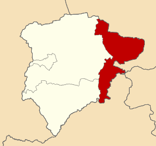
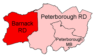
Easton on the Hill was a rural district in Northamptonshire, England from 1894 to 1935. It was formed under the Local Government Act 1894 from that part of the Stamford rural sanitary district which was in Northamptonshire proper (other successor districts were Uffington Rural District in Lincolnshire, Ketton Rural District in Rutland, and Barnack Rural District in the Soke of Peterborough). It consisted of the three parishes of Collyweston, Duddington and Easton on the Hill.

Rural districts were a type of local government area – now superseded – established at the end of the 19th century in England, Wales, and Ireland for the administration of predominantly rural areas at a level lower than that of the administrative counties.

Northamptonshire County of England

Northamptonshire, archaically known as the County of Northampton, is a county in the East Midlands of England. In 2015 it had a population of 723,000. The county is administered by Northamptonshire County Council and by seven non-metropolitan district councils. It is known as "The Rose of the Shires".

England Country in north-west Europe, part of the United Kingdom

England is a country that is part of the United Kingdom. It shares land borders with Wales to the west and Scotland to the north. The Irish Sea lies west of England and the Celtic Sea to the southwest. England is separated from continental Europe by the North Sea to the east and the English Channel to the south. The country covers five-eighths of the island of Great Britain, which lies in the North Atlantic, and includes over 100 smaller islands, such as the Isles of Scilly and the Isle of Wight.

The district was abolished in 1935 under a County Review Order, becoming part of the new Oundle and Thrapston Rural District.

Local Government Act 1929 United Kingdom legislation

The Local Government Act 1929 was an Act of the Parliament of the United Kingdom that made changes to the Poor Law and local government in England and Wales.

Oundle and Thrapston was a rural district in Northamptonshire, England from 1935 to 1974.

Related Research Articles

Borough of Wellingborough Borough in England

The Borough of Wellingborough is a Non-metropolitan district and borough in Northamptonshire, England. It is named after Wellingborough, its main town, but also includes surrounding rural areas.

Ketton Rural District

Ketton was a rural district in Rutland, England from 1894 to 1974, covering the east of the county. The district was named after Ketton.

Melton was a rural district in Leicestershire, England from 1894 to 1935.

Thrapston was a rural district in England from 1894 to 1935. It was one of the only rural districts to be split between administrative counties, with part in Northamptonshire and part in Huntingdonshire.

Gretton was a rural district in Northamptonshire, England from 1894 to 1935. It was formed from the Northamptonshire part of the Uppingham rural sanitary district.

Oundle was a rural district in England from 1894 to 1935.

Kettering was a rural district in Northamptonshire in England from 1894 to 1974.

Oxendon was a rural district in Northamptonshire, England from 1894 to 1935.

The Brixworth Rural District was a rural district in Northamptonshire, England from 1894 to 1974,. It was named after and administered from the village of Brixworth.

Barnack Rural District

Barnack was a rural district in the Soke of Peterborough and later Huntingdon and Peterborough from 1894 to 1974.

Uffington was a rural district in Lincolnshire, Parts of Kesteven from 1894 to 1931.

Northampton was a rural district in Northamptonshire, England from 1894 to 1974.

Bingham Rural District

Bingham was a rural district in Nottinghamshire, England from 1894 to 1974.

Leake was a rural district in Nottinghamshire, England from 1894 to 1935.

Stapleford Rural District

Stapleford was a rural district in Nottinghamshire, England from 1894 to 1935.

The Daventry Rural District was a rural district in Northamptonshire, England from 1894 to 1974. It entirely surrounded the municipal borough of Daventry. The district was administered from Daventry but did not include the town.

Middleton Cheney Rural District

Middleton Cheney was a rural district in Northamptonshire, England from 1894 to 1935.

Eaton Bray was a rural district in Bedfordshire, England from 1894 to 1933. It was created by the Local Government Act 1894 based on that part of the Leighton Buzzard rural sanitary district which was in Bedfordshire. The headquarters of the district were in the village of Eaton Bray.

Grantham was a rural district in Lincolnshire, Parts of Kesteven from 1894 to 1931.

References

Coordinates: 52°37′N0°31′W / 52.61°N 0.51°W / 52.61; -0.51

Geographic coordinate system Coordinate system

A geographic coordinate system is a coordinate system that enables every location on Earth to be specified by a set of numbers, letters or symbols. The coordinates are often chosen such that one of the numbers represents a vertical position and two or three of the numbers represent a horizontal position; alternatively, a geographic position may be expressed in a combined three-dimensional Cartesian vector. A common choice of coordinates is latitude, longitude and elevation. To specify a location on a plane requires a map projection.